A view of the theater at Termessos.
A visit to the ancient city of Termessos is a great half-day trip from Antalya, Turkey. We visited Termessos in the morning and then took a refreshing dip in the Mediterranean Sea at the Konyaalti Beach Park near Antalya in the afternoon. The ruins are about 35 km inland and sits in a narrow and high mountain valley—the road up to the site is good, although winding and somewhat steep. Anciently, this region was known as Pisidia, and due to the fierceness of the people and its strategic defensive location, Alexander could not conquer Termessos (in 333 BC). The Romans who came later chose an alliance with Termessos rather than risk war in 70 BC.

Part of the gymnasium ruins at Termessos.
The ruins include a large theater in a dramatic setting, an agora, temples, tombs, a gymnasium, necropolis and remnants of houses.

The Tomb of Alcetas – note the carved figure on the horse above my shoulder.

A dramatic backdrop for the Termessos theater, which held 4,000 people.
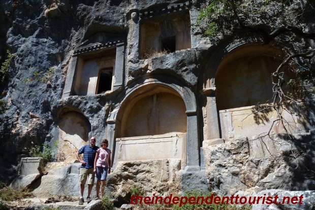
Some of the rock-carved tombs at Termessos.
Practical Information
There are some interpretive signs at the site and also a small map available at the entrance. The ruins are inside the large Termessos National Park, which is known for its abundance of wildlife. At the entrance to the park is a restaurant and small botanical museum. From the entrance, a 9 km paved road takes you up to the parking area at the base of the ruins. You will see ruins of some buildings and the massive walls on the road up to the site, giving a feel as to how large this city was.
There are toilets at the ruins but no water or snacks, so bring these items with you. It is a bit of a hike from the parking lot up to the main site, which is large, and mostly hidden from view from the base. The trails are fairly steep, so be prepared with good hiking shoes. I suggest a loop route, going from the parking lot up to the left of the Artemis-Hadrian Temple (as recognized by the large doorway arch) and returning on the trail to the right (or behind the Artemis-Hadrian Temple). This return trail passes a number of interesting tombs in the rock hillside (see picture above).

The Temple of Artemis-Hadrian near the parking area. The trail behind this temple goes up to some tombs.
Due to the climb from sea level, Termessos is definitely cooler than Antalya and was very comfortable in September. The entry fee was 5 TL per person (1.8 Turkish Lira (TL) to 1 USD in 2012).
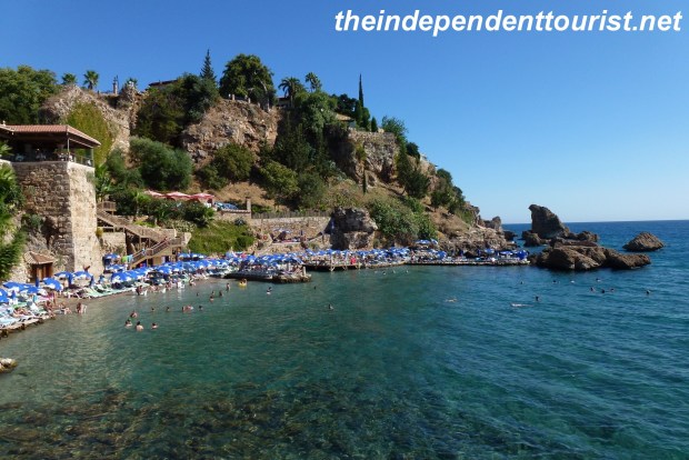
Konyaalti Beach Park. On your way back to Antalya, stop at this great beach. There was a 4 TL parking fee, but the beach is free. The water and beach were very clean.

Konyaalti Beach – a great way to spend the afternoon after hiking around Termessos.


")


 Church_Goreme Turkey (3)")
 Church_Goreme Turkey (2)")
 Church_Goreme Turkey (1)")

")


")
")
")
")
")
")
")
")
")
")
")
")
")
")
")
")

")
")
")
")
")
")
")


")
")
")
")
")
")
")
")
")
")
")
")
")
")
")
")
")
")
")
")
")
")
")
")
")
")
")
")
")
")


")
")


")
")
")

")

")

")
