Egypt

Alexandria – One of the Great Cities of Ancient Times

Out of all the places I’ve visited in Egypt, Alexandria probably had the least to offer the tourist, and yet there was no way I was going to pass up an opportunity to go there, given its illustrious history. I’ve read that “Alexandria is the greatest historical city with the least to show” and that seems to be true, unfortunately. For a map of places visited in Egypt, click here, scroll to bottom of page.

A typical street scene in Alexandria. Very non-touristy!

A typical street scene in Alexandria. Very non-touristy!

Buying some fruit from a local Egyptian vendor.

Buying some fruit from a local Egyptian vendor.

Alexandria was the home of Queen Cleopatra and the city rivaled Rome in beauty. It was the center of scientific learning with a world-renown library (700,000 volumes). It also had a huge lighthouse (called Pharos) that was a wonder of the ancient world (394 feet high) and was in working order for 1,700 years (until an earthquake toppled it in 1303).

Alexandria was founded by Alexander the Great (in 331 BC) and was one of the greatest cities of antiquity. Alexander is buried here, but the exact location of his tomb is not known. The city of Cleopatra’s time is now largely under water and about 18 ft. below street level. Every so often there are major finds, such as the Roman catacombs discovered in 1900 when a donkey disappeared through the ground.

Here are a few things to see in Alexandria:

Roman Amphitheater (Kom Al-Dikka). This is the only Roman Amphitheater in Egypt. It is well preserved and if you stand in the right spot on the center stage, the acoustics allow you to hear your voice being amplified around the theater. There are more excavations going on in this area.

The Roman Amphitheater in Alexandria.

The Roman Amphitheater in Alexandria.

Pompey’s Pillar and Serapeum. This area contains several above-ground ruins and underground chambers. The Pillar was erected in AD 291 to support a statue of the Emperor Diocletian and is still standing in its original spot. The pillar takes its name from the Roman general Pompey who was murdered by Cleopatra’s brother (although he has nothing to do with the pillar). The Serapeum was a large temple complex which also had a huge library. The underground chambers show the foundation and library remains.

Pompey's Pillar and the surrounding ruins of the Serapeum.

Pompey’s Pillar and the surrounding ruins of the Serapeum.

Roman Catacombs (Kom Ash-Shuqqafa). Close to Pompey’s Pillar are the Roman catacombs, which is probably the most fascinating historical site in Alexandria. Unfortunately, I could not take pictures in the catacombs (except for one quick shot below). There are three underground levels, the lowest of which is flooded, but the other two levels are open and can be visited with a guide—even the 2nd level has some water on the floor, which you avoid by walking on planks. You descend via a staircase and enter a large rotunda with numerous rooms branching off in every direction. The catacombs were constructed in the 2nd century AD and eventually housed the remains of 300 people. Before visiting, be sure to check opening hours and days of the week.

An ancient sarcophagus at the entrance to the Roman catacombs.

An ancient sarcophagus at the entrance to the Roman catacombs.

One sneaky photo in the Roman catacombs.

One sneaky photo in the Roman catacombs.

The Al-Corniche. Alexandria is a long narrow city built along the Mediterranean shoreline. The Corniche is a popular socializing spot for locals, especially after dark, with street vendors selling all kinds of snacks and young couples strolling hand in hand enjoying the fresh breeze.

The Corniche in Alexandria.

The Corniche in Alexandria.

From the Corniche you can glimpse Fort Qaitbey, which was built in 1480 on the remains of the ancient Pharos lighthouse. The fort is open to the public but our short visit (just one full day) did not afford us time to go out and see it.

Reference Source: Lonely Planet Egypt

Fort Qaitbey is in the far distance at the right edge of the picture.

Fort Qaitbey is in the far distance at the right edge of the picture.

Climbing Mt. Sinai – An Unforgettable Experience

One of our most memorable experiences in Egypt was visiting St. Katherine’s Monastery and climbing to the summit of Mt. Sinai. It’s about a two and a half-hour drive through the unforgiving interior desert landscape from the resort of Na’ama Bay to St. Katherine’s Monastery, where the hike begins to Mt. Sinai.

A view of the Sinai peninsula landscape on the way to Mt. Sinai.

A view of the Sinai peninsula landscape on the way to Mt. Sinai.

St. Katherine’s Monastery

This area has been a pilgrimage site for centuries and is holy ground to three religions: Christians, Muslims, and Jews. According to the Old Testament, this is the place of numerous revelations by God (including the Ten Commandments) to the prophet Moses. The Israelites camped in this area for some time after miraculously escaping from the Egyptian armies by crossing the Red Sea on dry land.

The Bell Tower at St. Katherine's Monastery. It houses 9 bells donated by Tsar Alexander II from Russia.

The Bell Tower at St. Katherine’s Monastery. It houses 9 bells donated by Tsar Alexander II from Russia.

Considered one of the oldest continually functioning monastic communities in the world, much of the compact monastery is off limits to tourists, but it is still worth a visit and is the spot where all tourists begin their hike up Mt. Sinai.

A view of the Monastery walls and some local camels.

A view of the Monastery walls and some local camels.

The 20 or so monks living here are Greek Orthodox and the first church was built here in about 337 AD, commemorating the spot where God spoke to Moses in the form of a burning bush. Interestingly, a descendant of an evergreen bush which grows nowhere else in the Sinai is found here.

This evergreen is believed to be a descendant of the burning bush. Transplanted here in the 10th century from the nearby chapel of the same name.

This evergreen is believed to be a descendant of the burning bush. Transplanted here in the 10th century from the nearby chapel of the same name.

The Byzantine Emperor Justinian fortified the location and built the main Basilica of the Transfiguration in 527 AD on the grounds of the original church which became the origin of the monastery.

Mt. Sinai

There are two ways to climb the Mount (altitude: 2,285 meters or 7,500 ft). There is the “camel path” which is wider and more “gently” sloping, or taking what is called the “Steps of Repentance” route– a very steep climb of 3,750 steps (hard on the knees) which was built by a monk doing penance—what a price to pay! We took the camel path, and it joins the “Steps of Repentance” path 750 steps below the summit.

On the trail with Mount Sinai behind me - about halfway up.

On the trail with Mount Sinai behind me – about halfway up.

Going through a narrow gorge. Getting ready for the final ascent.

Going through a narrow gorge. Getting ready for the final ascent.

Hiking up the last 750 steps to the summit. In the distance below is Elijah's basin. The cypress tree is thought to be 1,000 years old. Those who traveled with Moses up the mountain waited here while he ascended to the summit to speak with God.

Hiking up the last 750 steps to the summit. In the distance below is Elijah’s basin. The cypress tree is thought to be 1,000 years old. Those who traveled with Moses up the mountain waited here while he ascended to the summit to speak with God.

You can take a camel up the path but we decided to hike it, and even at a good pace it took us about 2 hours to reach the summit from the Monastery. This is not an easy hike, and several members of our group ended up not making it to the top.

The Chapel of the Holy Trinity at the summit of Mt. Sinai.

The Chapel of the Holy Trinity at the summit of Mt. Sinai.

A magnificent view from the top of Mt. Sinai.

A magnificent view from the top of Mt. Sinai.

A lot of tourists leave at around 3 am to reach the summit for the sunrise. We were not that ambitious and arrived at the summit around noon. My wife and I had the top of this sacred mountain to ourselves at that time of day. The views are incredible and although the landscape is harsh (reminding me a bit of Death Valley), it was thrilling to be on the Mount which holds so much historical and religious significance to many people.

References: Lonely Planet Egypt, DK Eyewitness Travel Egypt.

The Sinai Peninsula – A Totally Different Egypt and Gateway to the Red Sea

After two weeks touring the dusty ancient ruins of Egypt, we felt like we had traveled to a different planet when we arrived at the Sharm el-Sheikh Airport from Luxor. While both airports are modern, the minute you step outside in Sharm el-Sheikh you notice the difference – the more humid air, and the end of bargains. The taxi drivers wanted E£ 200 (at the time about $40 USD) for a 2-3 mile ride to our hotel that would have cost E£ 15-20 in other parts of the country, and they would rather walk away than bargain.

My sister on Na'ama Bay beach.

My sister on Na’ama Bay beach.

Lots of water toys available for rent in Na'ama Bay.

Lots of water toys available for rent in Na’ama Bay.

We stayed at the Hilton Hotel in Na’ama Bay (a bit more resort-like and next door to the larger town of Sharm el Sheikh) which felt more like Cancun than Egypt – a promenade with lots of restaurants, posh hotels and tourists—especially from Russia.

The promenade at Na'ama Bay - lined with restuarants and shops.

The promenade at Na’ama Bay – lined with restuarants and shops.

Even though it’s more of a cushy resort area, nice hotels can be had for about $50 US per night.

One of the nine pools at the Hilton Sharm Dreams Resort. Great hotel.

One of the nine pools at the Hilton Sharm Dreams Resort. Great hotel.

This is a divers’ paradise. The Red Sea has some of the best diving in the world. Lots of tour companies will take you out for day trips to the reefs and shipwrecks. Unfortunately we’re not divers, but we did enjoy snorkeling. My sister and her husband took a glass-bottom boat tour.

One of the glass bottom boat tours available in Na'ama Bay.

One of the glass bottom boat tours available in Na’ama Bay.

The water is incredibly clear and full of life, with unique coral formations and marine species not found elsewhere on the planet. We took a taxi out to Ras Mohammed National Park and did some snorkeling from the beach. Lots of dive boats were just off shore; this is one of the best spots in the Red Sea.

The imposing entrance to Ras Mohammed National Park.

The imposing entrance to Ras Mohammed National Park.

An incredible beach at Ras Mohammed National Park.

An incredible beach at Ras Mohammed National Park.

One of the coral walls that goes straight down into the depths at Ras Mohammed National Park.

One of the coral walls that goes straight down into the depths at Ras Mohammed National Park.

Sharm el-Sheikh was claimed by Israel after the 1967 war (it was returned to Egypt in 1982 and that is when development took off), and it experienced some terrorist activity about 10 years ago. However, it is probably one of the safest tourist spots in Egypt now. There are security barriers and guards at the entrance to the town. Your car may be checked, but this is for your protection as a tourist.

A view of the shore heading back to Na'ama Bay from Ras Mohammed National Park.

A view of the shore heading back to Na’ama Bay from Ras Mohammed National Park.

It would be a huge mistake to visit Egypt and not go to the Sinai. We also climbed Mt. Sinai (think Moses and the 10 Commandments) and I will discuss that day trip in a separate post.

Three Must-Do Sights on the West Bank of the Nile (Ancient Thebes)

As mentioned in my other post on Thebes (located on West Bank of the Nile), there is lots to see in this area just across the river from Luxor, Egypt. The three sights below are “must do’s”, two of which are major tourist sights (the third receives far fewer tourists). For a map of places visited in Egypt click here.

Valley of the Kings

The Valley of the Kings is the number one tourist spot in ancient Thebes. It’s the location of the tomb of the world famous King Tut and many other pharaohs from the 18th – 20th Dynasties (1550-1069 BC).

At the entrance to the Valley of the Kings.

At the entrance to the Valley of the Kings.

Some of the tombs were known and open as far back as Greek and Roman times and others were discovered more recently (such as King Tut’s, which was just discovered in 1922). Many of the artifacts from King Tut’s tomb are found in the Egyptian Museum in Cairo (a new Grand Egyptian Museum is set to open in March 2015 near the Giza Pyramids). Your ticket will allow you to see three tombs in one day and the number of visitors to each tomb is limited (King Tut’s requires a separate ticket).

In one of the plain chambers of the tombs I quickly took this picture.

In one of the plain chambers of the tombs I quickly took this picture.

It is just about impossible to get meaningful pictures in the Valley of the Kings since photos aren’t allowed in the tombs and the exteriors are just dark entrance ways with signage. However, the tombs themselves are incredible. Many of the tombs are accessed via long corridors going deep into the hillsides, some have chambers in addition to the main tombs. These tombs are carved out of solid rock and the walls and ceilings of most corridors and rooms are highly decorated with beautiful paintings.

Climbing up to the Tomb of Tuthmosis III - the tomb was dug 100 feet above the valley floor in an attempt to keep thieves out (didn't work!).

Climbing up to the Tomb of Tuthmosis III – the tomb was dug 100 feet above the valley floor in an attempt to keep thieves out (didn’t work!).

The sign at the entrance of the tomb of Tuthmosis III (1479 - 1425 BC). The "KV 34" means it was the 34th tomb discovered in the "Kings Valley."

The sign at the entrance of the tomb of Tuthmosis III (1479 – 1425 BC). The “KV 34” means it was the 34th tomb discovered in the “Kings Valley.”

Sixty-two tombs have been excavated to-date, and there are probably more to be discovered. This remote location was chosen to thwart grave robbers, but even though many tombs were hard to reach, robbers found a way into almost all of the tombs.

Temple of Hatshepsut (Deir al-Bahri)

The Temple of Hatshepsut at the base of a dramtic limestone cliff.

The Temple of Hatshepsut at the base of a dramtic limestone cliff.

This temple was constructed by Queen Hatshepsut in the 18th Dynasty (she reigned from 1473-1458 BC). The setting is dramatic and the temple is in good condition and from a distance is almost looks new—hard to believe it’s 3,500 years old.

The decorated rooms of the Temple of Hatshepsut.

The decorated rooms of the Temple of Hatshepsut.

A carved pillar in the courtyard of the Temple of Tuthmosis III next to the Temple of Hatshepsut.

A carved pillar in the courtyard of the Temple of Tuthmosis III next to the Temple of Hatshepsut.

There are many carved and painted reliefs still in good condition even after thousands of years. There are also some older temple ruins on the site. Be prepared for the crowds here.

Medinat Habu Temple

This temple is huge, and 2nd to only Karnak in size (Karnak is located on the East Bank north of Luxor). However, it receives fewer visitors since it is a little off the beaten track from the Valley of the Kings and the Temple of Hatshepsut.

My mother-in-law, wife and sister in front of the Medinat Habu Temple.

My mother-in-law, wife and sister in front of the Medinat Habu Temple.

The carved pillars in the Second Court of Medinat Habu Temple.

The carved pillars in the Second Court of Medinat Habu Temple.

It is the mortuary temple of Ramses III (reigned 1184 – 1153 BC) and was patterned after the mortuary temple of Ramses II (the Ramesseum, nearby). Medinat Habu has survived in much better condition than the Ramesseum.

Another view of the Second Court of Medinat Habu Temple.

Another view of the Second Court of Medinat Habu Temple.

The temple area was inhabited until the 9th century and was the center of economic life in Thebes for centuries. Allow a couple hours to wander the extensive ruins.

Less Visited Sights of the West Bank (Ancient Thebes) near Luxor, Egypt

The West Bank of the Nile (across from Luxor) has a number of interesting sights, some of which very few tourists visit. Lots of boats will take you across the Nile for a small fee. Once you cross the Nile, there are plenty of taxis and bicycles for rent to get you around the sights. For a map of places we visited in Egypt, click here.

Our boat, the "Omar Sharrif" getting ready for the short journey across the Nile.

Our boat, the “Omar Sharrif” getting ready for the short journey across the Nile.

Colossi of Memnon

I admit these aren’t “less visited,” but since these huge statues mark the gateway to the sights of the West Bank, I am including them here. This is a popular spot since the Colossi are right off the road. They were part of a huge temple complex dating to the time of Amenhotep III (1390-1352 BC). The temple has long since disappeared, mainly due to the site being in the flood plain of the Nile and pilfering of the building materials by subsequent pharaohs.

These 60 ft. statues have been standing watch over the West Bank of the Nile for almost 2,400 years.

These 60 ft. statues have been standing watch over the West Bank of the Nile for almost 2,400 years.

The Colossi were already a tourist site in Roman times 2,000 years ago!

Deir al-Medina

These ruins are also known as the Worker’s Village. The workers who created the nearby Valley of the Kings and other monuments in Thebes lived in this village, which was founded about 1500 BC. During our visit we had the place to ourselves. The site includes a temple, ruins of the village houses, and several decorated tombs (no pictures inside allowed).

My sister in a view of the Worker's Village ruins (Deir al-Medina).

My sister in a view of the Worker’s Village ruins (Deir al-Medina).

A small temple in the Worker's Village.

A small temple in the Worker’s Village.

Walls surrounding the temple in the Worker's Village.

Walls surrounding the temple in the Worker’s Village.

Another view of the Worker's Village (Deir al-Medina).

Another view of the Worker’s Village (Deir al-Medina).

Tombs of the Nobles

These tombs are less refined and more rough-hewn than the tombs in the Valley of the Kings, but are considered some of the best in Thebes. There are 100 tombs, not all of which are open and you probably couldn’t find them if they were. It is impossible to get pictures inside the tombs, and I understand the need for ensuring the paintings will endure for future generations. We were the only group visiting this spot.

Looking up at the hillside containing many of the Tombs of the Nobles.

Looking up at the hillside containing many of the Tombs of the Nobles.

The entrance to the Tomb of Sennofer (considered one of the best in the Tombs of the Nobles), 18th Dynasty (about 1500 BC).

The entrance to the Tomb of Sennofer (considered one of the best in the Tombs of the Nobles), 18th Dynasty (about 1500 BC).

The village that intermingles with the tombs is called Old Gurna and the government is trying to relocate the population away from the tombs. We had some friendly local residents show us around some of the tombs for a small fee.

The village of Old Gurna near the Tombs of the Nobles.

The village of Old Gurna near the Tombs of the Nobles.

The Ramesseum

This very ruined structure was built for Ramses II (around 1250 BC) as his mortuary temple so he could live eternally in the minds of his subjects. Ramses II ruled Egypt for 67 years. With almost no tourists in sight, it was fun exploring the ruins of this huge temple.

In the Hypostyle Hall of the Ramesseum.

In the Hypostyle Hall of the Ramesseum.

The head and shoulders of a 60 ft. statue of Ramses II - how did they move and hoist such a huge block of granite?

The head and shoulders of a 60 ft. statue of Ramses II – how did they move and hoist such a huge block of granite?

Another view of the Ramesseum. In the background are statues of Ramses II as Osiris, god of the underworld.

Another view of the Ramesseum. In the background are statues of Ramses II as Osiris, god of the underworld.

We spent two days exploring the sights of the West Bank and it would be easy to have spent more exploring this vast culturally rich area.

Dendara Temple – An Interesting Day Trip from Luxor, Egypt

From Luxor there are a couple day-trip options—one is to Edfu Temple which is about 71 miles south and the other is Dendara Temple which is about 37 miles north. It was a toss-up for us since both temples were built about the same time, but because Dendara was closer we decided to visit it.

A side view of Dendara Temple.

A side view of Dendara Temple.

We went “local” and took a train from Luxor to Qena, the closest town and train stop to Dendara. I think if we had tried to go by taxi the police might not have let us go, since Dendara is in a travel-restricted area, or they would have at least required a police convoy, thus limiting our flexibility on timing. However, we had no problem buying train tickets and we were the only Caucasians on the train – the first class section (such as it was) was almost empty.

My brother-in-law and I on the train to Qena.

My brother-in-law and I on the train to Qena.

The friendly locals helped us to be sure we didn’t miss our stop. From the tiny train station (I wish I had a picture – there was a pile of rubble in the middle of the “terminal”) we got a couple taxis to the temple site about 3 miles away.

The front of the Dendara Temple.

The front of the Dendara Temple.

The temple was begun at the end of the 30th dynasty, at the very end of Egypt’s Pharaonic period (about 300 BC) and construction continued into Roman times (Egypt became a Roman province in 30 BC).

The Temple of Isis, built by the Roman Emperor Augustus (30 BC - AD 14).

The Temple of Isis, built by the Roman Emperor Augustus (30 BC – AD 14).

The Roman Mammisi - another small temple on the site of Dendara.

The Roman Mammisi – another small temple on the site of Dendara.

Dendara was buried under the sand until the 19th century, and therefore is nearly intact from 2000 years ago. It is dedicated to the goddess Hathor, the goddess of pleasure and love.

One of the great halls at Dendara Temple. As can be seen by the size of the people in the background, the temple is large.

One of the great halls at Dendara Temple. As can be seen by the size of the people in the background, the temple is large.

One of the chapels with intracately carved reliefs at Dendara.

One of the chapels with intracately carved reliefs at Dendara.

There are halls, storerooms, chapels and crypts. One of the things I enjoyed was crawling through the tight spaces in the crypt to get to some of the rooms underneath the main structure – this was a blast.

Robyn in a tight crawl space going down to the crypt.

Robyn in a tight crawl space going down to the crypt.

In the crypt at Dendara Temple - we were the only people down there.

In the crypt at Dendara Temple – we were the only people down there.

There were almost no tourists except for a few local school students.

A group of students taking a picture with my sister.

A group of students taking a picture with my sister.

There was a small visitor shop on the site, and a few people selling trinkets. My type of place – very quiet!

Karnak, Egypt – “The Most Perfect of Places”

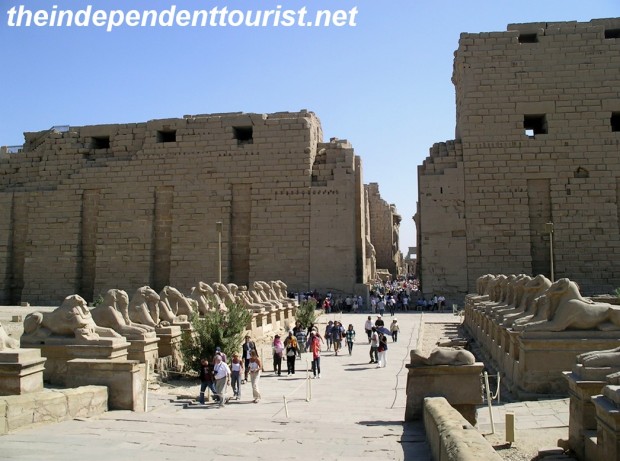
Entrance to Karnak along the Avenue of the Sphinxes (which runs all the way from Luxor).

Entrance to Karnak along the Avenue of the Sphinxes (which runs all the way from Luxor).

Karnak is Egypt’s greatest temple complex and is considered the most important Pharaonic site after the Pyramids of Giza. It was also the most important place of worship in Egypt from approximately 1500 – 1000 BC. It was called “Ipet-Isut” meaning “The Most Perfect of Places.” Karnak was built over a period of about 1,300 years, starting around 2125 BC.

Remants of the original paintings in the Great Festival Hall of Tuthmosis III.

Remants of the original paintings in the Great Festival Hall of Tuthmosis III.

During the reign of Ramses III, 80,000 people worked at or on the complex as laborers, servants, guards, priests and many other functions.

The huge Hypostyle Hall at Karnak.

The huge Hypostyle Hall at Karnak.

Note the size of the people in the distance - Karnak Temple is on a huge scale.

Note the size of the people in the distance – Karnak Temple is on a huge scale.

Karnak's Sacred Lake, where priests purified themselves.

Karnak’s Sacred Lake, where priests purified themselves.

Temple of Ramses III at Karnak.

Temple of Ramses III at Karnak.

The scale of the site (about a square kilometer) is massive and there’s a lot to explore here. Be sure to take the time to go to some of the outer ruins. Karnak is just 2 kilometers north of Luxor (see my post on Luxor here), also on the east bank of the Nile. Both Luxor and Karnak can be visited in one day.

Statues of Karnak at night.

Statues of Karnak at night.

There is an evening sound and light show that was quite good. The show included walking through the massive complex at night, which was a blast and gave the place an entirely different feeling.

Sources: Information at Karnak Temple, DK Eyewitness Travel Egypt, Lonely Planet Egypt.

Overlooking the Karnak Temple Complex and Sacred Lake at night.

Overlooking the Karnak Temple Complex and Sacred Lake at night.

Visiting Luxor, Egypt

About 400 miles (640 km) south of Cairo sits the city of Luxor, on the Nile River. This was one of my favorite spots in Egypt, since there is so much to do here. We arrived by overnight train from Cairo. We didn’t get much sleep on the train, but the sleeper car accommodations were fine and it was a fun way to travel at least once.

Arriving in Luxor after an overnight ride from Cairo.

Arriving in Luxor after an overnight ride from Cairo.

The interior of our sleeper car for the overnight ride to Luxor from Cairo (there is a bed that folds down above the couch).

The interior of our sleeper car for the overnight ride to Luxor from Cairo (there is a bed that folds down above the couch).

Luxor makes a good base for exploring the region. There is a lot to do in this area, we spent 4 days and could have easily spent more.  For a map of places we visited in Egypt, click here.

Luxor is on the east bank of the Nile, and in addition to the temple at Luxor, the huge Karnak temple complex is just two kilometers north along the Corniche (I will do a separate post on Karnak). There are lots of restaurants along the Corniche, and it’s fun to sit outside in the evening watching the sun set over the Nile. You can walk or get a carriage (bargain hard!) or bicycle to take you between the two temples.

My sister, brother in-law and father in-law taking a ride from Luxor to Karnak.

My sister, brother in-law and father in-law taking a ride from Luxor to Karnak.

Just across the west bank of the Nile is the Valley of the Kings, among many other tombs and temples. A bit farther afield, but doable by day trips, are the temples of Dendara (north) and Edfu (south). This post will concentrate on Luxor itself.

Luxor Temple

The temple sits close to the bank of the Nile and is in the heart of the town.

The First Pylon, or entrance to Luxor Temple.

The First Pylon, or entrance to Luxor Temple.

It dates to the time of Amenhotep III (who reigned 1390 – 1352 BC) and was already a tourist site by the time of the Greeks and Romans!

Statues of Ramses II, in the Courtyard of Ramses II.

Statues of Ramses II, in the Courtyard of Ramses II.

The Colonnade of Amenhotep III at Luxor Temple.

The Colonnade of Amenhotep III at Luxor Temple.

The temple site was rediscovered and excavated in 1881, having been covered by sand and silt over the centuries. A small village had sprouted up on top of the temple and even today there is a mosque from this time still enclosed within the temple ruins, an odd juxtaposition.

A chamber of the Luxor Temple with hieroglyphic writings.

A chamber of the Luxor Temple with hieroglyphic writings.

The Avenue of the Sphinxes, which connected Luxor with Karnak.

The Avenue of the Sphinxes, which connected Luxor with Karnak.

I strongly suggest visiting the temple at Luxor first and then visiting Karnak. Luxor is great, but the scale and size of Karnak is so massive, it makes Luxor almost seem puny, so work your way north. Also, Luxor Temple is lit up at night and is quite striking. Be sure to visit then too.

Luxor Temple at night.

Luxor Temple at night.

Taking a carriage ride through the markets of Luxor.

Taking a carriage ride through the markets of Luxor.

A local market in the outskirts of Luxor.

A local market in the outskirts of Luxor.

Both temples can be easily seen in a day, leaving time to wander through the interesting markets in Luxor and maybe taking a dip in your hotel’s pool afterwards.

Exploring Dahshur and Saqqara – Egypt as it was a Hundred Years Ago

If you’d like to get away from the crowds in Cairo, and feel almost like you’re an early explorer in Egypt, take a short trip to Dahshur and Saqqara. These are “don’t miss” sights and an easy day trip (the furthest site, Dahshur, is about 23 miles south from Cairo, we hired a driver and van from Cairo to take us to these sights).

Dahshur

Dahshur originally contained 11 pyramids, and the oldest are the main attractions. The Red Pyramid and the Bent Pyramids were built around 2600 BC, making them slightly older than the pyramids of Giza. They are almost as large as the more famous pyramids at Giza, both are only about 14 feet shorter than the Pyramid of Khafre (the 2nd highest pyramid at Giza). They were the first “true” pyramids the Egyptians built.

The Red Pyramid - picture perfect with a camel!

The Red Pyramid – picture perfect with a camel!

The Bent Pyramid was built first, and the builders learned during construction that they had to lessen the steepness of the angle of the sides due to stability issues and the adjustment gives the pyramid its unique shape.

The Bent Pyramid - not accessible to tourists.  The angle was reduced from 54 to 43 degrees due to stress and instability.

The Bent Pyramid – not accessible to tourists. The angle was reduced from 54 to 43 degrees due to stress and instability.

The Red Pyramid is open to the public, the Bent Pyramid is not, since it is on a military reservation.  I loved visiting the Red Pyramid—it looks untouched with sand still covering the huge stone blocks part way up the sides and inside we had the interior chambers all to ourselves.

The corbelled ceilings in the Red Pyramid chambers. Hard to get a good perspective with a photo.

The corbelled ceilings in the Red Pyramid chambers. Hard to get a good perspective with a photo.

The entrance to the Red Pyramid is in the distance.

The entrance to the Red Pyramid is in the distance.

Saqqara

Just about 6 miles north of Dahshur is Saqqara, the burial site for the ancient city of Memphis, just a short distance away. This was a burial ground for 3,500 years, and was largely buried in sand until the mid-1800’s. Saqqara is home to the Step Pyramid, built in 2650 BC, and it is the oldest stone monument in Egypt and quite possibly the world.

My in-laws in front of the Step Pyramid. The pyramid's interior is not open or safe enough for visitors.

My in-laws in front of the Step Pyramid. The pyramid’s interior is not open or safe enough for visitors.

The Step Pyramid was part of a progression in construction technology that led to the smooth-sided, near perfectly-dimensioned pyramids of Dahshur and Giza just a hundred years later.

The entrance to the Tomb of Mereruka, one of the many tombs at Saqqara.

The entrance to the Tomb of Mereruka, one of the many tombs at Saqqara.

Inside the Tomb of Mereruka, there are 32 chambers in this tomb.

Inside the Tomb of Mereruka, there are 32 chambers in this tomb.

Inside the Pyramid of Teti at Saqqara (about 2300 BC) - note the Pyramid Texts on the walls.

Inside the Pyramid of Teti at Saqqara (about 2300 BC) – note the Pyramid Texts on the walls.

Saqqara is a huge site, you will have to pick and choose what you see, and some tombs may be closed on a rotating basis. There were a few tour buses here, but not many, and since the site is spread out, you may find yourself enjoying the tombs on your own. Be prepared to stoop, crawl, and get a bit dusty in entering some of the tombs – part of the fun!

The Pyramids of Abu Sir, looking north from Saqqara. The most northern one, Pyramid of Sahure, was open to tourists at the time, not sure if it still is.

The Pyramids of Abu Sir, looking north from Saqqara. The most northern one, Pyramid of Sahure, was open to tourists at the time, not sure if it still is.

References: Lonely Plant Egypt and DK Eyewitness Travel Egypt

Giza Plateau – Home to the Greatest Wonder of the World

Regardless of which list of the “Wonders of the World” you consider your favorite or the most accurate (my son and I have argued about this), the Pyramids of Giza have to be on every list. For most tourists flying into Cairo, Egypt the first sight you see as your plane turns to make its approach into the Cairo International airport are the Pyramids at Giza. They look a bit surreal from the air, and I could hardly believe my eyes, seeing these massive structures for the first time. The scale and magnificence of the Pyramids of Giza pretty much defy description.

This photo of me by the Great Pyramid of Khufu (or Cheops) puts into perspective how massive these structrues are.

This photo of me by the Great Pyramid of Khufu (or Cheops) puts into perspective how massive these structrues are.

We still don’t really know how the ancient Egyptians (more accurately their slaves) managed to build these structures, with almost perfect engineering strength and accuracy. Built with stone blocks that weigh 2.5 to 15 tons, they have been standing almost 5,000 years. The greatest difference in the length between the four sides of any pyramid is 2 inches.  The largest pyramid is 450 feet high.

The Great Pyramid. 450 feet high. The haze is the smog of Cairo - which was very bad on the day of our visit.

The Great Pyramid. 450 feet high. The haze is the smog of Cairo – which was very bad on the day of our visit.

All this said, Giza was probably my least favorite spot of the places we visited in Egypt simply because the tourist crowds and smog of Cairo made our visit a little less appealing.  My favorite pyramids were south of Giza and Cairo, in Dahshur and Saqqara, which I will cover in another post. The main sights at Giza (which is just south of the Cairo suburbs), include the three large pyramids made so famous in many pictures and the Sphinx sculpture.

My in-laws at the Sphinx (Great Pyramid of Khufu in the background).

My in-laws at the Sphinx (Great Pyramid of Khufu in the background).

The three large pyramids are: The Great Pyramid (also known as the Pyramid of Khufu or Cheops), Pyramid of Khafre (Khufu’s son), and the relatively smaller third pyramid called Menkaure, who was Khafre’s successor).

The third of the great pyramids, Pyramid of Menkaure. It's quite a distance from the other two to this one (the little pyramid at the left is one of his queen's tombs).

The third of the great pyramids, Pyramid of Menkaure. It’s quite a distance from the other two to this one (the little pyramid at the left is one of his queen’s tombs).

These pyramids were built as tombs during 2600 – 2100 BC, making them over 4,500 years old. These were not the first pyramids built in Egypt, the oldest is the Step Pyramid (King Djoser’s Pyramid) in Saqqara (2665 BC). While these pyramids are the main attractions at Giza, there are other less-visited sites such as the much smaller Queen’s pyramids which are more intimate and fun – very few tourists visit these tombs, which are near the largest (Great) Pyramid.

In front of the Queen's pyramids next to the Great Pyramid.

In front of the Queen’s pyramids next to the Great Pyramid.

The Giza site is very spread out and somewhat confusing – there is no signage to speak of and I got differing directions as we tried to find a few other tombs (such as the Tomb of Khentkawes).

I believe this is the Tomb of Khentkawes, which was closed.

I believe this is the Tomb of Khentkawes, which was closed.

At the time we visited a few years ago, it was possible to only visit one pyramid on a given day (they also rotate closures), and we were able to visit the Pyramid of Khafre, the 2nd largest (slightly smaller than Great Pyramid, even though it looks larger).

My mother-in-law and wife in front of the Pyramid of Khafre. It's the only one with a bit of the brillant outer limestone layer left at the top.

My mother-in-law and wife in front of the Pyramid of Khafre. It’s the only one with a bit of the brillant outer limestone layer left at the top.

I could not get a picture inside this pyramid, and the tunnel is very long and steep.  Be prepared to stoop as you climb the whole tunnel length. It is also humid and stuffy in the main room.

Climbing out of the Queen's Pyramid, giving an idea of what the access tunnels are like.

Climbing out of the Queen’s Pyramid, giving an idea of what the access tunnels are like.

There really isn’t much to see, other than the sarcophagus of the Pharaoh Khafre, but it’s one of those things you have to do!  If you’re claustrophobic it’s probably a good idea to stay outside.  For an overview of places we visited in Egypt, click here.

My brother-in-law doing the touristy thing (why not?) in front of the Pyramid of Khafre.

My brother-in-law doing the touristy thing (why not?) in front of the Pyramid of Khafre.

References: DK Eyewitness Travel Egypt, Lonely Plant Egypt.