Ireland

Ireland Day 8 (of 8): Glendalough and Dublin

On our last day in Ireland we visited the scenic Glendalough monastery ruins and Dublin.

Glendalough

Glendalough is 58 kilometers south of Dublin. It is an early Christian monastic site found by St. Kevin in the 6th century. It sits in a beautiful valley with two lakes. The historic ruins include a round tower, stone churches and decorated crosses; most of the buildings date from the 8th to the 12th centuries. Although attacked by the Vikings and English over the centuries, this site survived until the Dissolution of the Monasteries by King Henry VIII in 1539. Since our time was limited, we visited only the lower ruins (near the Lower Lake) and did not make it to the Upper Lake and few remaining ruins there. We enjoyed the beautiful natural setting as well as the historic aspects. Glendalough is part of the Heritage Ireland system. For a map of these locations click here.

St. Kevin’s Kitchen (11th century) and round tower at Glendalough.

The Cathedral and graveyard at Glendalough.

Dublin

We then drove north to Dublin, and tried to make the most of our short time there (we had an unplanned overnight stop in Graiguenamanagh due to a rental car breakdown). Dublin is located on the east coast of Ireland (almost directly west of northern Wales), and the River Liffey goes through the heart of town west to east, not unlike the River Thames in London. I would not call Dublin a beautiful city like Paris, but it definitely has its own character, and interesting neighborhoods. Many of the historical sights are on the south side of the river.

The River LIffey in Dublin, looking east.

Street scene in Dublin.

Our main interest was seeing the Book of Kells, housed at Trinity College (on the south side of the River Liffey). Trinity College was founded by Queen Elizabeth I in 1592. The Book of Kells is a richly decorated artistic masterpiece. The manuscript (680 pages) dates from about 806 AD and contains the Four Gospels of the New Testament. It is considered the most important piece of art from the Dark Ages. The Book is kept in a small room in the Treasury of the Library at the University under special glass and lighting to preserve this marvelous work. Next to the Treasury is the Old Library—a 210 ft. long room built in 1732 which contains 200,000 texts on two levels. Unfortunately I could not get pictures of either of these gems.

St. Patrick’s Cathedral, Dublin. “The people’s church” dates from 1270. The Protestant Church of Ireland’s national cathedral.

This cathedral of the Church of Ireland dates from 1186, but was heavily restored in the 1870’s. Lots of interesting historical features, including a huge crypt.

We also walked around the town, visiting Temple Bar (famous pubs and restaurant area), Christ Church Cathedral and St. Patrick’s Cathedral (shown above).

Dublin Castle, with the Record Tower (on right – built in 1226) and Chapel Royal (center – built in 1814). The Record Tower is all that remains of the original castle.

Reference:  DK Eyewitness Travel Ireland 2006

Ireland Day 7: Kilkenny Castle, Jerpoint Abbey and Graiguenamanagh

One of the best towns in Ireland for tourists is Kilkenny. It is considered the loveliest inland city, and is located in the southeast part of the country (for a map showing the location click here). It is a well-kept town with a variety of painted buildings and narrow alleyways. The town has two main historical treasures, Kilkenny Castle at one end of town and St. Canice’s Cathedral at the other.

The 18th century Tholsel (city hall) with a clock tower is the main landmark on the High Street in Kilkenny. It is still used by city councilors today.

Kilkenny Castle sits above the River Nore, and dates from the 12thcentury although it’s been heavily remodeled and restored over the centuries and now is decorated in the finest fashion of the Victorian era (1830’s). It has some great paintings, furnishings and wooden ceilings. It was owned and occupied by the Butler family until the 1930’s (a very influential family dating back to the 1300’s who also owned Cahir Castle, discussed in another post, click here). Access to Kilkenny castle is by guided tour only, which lasts about 1 hour. No video or cameras are allowed inside.

Kilkenny Castle from the north side, which faces the town.

View of Kilkenny Castle from the south side.

At the other end of High Street is St. Canice’s Cathedral. The cathedral dates from the 13thcentury and sits on a hill top above the town. I was impressed with the views of Kilkenny from its hundred-foot high round tower. The cathedral is intact and is considered one of Ireland’s key medieval treasures.

A view of St. Canice’s Cathedral, with the round tower which can be climbed.

A view of Kilkenny from the tower at St. Canice’s Cathedral. There are many old churches in this great city.

We also visited Black Abbey in Kilkenny. A Domincan abbey founded in 1225, and a working monastery today.

About 30 kilometers south of Kilkenny are the medieval ruins of Jerpoint Abbey, a large Cistercian abbey founded in the late 12th century that for some reason is not mentioned in Rick Steves’ Ireland book. The tower and cloister date from the 15thcentury. The sculptured cloister arcade is unusual and quite interesting.

A view of the tower of Jerpoint Abbey from the cloister.

The sculptured cloister at Jerpoint Abbey.

Both Kilkenny Castle and Jerpoint Abbey are part of the Heritage Ireland system, which means you buy a membership card once and don’t have to pay individual entry fees at each site which is part of the system.

The town of Graiguenamanagh was NOT on our itinerary, but a rental car breakdown (my first ever) in this town caused us to spend the night here. We actually enjoyed our overnight stop in this little town on the Barrow River. This was a chance to experience a quiet little Irish village, just a little ways east of Jerpoint Abbey.

The town of Graiguenamanagh on the Barrow River.

Ireland Day 6: Waterford, Rock of Cashel and Cahir Castle

From Kinsale we drove to Waterford. Waterford is the oldest town in Ireland, located on the River Suir, near the southern coast. Our main reason for visiting Waterford was to go to the world famous crystal factory located on the edge of the town. The factory provides a one-hour tour of the crystal-making process and has a large store. Of course we had to buy something; Robyn bought a crystal nativity set. We also visited Reginald’s Tower, the oldest surviving civic urban building in Ireland.  Reginald’s Tower was part of the old town’s defenses, built in the late 1100’s. It was used as a mint, prison and military store, and now houses an exhibition on the history of the area. For map of sites visited in Ireland, click here.

Reginald's Tower in Waterford. Dates from the 1100's.

From Waterford, we drove northwest 80 kilometers to the medieval site of the Rock of Cashel, standing over the town of Cashel. It was extremely windy and rainy that day (in mid-March), with the rain coming at us horizontally on the Rock, but we enjoyed our visit nonetheless.  The Rock contains a collection of buildings from the 12th, 13th and 15th centuries.  It was the seat of the Kings of Munster who ruled much of southern Ireland from the 5th century to the 12thcentury. St. Patrick baptized King Aengus here in 450 AD.

Cormac's Chapel from the south side. The first Romanesque church in Ireland, consecrated in 1134. There are a few faint frescoes inside.

The site was turned over to the Catholic Church in the 1100’s as a strategic move to favor the Church and keep the site out of the hands of rival clans. The buildings and ruins include a Romanesque chapel (Cormac’s Chapel), a Gothic cathedral, archbishop’s house (or castle), round tower (the oldest stone structure on the site, 92 ft high), graveyard and other stone monuments. The dormitory building (Hall of the Vicar’s Choral) contains a restored medieval wood roof, visitor’s center and museum.  If you like medieval history and buildings, this is one of the greatest sites in Europe.

The imposing Rock of Cashel as viewed from the north.

A view of the graveyard and round tower on Rock of Cashel.

A view of the round tower and north transept of the cathedral on Rock of Cashel.

From Cashel, we drove to Cahir, to visit Cahir Castle, located 17 kilometers south of Cashel. Cahir is one of Ireland’s largest and best preserved castles, and yet seems to be somewhat unknown to tourists. It is located on a rock island in the River Suir, in the heart of the town of Cahir.  It was built in the 13th century, and expanded in the 15th and 16thcenturies. It was granted to the Butler family by the English crown in 1375, and stayed in the ownership of the family until 1964. There are lots of rooms to explore in this castle.

Cahir Castle on the River Suir.

View of Cahir Castle.

Reginald’s Tower, the Rock of Cashel and Cahir Castle are all part of the Heritage Ireland system.

References: Rick Steve’s Ireland 2007 and DK Eyewitness Travel, Ireland 2006.

Ireland Day 5: Blarney Castle, Kinsale and Charles Fort

Blarney Castle is near Cork, in southwest Ireland.

From Kemare and the Ring of Kerry, we headed southeast to Blarney Castle (for a map of Ireland see my post “Eight Day Tour of Ireland”). This castle is famous for the “Blarney Stone” which is supposed to endow the “gift of gab” on anyone who kisses it. The stone is at the top of the keep (up 127 steps), and one has to lean backwards over the edge of the wall (see picture below) to kiss it. We didn’t bother to kiss the stone, but everyone else seemed to be doing it! The castle was built in 1446. Underneath the castle there are some tunnels that were interesting to explore, perhaps old secret passages. This castle is not part of the Heritage Ireland system, and so a separate fee is required. There are lovely gardens and well-manicured grounds around the castle. The little village of Blarney is also well-kept.

The lovely grounds of Blarney Castle.

The Blarney Stone is located above the top window, in the parapet wall.

From Blarney, we headed to the south coast of Ireland (via Cork) to the town of Kinsale, known as one of the prettiest towns in Ireland. Kinsale was an important shipping port and naval base, from Middle Ages and through the 1800’s. It was known for making top quality wooden (oak) casks (there used to be plentiful forests of oak in this area), and the wine trade was a major driver of the economy. Desmond Castle is a fortified Norman customs house, and was used to house prisoners in various wars and also American Revolutionary War “rebels” captured at sea—they were chained to the outside of the building as a warning to local Irish who also might want to rebel against British rule. There are some interesting exhibits in the Castle about the wine trade and the history of the area. It is part of the Heritage Ireland system.

A view of Kinsale harbor.

Desmond Castle in Kinsale.It once housed 600 prisoners during the Napoleonic wars (where did they all fit?).

Just two miles from Kinsale is Charles Fort, a massive star-shaped fortress built in the 1670’s which was modified over the next couple of centuries. The fort was meant to protect Kinsale from naval attack, but was vulnerable to land attack, which happened in 1690. The British occupied this fort until Irish independence was achieved in 1922. This fort was really a mini-city, and feels like a “ghost town” with many buildings still standing. The fort is also part of the Heritage Ireland system.

A view of the coast from the massive walls of Charles Fort.

A view of the barracks and other buildings at Charles Fort.

Another view of Charles Fort and Kinsale harbor.

Close to Kinsale is the town of Cobh, which we did not have time to visit. The Titanic made a last stop at Cobh before heading across the Atlantic on its fateful voyage to America.

References: Rick Steves’ Ireland 2007 and DK Eyewitness Travel, Ireland, 2006.

Ireland Day 4: Ring of Kerry

The rugged Atlantic coastline of the Ring of Kerry, Ireland.

Located on the southwest coast of Ireland, the famous Ring of Kerry is one of Ireland’s most popular attractions (it’s called the “Ring of Kerry” since Iveragh Peninsula is part of County Kerry). Like the Dingle Peninsula, it provides the tourist with a great combination of historical sights and natural scenery. On our fourth day in Ireland, we took the 120 mile drive around the peninsula.

Kenmare

Our B&B in Kenmare

Our base for exploring this area was the little town of Kenmare, south of Killarney, and a good jump-off spot for touring the Ring (see map below). Many people stay in Killarney to visit this part of Ireland, but if you prefer a little quieter location, try Kenmare. We stayed in a great B&B, just outside the town. No problem finding good food here. We found an excellent Italian restaurant right on the main street. In the town of Kenmare, just off Market Street is “Druid’s Circle” a prehistoric stone ring of 15 stones associated with human sacrifice.

The Druid stone circle in Kenmare. Note the altar in the middle right.

Ring of Kerry

Since we were visiting in late March, crowds were not a problem on the Ring road, but from what we understand, there are LOTS of tour buses in the summer, so be prepared for slow driving and a lot of people. Rick Steves recommends going clockwise on the Ring (against the tour bus flow) in order to avoid the crowds if visiting in the summer, and this is probably a good idea.  We went this way even though the traffic was light during our visit.

An old castle-home off the road on the Ring of Kerry.

Below are a few of the sites we saw on this road trip.

Ring Forts

We visited Staigue Fort (on the south side of the peninsula), and the Cahersiveen forts (on the north side of the peninsula, near the town of Cahersiveen). These forts were built between 500 BC and 300 AD.  Not much is known about the builders, but apparently they were defensive shelters in times of tribal warfare.  They were built without mortar, and are large structures—walls are 12 feet thick at the base and up to 20 feet high. All of these forts are just a mile or two off the main route.

Exterior view of Staigue Ring Fort.

Inside Staigue Ring Fort.

The huge ring fort near Cahersiveen.

Skellig Michael

At the western end of the Ring of Kerry is the jump-off spot to Skellig Michael, one of the three prominent “St. Michael” monasteries in Europe (the others being Mont St. Michel in Normandy, France, and St. Michael’s Mount in Penzance, England). St. Michael is the patron saint of high places, hence why these three sites are named after him. The downside of visiting Ireland in March is that no boats were operating out to Skellig Michael (about 10 miles off the coast). They do not begin service until after Easter, and even then, getting a boat is iffy, and dependent on the weather. Monks lived on Skellig Michael from 600 AD to the 12thcentury. If you are going to Skellig Michael, you will need to stay in Portmagee overnight, or awake VERY early and drive approximately 60 miles from Killarney or Kenmare  out to Portmagee.

Skellig Michael in the distance from the western edge of the Ring of Kerry.

Ballycarberry Castle

Close to Cahersiveen is this ruined, ivy covered castle, which is a fitting symbol of Ireland.  We just happened to see a sign pointing to the castle and decided to check it out, one of the benefits of having our own car.

The ivy covered ruins of Ballycarbery Castle.

Ross Castle

Near Killarney is Ross Castle. It has an imposing setting right on the shore, on an isthmus in Lough Leane, which separates this large lake into two parts. The castle was built in 1420.  Inside the castle several rooms provide great examples of medieval construction methods for ceilings, showing the use of wood lath, plaster and the curvature of the wooden frame to provide strength.

Ross Castle, hear Killarney.

Killarney is in such a unique perfect setting with mountain peaks (over 2000 feet high), lakes, Killarney National Park, and the Ring of Kerry.  No wonder this is such a popular tourist destination.

References: Rick Steves’ Ireland, 2007, and DK Eyewitness Travel, Ireland, 2006.

Key sights on Ring of Kerry, Ireland.

Ireland Day 3: Dingle Peninsula

The narrow road that winds around Dingle Peninsula.

The farming country of Dingle Peninsula. There are more sheep than people in this remote part of Ireland!

From the town of Dingle, we drove around the peninsula counter-clockwise.  We had most of the road and stopping points to ourselves (we were there in late March), and enjoyed the great views of the rugged coast and the now uninhabited Blasket Islands (the village on the main island is now a ghost town). The government thought it best to move the last of the residents from the Blaskets to the ‘mainland’ in 1953. There are also some interesting historical sites in this remote and windswept part of the Emerald Isle, which provides a feel for the Ireland of yesteryear.  A drive around the end of the peninsula with stops will take about 3 hours, although it is only about 30 miles. This part of Ireland is Gaelic-speaking (yes, English is spoken too).

The Dingle Peninsula, Ireland

The Ring of Kerry to the south is more famous and well-traveled, but the scenery on the Dingle Peninsula is beautiful and a bit less touristy.

Here is a pictorial tour, driving west from the town of Dingle…

The "Beehive Huts" on Dingle Peninsula - thought to be early Christian huts built for pilgrims visiting the area.

The beautiful coastline, with the green manicured hills and very blue waters of the Atlantic:

Coming up to Dunmore Head, the westernmost point in Europe.

Dunquin Harbor, on the Dingle Peninsula coastline. In the right side of the picture there is a ramp for a ferry that goes out to the Blasket Islands. Farmers from the Blasket Islands would dock here (until residents were moved off the islands in 1953), and hike 12 miles to the town of Dingle to sell their produce. This area (but not the Blasket Islands) was affected by the potato famine of 1845.

Some interesting historical sites include the ancient churches:

The Church of Kilmalkedar, a 12th century Irish Romanesque church, with a very old cemetery that pre-dates this church.

The vertical stone (below) that Robyn and I are touching is called an ogham stone (900 years older than the Church of Kilmalkedar), and has a script carved onto it that was used in the 3rd to 7th centuries. The stone marked a pre-Christian grave, and a hole in the top of the stone (where Robyn and I are touching thumbs) was a place where people would come to covenant with one another, standing on the graves of their ancestors.

The ancient ogham stone.

The Gallarus Oratory, which is 1,300 years old, is a marvel of watertight stone construction. The stonework is dry-stacked (no mortar).

The Gallarus Oratory, built about 700 AD.

Historical information references: Rick Steve’s Ireland 2007 and DK Eyewitness Travel, Ireland, 2006.

Ireland Day 2: From Limerick to Dingle Peninsula

On our second full day in Ireland we visited King John’s Castle in Limerick, the Village of Adare (and  Desmond Castle), and Ardfert Cathedral, before making our way to the town of Dingle on the Dingle Peninsula.

Our stops on Day 2

Limerick is not a real tourist destination; it’s more of working city, and the third largest in Ireland. King John’s Castle near the center of town looks better from the exterior than the interior. The interior is mainly set up for modern exhibits. The castle was built in 1200 by King John (of Magna Carta fame). It does have a great setting on the River Shannon.

King John’s Castle on the River Shannon

From Limerick we drove south to the little village of Adare, which is considered one of Ireland’s prettiest villages. It is a quaint village with thatched roof houses, with Desmond Castle (often called Adare Castle) on the outskirts, in addition to the famous castle-hotel of Adare Manor, which is one of the “1,000 Places to See Before You Die” in the book by Patricia Schultz (she actually lists 29 sites in the Republic of Ireland, a pretty good share of the 1,000!).

Desmond Castle, Adare

Looking at the Great Hall, Desmond Castle

Ardfert Cathedral is part of the Heritage Ireland system and the Cathedral ruins date from the 12th century, although a monastery was believed to have been founded here in the 6thcentury by St. Brendan the Navigator, who legend says visited the American continent (there is actually some evidence of this in Connecticut, in an archeological site called the “Gungywamp”). There are three medieval churches on the site today, and a short walk away you will find the very substantial ruins of a Franciscan Friary. Ardfert is good for quick stop if you like medieval church buildings. As with many other locations, this site is completely ignored by Rick Steve’s book on Ireland, although he does share some information on St. Brendan.

The intricate Romanesque doorway of the Ardfert Cathedral

Ardfert Cathedral

Franciscan Friary near Ardfert Cathedral

From Ardfert, we drove southwest to the Dingle Peninsula and the town of Dingle, on the southwest side of the peninsula. This drive is quite pretty, with the rolling hills, sheep grazing in the green pastures and views of the sea coast as you get closer to Dingle. A few miles east of Dingle and off the road a mile or so to the south is the little ruin of Minard Castle, a jump-off point in medieval times for sailing to the pilgrimage destination of Santiago de Compostela in northern Spain. This castle is in a cow pasture, and we treaded lightly to avoid any trespassing issues. The castle sits above a beautiful beach (Storm Beach) and bay.

Minard Castle near the town of Dingle

Ireland Day 1: Newgrange, Trim Castle and Bunratty Castle

After arriving in Dublin the prior evening and staying in a B&B close to the airport, we drove north to  Newgrange (about 55 km, near the town of Drogheda) and then southwest to the town of Trim, home of Trim Castle (another 45 km).  Finally, we drove all the way down to Limerick (about 233 km), visiting nearby Bunratty Castle in the late afternoon, and then spent the night in the Limerick area.

Newgrange. This unique burial ground dates from 3200 BC and much of it is intact, having escaped invaders over the centuries until it was discovered in 1699. Excavations took place in the 1960’s. This burial site is 500 years older than the pyramids of Giza, Egypt. It’s hard to get good pictures here, since access is tightly controlled and no pictures are allowed inside. The site consists of an entrance into the mound and a 62 foot long passageway to a small circular burial chamber, with a corbelled stone roof that has kept the chamber dry for 5,000 years. There is a small opening over the entrance door that is aligned such that on Dec. 21st (winter solstice) natural sunlight illuminates the long passageway and all the way into the chamber for 17 minutes—the world’s oldest solar observatory.  Many of the interior stones lining the passageway are decorated with geometric and circular patterns. Since we visited in March, we had no problem gaining access to the tomb (the only way to visit is with a tour guide from the Visitor’s Center), but I understand during the summer the lines can be long, so plan accordingly. There is a shuttle bus from the Visitor’s Center up to the site.  Newgrange is part of the Heritage Ireland system.

The Newgrange burial mound, entrance is on the right side. 3200 BC.

The entrance to Newgrange burial tomb. Note the small opening above the doorway where the sunlight of the winter solstice lights the passageway and tomb. Also, the horizontal stone in front is decorated with ancient geometric designs

Trim Castle.  One of my favorite historical movies is Braveheart, about William Wallace (played by Mel Gibson), the Scottish patriot who fought for Scottish independence against King Edward I in the 1200’s. The castle was used in the movie as a setting for York, England. It was built in the 12thcentury and is the largest Norman castle in Ireland, meant to keep the Irish at bay after the Norman conquest of the British Isles. The tower keep is 70 feet high and has 20 sides, which provided defensive views in every direction.  The castle is set next to the River Boyne, and across the river part of the original town wall also remains. The only way to visit the inside of the Keep is by guided tour, which is twice per hour.  Having been in many castle keeps, we did not take this tour, and just wandered around the castle grounds. Trim Castle is also part of the Heritage Ireland system.

A view of the old city gate and Trim Castle in the distance

A view of Trim Castle from across the River Boyne

The huge walls defending Trim Castle

Bunratty Castle.  Rick Steves (travel book author) says to bypass this castle and adjacent Folk Park. Although this site is a bit touristy, I think it’s worth the visit. The castle was built in the 1400’s and the interior has been restored to the era of the early 1600’s. It’s privately owned (not part of Heritage Ireland). We did tour the interior, which has some unusual chandeliers. Medieval dinners and show are held in the castle, which we debated attending that evening.  However, the cost at the time was about $100/person, and $300 for the 3 of us seemed a bit steep, so we passed up the opportunity. There is also a Folk Park next door to the castle, showing rural life in Ireland at the end of the 19thcentury. You can wander into the shops and houses to get a feel for life during that era.

Bunratty Castle (near Limerick)

References: DK Eyewitness Travel Ireland 2006, Rick Steve’s Ireland 2007.

Eight Day Tour of Ireland

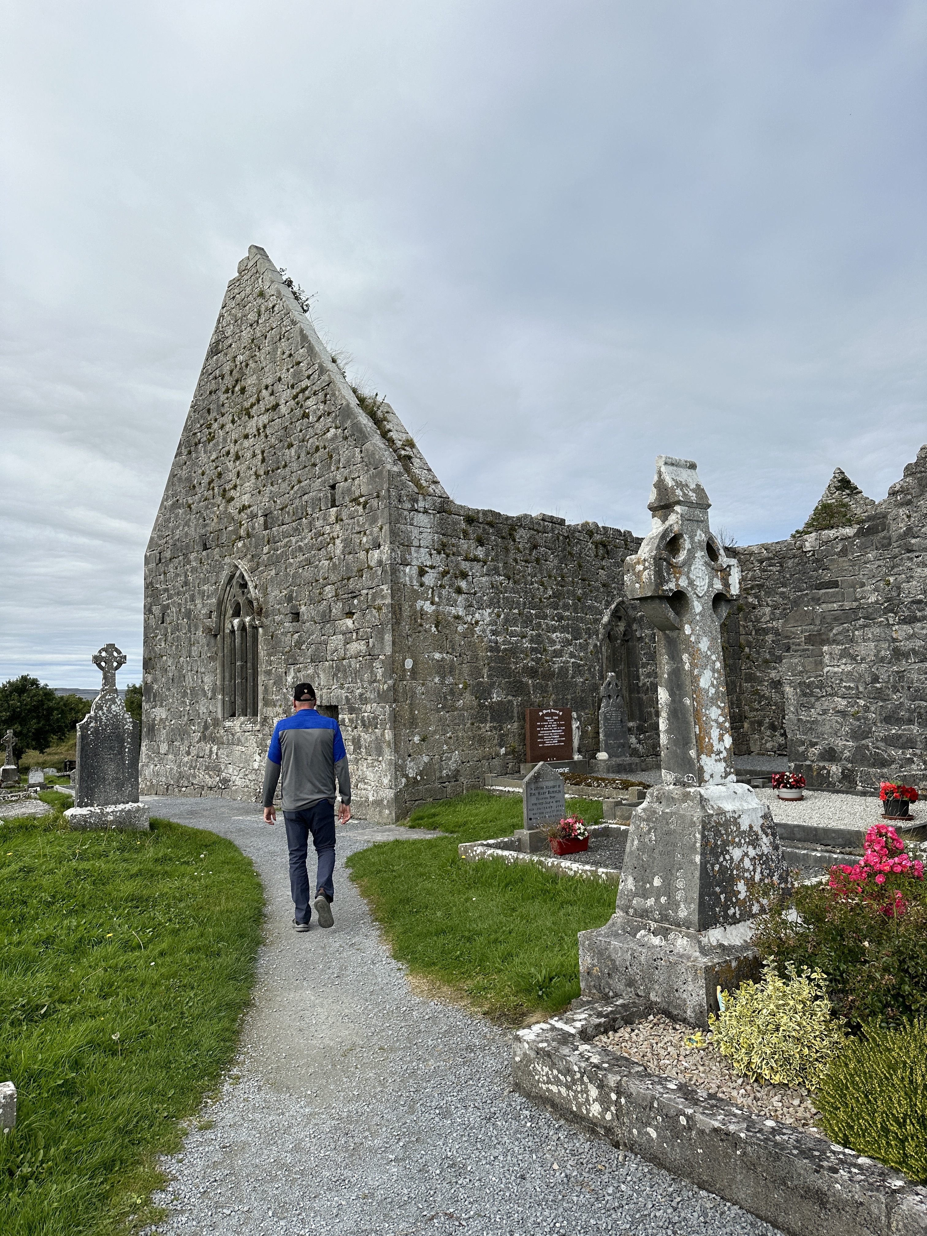
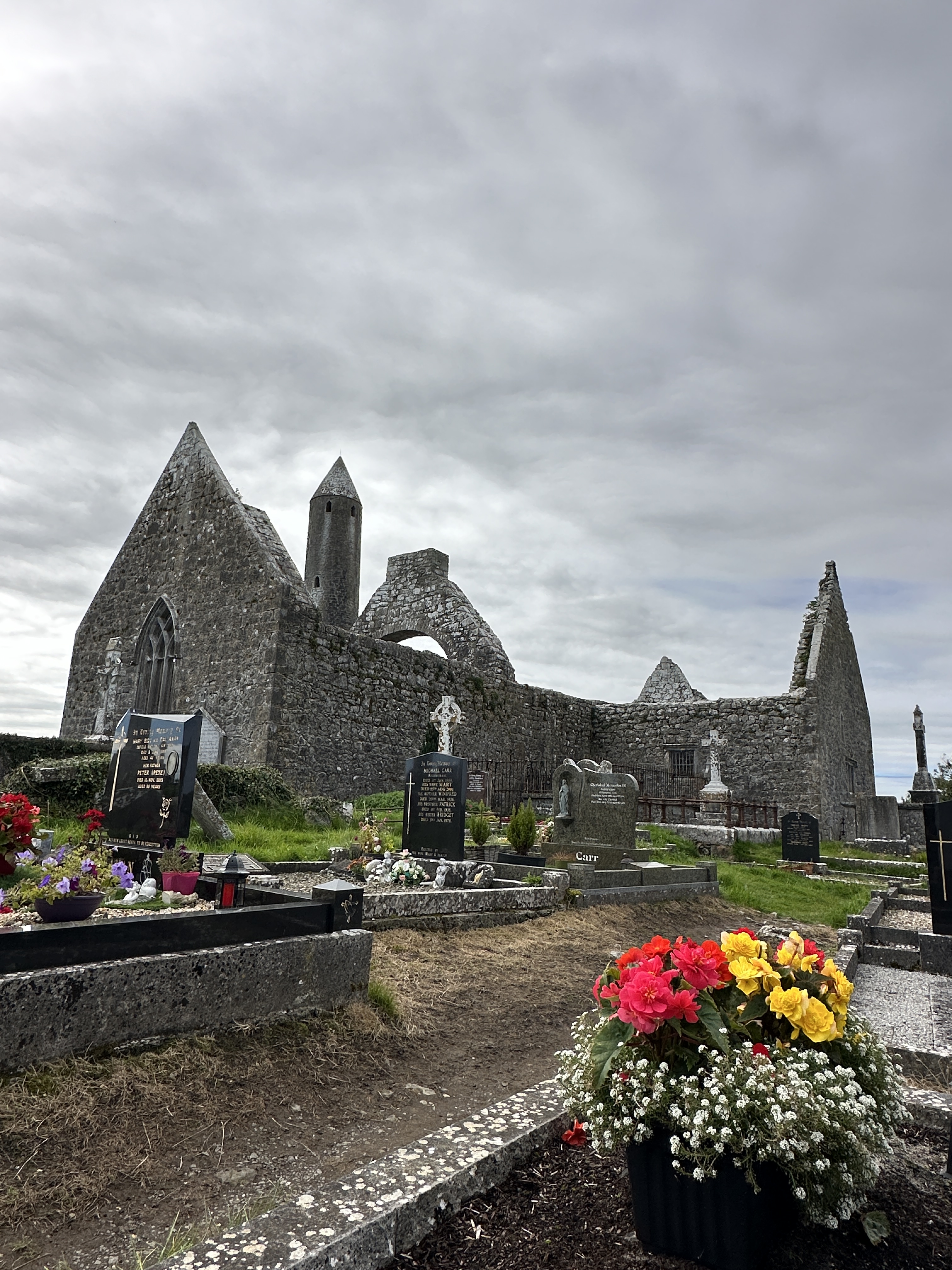
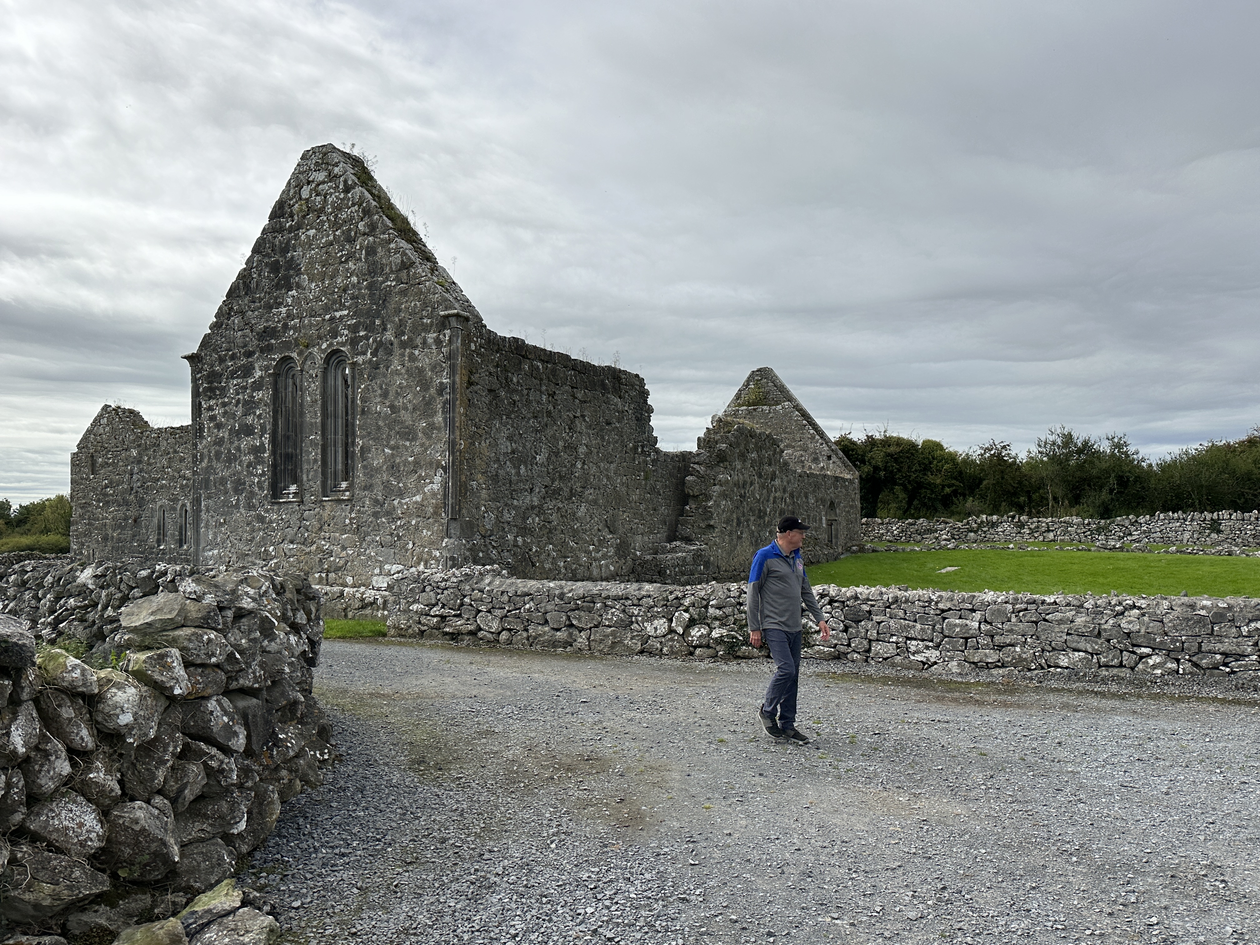
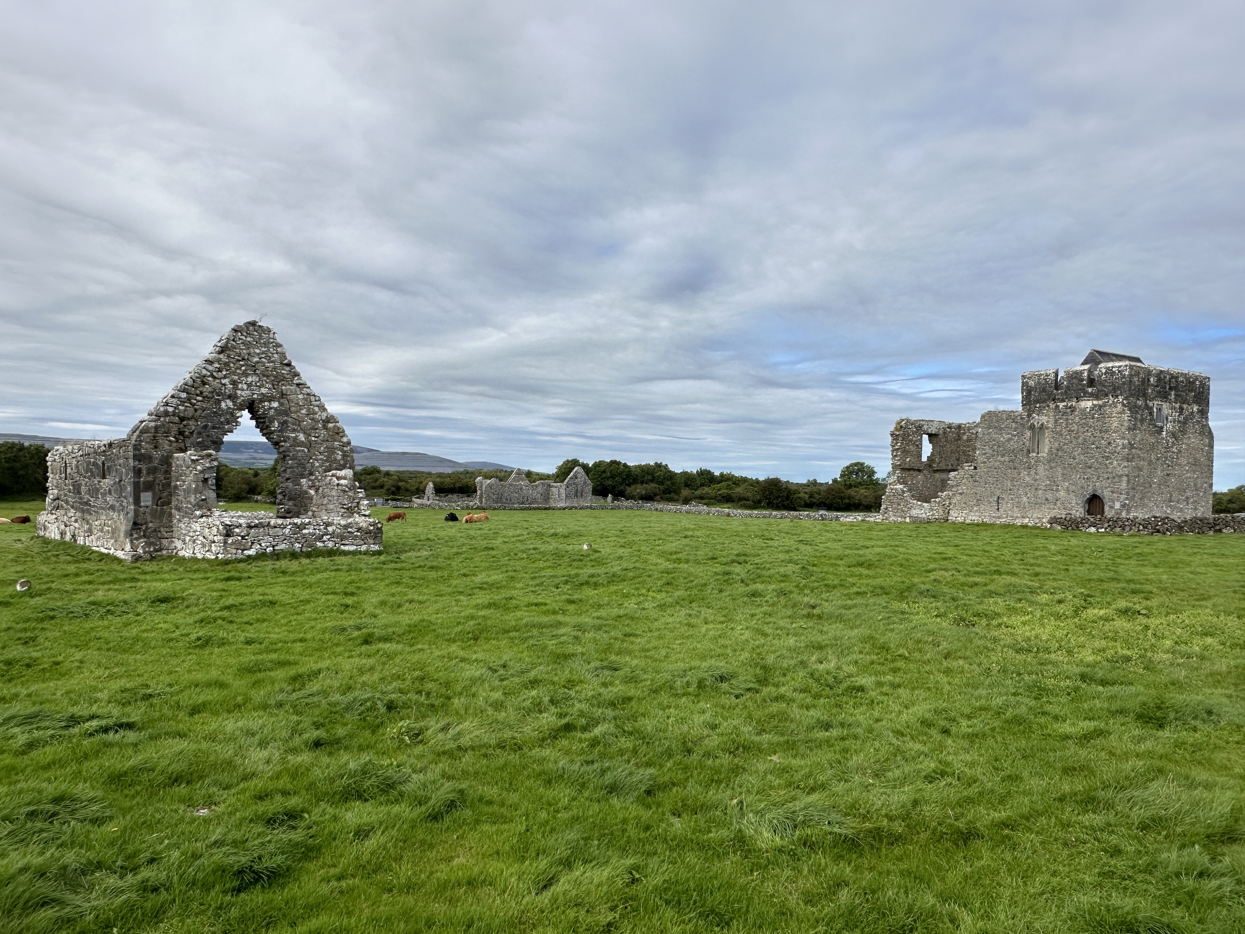
Franciscan Friary near Ardfert. There are many medieval church ruins throughout Ireland.

I suggest considering Ireland as an alternative to the more popular (and crowded) tourist magnet of England. It has just about everything for the European tourist: natural beauty, well-preserved ancient forts and castles, friendly people, hearty food and good infrastructure. We visited Ireland in the month of March, during Spring Break, since it was our son’s high school “graduation trip.” March was a good time to visit, with few tourists and cool but reasonable weather; although the downside is that some sites are not open. We decided to concentrate on southern Ireland. With my love of history, we focused on historical sites and some of the natural beauty of this country.  In future posts, I will provide more detail about our tour locations.

Our tour of Ireland

Our self-guided tour was counter-clockwise from Dublin and covered a lot of ground in 8 days: We flew into Dublin and drove north to Newgrange (prehistoric site from 3200 BC), on to Trim Castle (used in Braveheart), then to Limerick (Bunratty Castle), Dingle Peninsula, Ring of Kerry, Kinsale (close to Cork and Blarney Castle), Waterford (think crystal), Cashel, Kilkenny, Glendalough and finally back to Dublin.

Don’t miss the following:

Killarney and Ring of Kerry.  A classy town and beautiful setting next to high peaks and the Lakes of Killarney. Killarney is the gateway to the Ring of Kerry, which is loaded with historical spots and natural beauty. The western end of the Ring is the jump off point to Skellig Michael, an island monastery dating to 600 AD. I would have killed to get out there, but boats do not go out to the island until after Easter, and even then only when the seas are calm enough to do so.

Coastline of Ring of Kerry

Dingle Peninsula. Some of the bluest water I have seen anywhere was along the coast of this Peninsula just north of the Ring of Kerry.

Blarney Castle.While it is too touristy for my tastes, this is a great castle. I refused to kiss the Blarney Stone (at the top of the castle keep), but if you want the “gift of gab” go for it.

The world famous Blarney Castle

Rock of Cashel.This is one of the great medieval sights in the world, bar none. Home to the kings of Ireland for centuries, it sits on a rock outcropping above the town of Cashel in stunning fashion.

The stunning Rock of Cashel

Glendalough. I love the combination of history and natural beauty. A pristine setting for the monastery among the valleys and lakes, south of Dublin.

The Book of Kells, at Trinity College in Dublin. This richly illustrated book of the Four Gospels was written by monks in 800 AD and is now preserved in this historic university in Dublin.

Some tips for visiting Ireland:

Get a Heritage Ireland Card.  Like English Heritage, this card allows access to many historical sites for one fee. Cards can be purchased at your first site. Visit www.heritageireland.ie for more information.

Cost. Some people are surprised to find out that the Republic of Ireland is on the Euro. It is NOT part of Great Britain (as compared with Northern Ireland). Prices are pretty high in Ireland, although I think the UK is more expensive. Expect to pay about €35 per person for B&B’s. The upside is that Ireland is less visited than Great Britain.

Accommodations. Hotels are few except in the larger cities, and for the most part, Bed & Breakfasts are the norm. We did stay in a couple Travelodge hotels (Waterford and Dublin Airport) with decent, relatively inexpensive rooms. We enjoyed the places we stayed and found the proprietors very welcoming and helpful. Pick a location to work out of for a few days and then move to the next location. Ireland is small, and it’s easy to get many places from one central location.

Our B&B in Kenmare

Transportation. Unless you are part of a tour group, car is the main mode of transportation (driving is the same as the UK, left side of the road). Roads are in good condition, but most country roads are very narrow. There are very few “highways” as we think of them in the U.S.  Trains are possible, but only serve major towns and routes.

Weather. With very few mountains to block weather from the Atlantic, we experienced waves of clouds and showers followed by periods of sunshine.  Expect every type of weather.  We took light rain jackets and rain pants and were glad we did. Umbrellas are almost useless, given the sideways rain showers.