The Wonders of Angkor Archeological Park, Cambodia – Day 1

After getting settled in Siem Reap our first night, we were ready the next morning to hit the ground running and see the magnificent temples of Angkor Archeological Park. It is helpful to have a good map of the main temples when reviewing the post below and preparing for a visit. I thought the map referenced here was excellent. Listed below are the sights we visited on the first day:

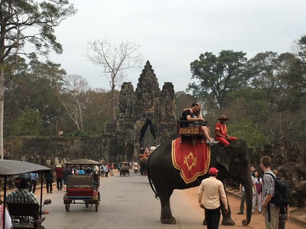
The Royal City of Angkor Thom (Big Angkor).

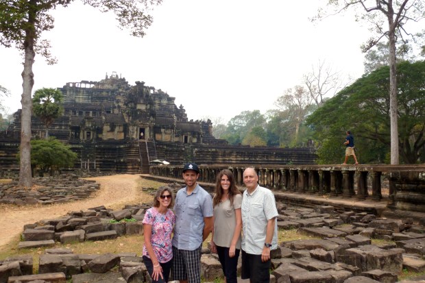
Angkor Thom covers a large area (3 km2) and contains many interesting structures and is second only to Angkor Wat in terms of priority to visit. It is just north of Angkor Wat and as I suggest below, bypass Angkor Wat (for now) and head directly to Angkor Thom. Angkor Thom was a walled and moated royal city, the last capital of the Angkor Empire. Most of the buildings date from the late 12th century to the early 13th century. You can spend much of the day just exploring the structures here:

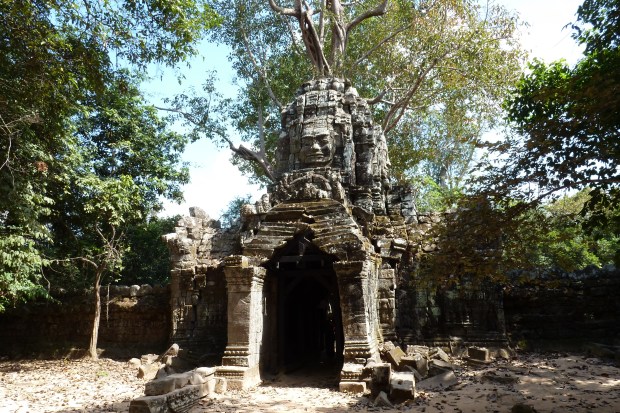
Bayon. One of the most famous temples in Angkor Thom. Its configuration represents a stone mountain and it served as the state temple of King Jayavarman VII.

bayon-58

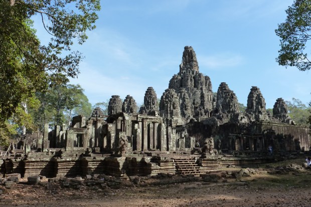
A view of Bayon Temple.

bayon68

One of my favorite views of the towers at Bayon temple.

bayon-34

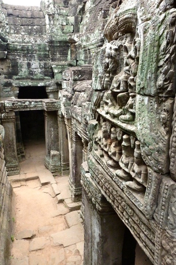
A passageway at Bayon.

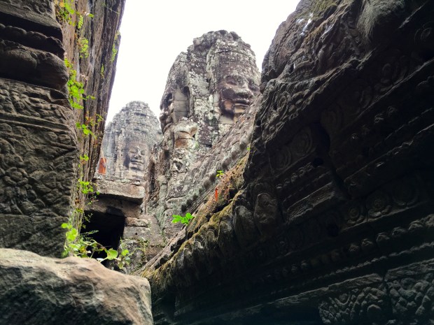
There are 37 existing towers (out of 49 originally), most of which are carved with 4 faces, or in some cases 2 or 3 faces.

bayon-20

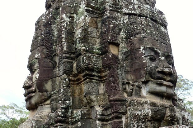
A closeup of the faces at Bayon.

It underwent several renovations under later kings.

Terrace of the Elephants and Terrace of the Leper King. The Elephant Terrace is 300 meters long and dates from the 12th century. It derives its name from the carved elephants on part of the walls. It fronts the Baphoun Temple and provides the backdrop for an impressive Royal City thoroughfare.

terrace-of-the-elephants-4

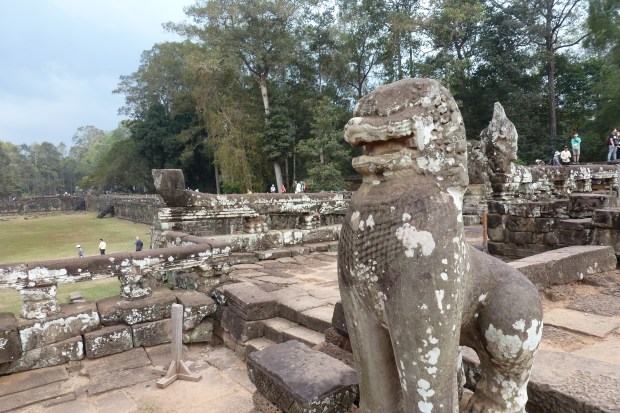
The Terrace of the Elephants.

terrace-of-the-elephants-1

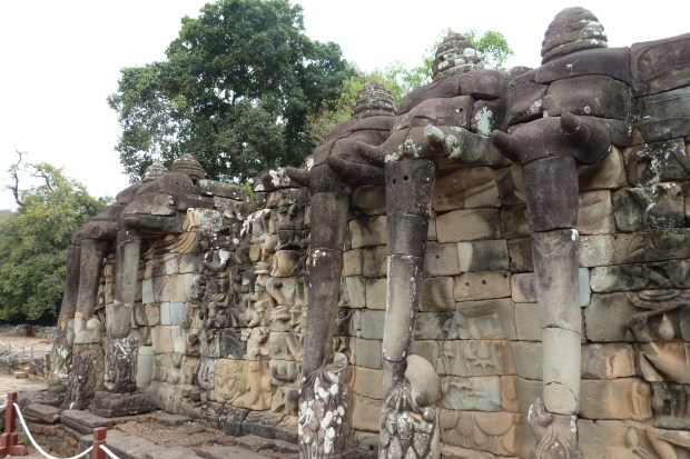
The elephants from which the terrace derives its name.

The Terrace of the Leper King is just north of the Terrace of the Elephants and contains intricate carvings, many found on a hidden double wall that was just excavated in the late 1990’s.

terrace-of-the-leper-king-5

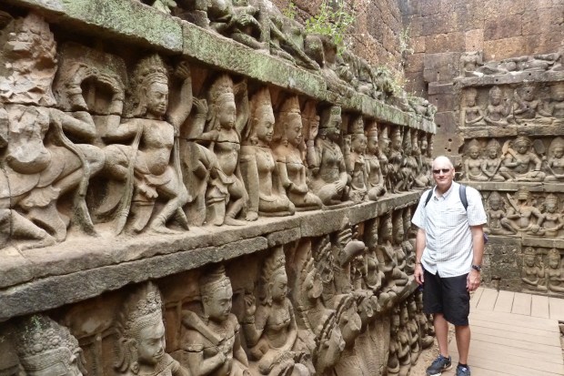
A close-up of the double wall at the Terrace of the Leper King.

terrace-of-the-leper-king-6

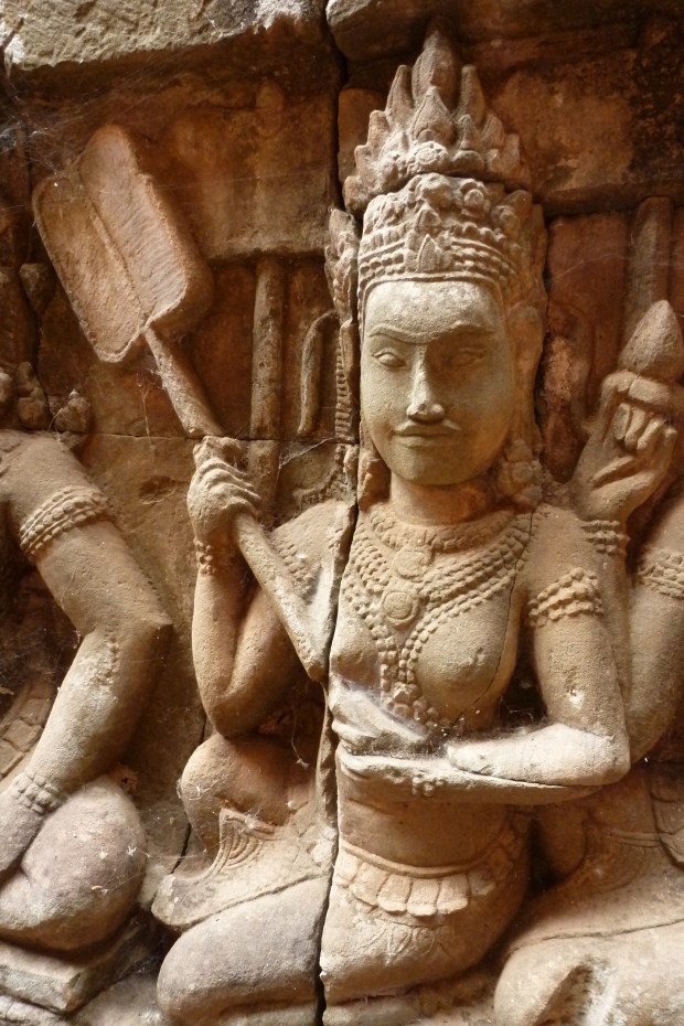
Close up of a carving at the Terrace of the Leper King.

Just east of these terraces are other small towers lined up in a row whose purpose is not clear. To the west of these terraces are the following temples:

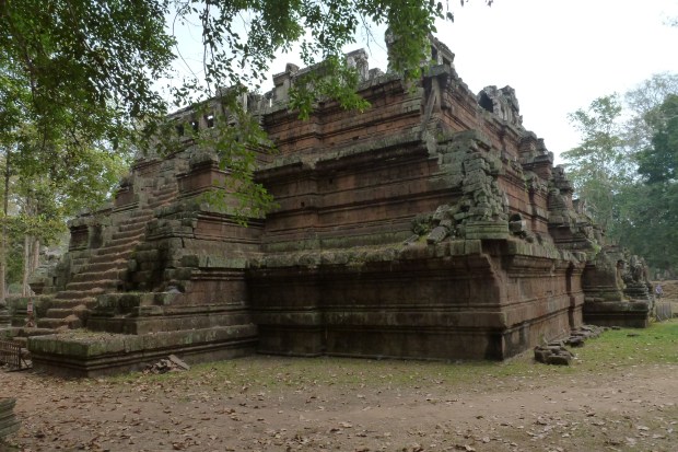
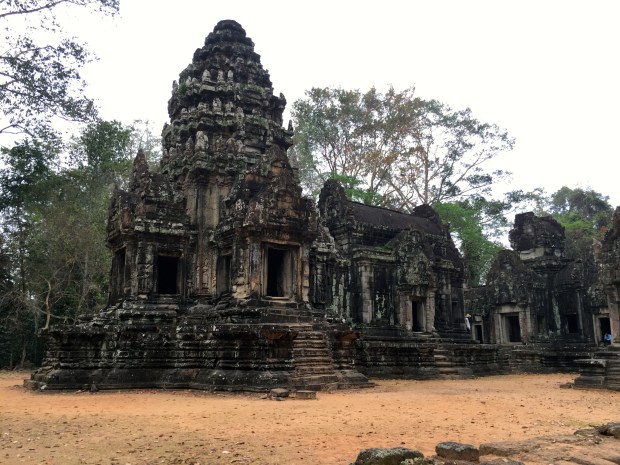
Baphuon. Another state temple, and an earlier (mid 11th century) construction than Bayon. This pyramid temple underwent major restoration and rebuilding over almost a 40 year period.

baphuon-11

A view of Baphuon and the causeway leading up to the temple.

The restoration was interrupted during the Khmer Rouge dictatorship years in the 1970’s, and records regarding the restoration were unfortunately lost, leaving a huge pile of blocks!

baphuon30

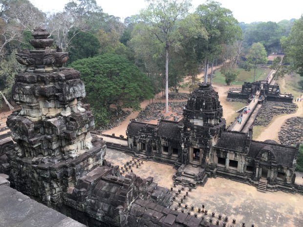
A view from the top of Baphuon.

Phimeanakas. Close to Baphuon, this pyramid temple dates to the mid 10th century, and sits on the site of the Royal Palace, which no longer stands. However, there are enough remnants including walls, gates and pools to give an idea of the grandeur of the palace grounds.

phimeanakas-2

Phimeanakas Temple


baphuon38

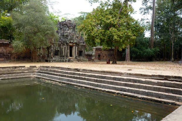
A view of a gate, wall and pool on the Royal Palace grounds near Phimeanakas.

Outside of Angkor Thom.

Just to the east of Angkor Thom are two small but well restored temples, both similar in style to Angkor Wat. Both temples have Hindu and Buddhist themes in their carvings. They also look very similar to each other, but were actually built in different periods. The best news is that they don’t receive a lot of visitors, so they make a peaceful and pleasant stop and a good place to get photos without crowds.

Thommanom. This is the older temple of the two. Built in the 11th century.

thommanom11

Thommanom Temple

Chau Say Thevoda (or Chao Say Tevoda). Directly opposite of Thommanom on the south side of the road leading out of Angkor Thom. From the 12th century.

chau-say-thevoda-1

Chau Say Thevoda Temple.

Ta Keo. Ta Keo is just a bit further east of the two temples above, and different in style from the examples above. Ta Keo was constructed out of sandstone and very plain, without much decoration. It is an older temple, originating in the late 10th century.

ta-keo-8

Ta Keo Temple–the red sandstone is apparent.

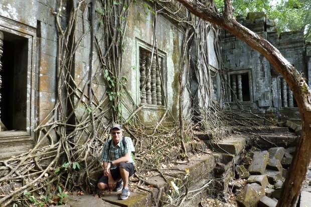
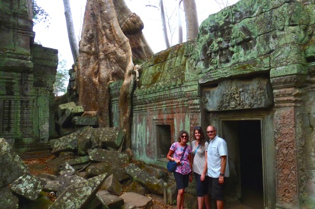
Ta Prohm. Perhaps the most romantic and mysterious temple in the Angkor area, and definitely one of the most famous, having been a filming location for the movie Tomb Raider starring Angelina Jolie.

ta-prohm-12

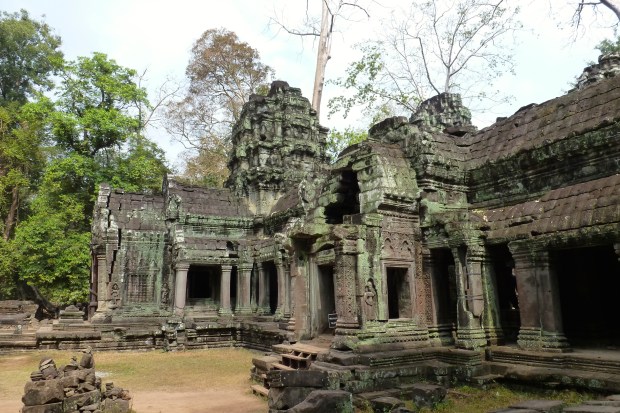
Entrance to Ta Prohm.

ta-prohm-53

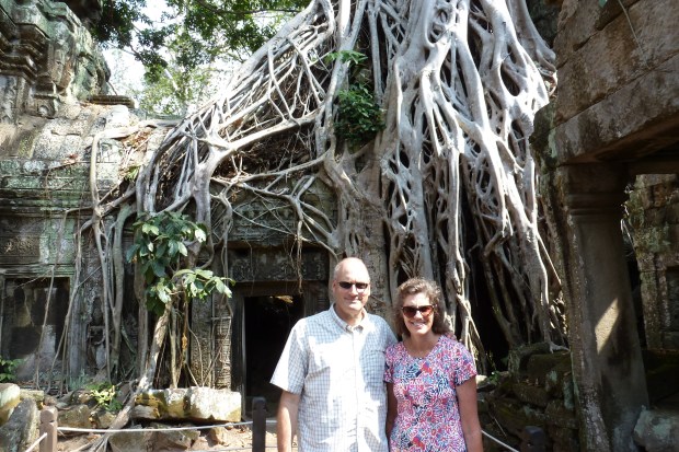
The famous “Tomb Raider” door.

ta-prohm

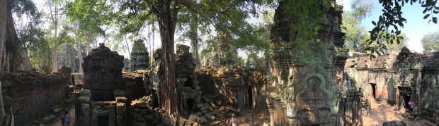
A panorama of the interior courtyard of Ta Prohm.

This temple has purposely been left more or less in its natural ruined state to show what the temples looked like during their rediscovery in the 19th century.

ta-prohm85

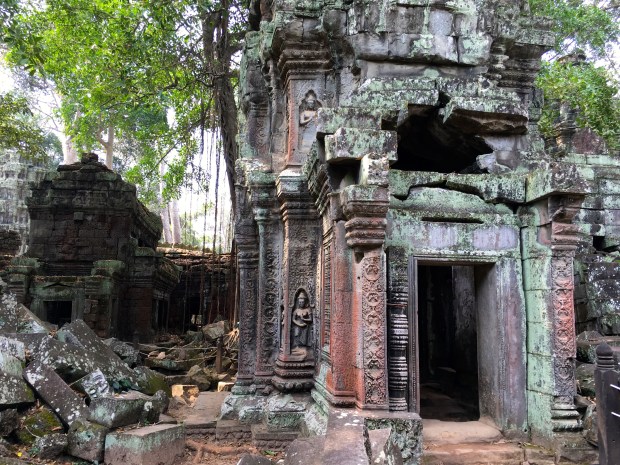
Another personal favorite view of Ta Prohm.

ta-prohm-32

One more view of Ta Prohm. Almost every inch of this temple is a postcard image.

Ta Prohm was built between the mid 12th century and early 13th century. It was a Buddhist monastery, and a very wealthy one at that – controlling 3000 villages and known for its stores of jewelry and gold. Definitely a must-do on any itinerary. Hint: Ta Som, a temple we visited on our 2nd day (my next post), was almost as stunning and far less busy.

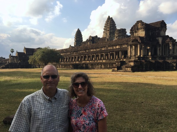
Angkor Wat. The granddaddy of them all and the world’s largest religious monument. We saved a visit to this temple until the afternoon and we were glad we did for two reasons: a) Fewer tourists. Since this is the first temple one comes to after the ticket entrance, most tours stop here first. We came back in the afternoon, and while there were still some tourists, there were no where near the crowds we saw in the morning. b) The view. The typical morning haze and clouds in this region dissipate by the afternoon, and we were left with a glorious temple bathed in perfectly positioned afternoon sunshine.

angkor-wat-24

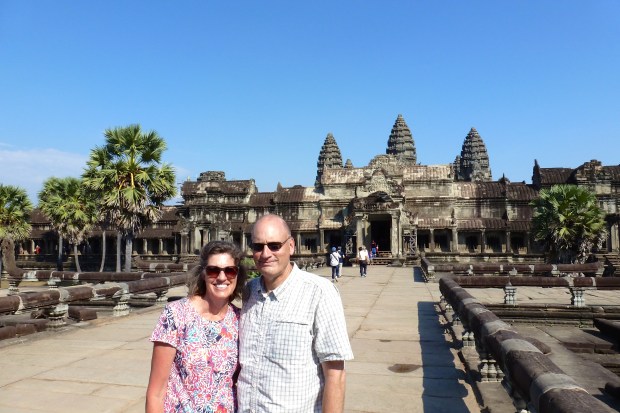
A perfectly blue sky in the afternoon at Angkor Wat.

angkor-wat64

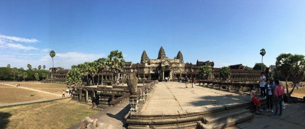
A panorama of Angkor Wat.

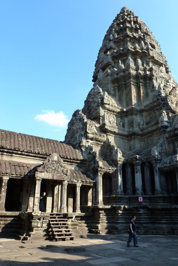
Angkor Wat was a temple-mountain dedicated to the Hindu god, Vishnu. It dates from about mid 12th century. The towers are 65 meters high and it has an unusual western orientation (rather than eastern, as most other temples in Angkor).

angkor-wat-39

One of the courtyard and towers of Angkor Wat.

angkor-wat-49

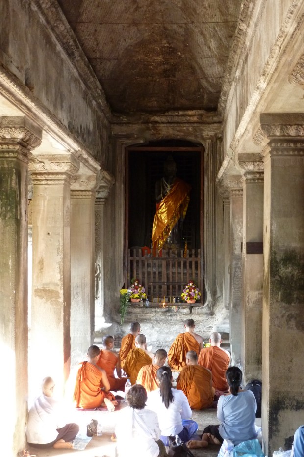
A worship service at Angkor Wat.

Its large moat, enclosures and towers represent the Hindu universe. One could spend days exploring all the carvings and symbolism of this magnificent temple.

angkor-wat67

A view from the southeast corner of the Angkor Wat temple – almost no one goes out here.

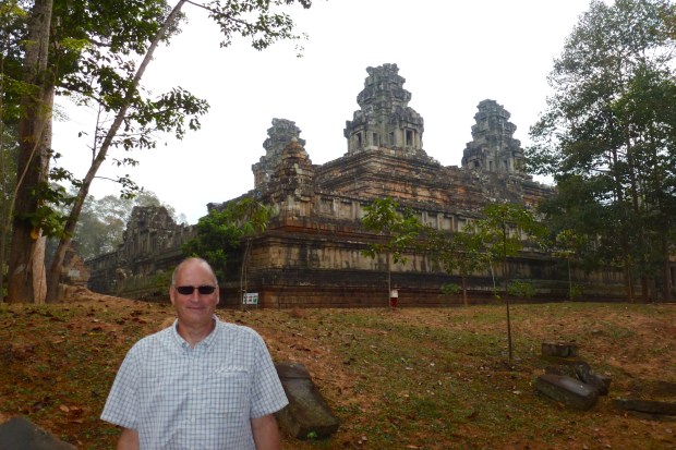
Phnom Bakheng. The last temple we visited on our first day is pretty close to Angkor Wat, and required a 20 minute hike up the hill on which it is located. The temple itself is difficult to get a picture of, due to its orientation on the hill–it’s hard to step back and get a good view, and we found it a bit less impressive than the others.

phnom-bakheng-2

Phnom Bakheng temple.

phnom-bakheng-7

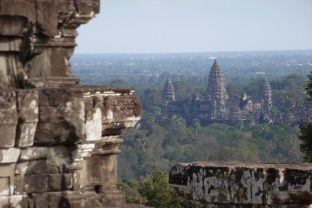
A view of Angkor Wat from the Phnom Bakheng temple.

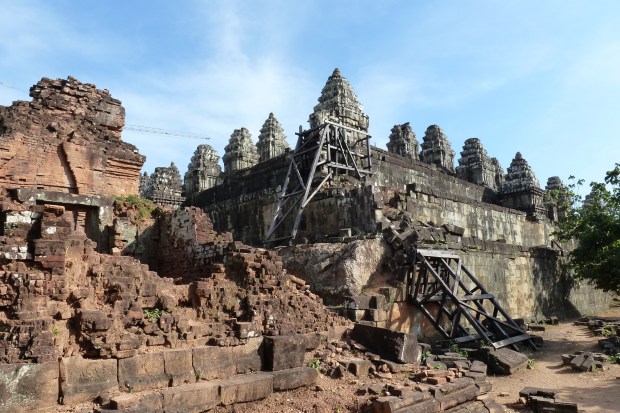
The main reason for climbing the hill (and then climbing up the temple) is for the views overlooking the whole Angkor area and especially Angkor Wat. Many people (like us) make the hike up in the afternoon or right before sunset for the views. This temple is the oldest at Angkor, dating from the late 9th century and was the first state temple as Angkor became the capital city of the Khmer Empire. This temple is also undergoing restoration work.

More to come in my next post!


A Visit to Siem Reap, Cambodia – Overview

There aren’t a lot of words that can really describe the feeling of being at the world renown Angkor temple complex near Siem Reap. For me, being at Angkor Wat (featured image above) and the surrounding temples was the equivalent of seeing the pyramids of Egypt for the first time—I guess “awestruck” would be the best word I can come up with.

ta-som-14

The entrance to Ta Som temple, one of the most picturesque in Angkor.

These temples and the surrounding landscape are stunning in every sense of the word, the jungle growth surrounding (and covering) them just adds to their allure. In addition to the temples, there are reservoirs, canals and other interesting features of what was an incredible capital city. Angkor was the capital of the Khmer Empire (which covered parts of modern Cambodia, Thailand, Laos and Vietnam) for about 500 years, from the 9th century to the 12th century. Considering how magnificent the ruins are today, one can only imagine how palatial the city must have been almost a thousand years ago.

We arrived in Siem Reap in late afternoon after a 7-hour bus ride from Phnom Penh. The bus dropped us off at a central point and then the bus company provided taxis to take us to our various hotels. Siem Reap was larger than I expected, for some reason I was thinking it might be a fairly small town on the outskirts of the Angkor temple complex for which it is known. There is a fairly small central core old town where most of the tourists and related services are located.

banteay-kdei33

One of our meals in Siem Reap – with crocodile and other meats and fish (crocodile tasted like a fishy pork).

beng-melea1

You can get yourself a “happiness pizza” in some towns in Cambodia – a pizza that has a little marijuana in it!

Speaking of tourists, Siem Reap is definitely a major tourist hub with a modern small airport, and the town seemed overrun (at night) with tourists compared with Phnom Penh. We visited during the height of tourist season, since the weather is at its best in January.

siem-reap0

One of the main streets (Pub Street) at night in Siem Reap.

Even with all the tourists, we were able to see everything we had planned on during our 2 ½ days. It would be easy to spend a week here, since there are numerous temple ruins all over the region, not just in Siem Reap. My son and I visited one distant temple ruin (Beng Melea) which was about 60 km from Siem Reap on our 3rd day (we hired a taxi), while my wife and daughter visited a local museum and did some shopping.

beng-melea40

The ruins of Beng Melea temple – fewer visitors here and we were able to wander around uninhibited.

Admittedly, some people might get “temple fatigue” after a day or two, but that wasn’t a problem for us!

The ticket entrance to the Angkor temple complex is about 4 km (2.5 miles) north of the city, and the temples are located another couple kilometers beyond the entrance.

angkor-thom-south-gate9

The busy South Gate entrance into the Angkor Thom Temple complex, which is 1.5km north of Angkor Wat (the signature temple of Angkor Archeological Park, and the featured image of this post).

There are numerous transportation options, including joining a tour, getting a taxi, renting bicycles, mopeds, or doing as we did and hiring a tuk tuk that had room for 4 people. Since the terrain in this part of Cambodia is very flat, getting around on a bicycle or moped would not be difficult; however, the distances from the town to the temples and from temple to temple are significant enough that I would rather enjoy time at the sites.

Our tuk tuk (in our case a motorcycle pulling a cart) was $20 for the whole day.

banteay-kdei32

Our tuk tuk. The driver put up a hammock to rest while we toured.

We just pointed out on the map the temples we wanted to visit that day and our driver took us on a route to cover those temples. This was a great way to go, we could visit the temples on our own terms rather than having to be with a larger tour.

Practical Considerations:

Our hotel was within walking distance of the old part of the city where many restaurants, shopping bazaars and nightlife keep tourists occupied in the evenings. There is even a Hard Rock Café in town. Lots of variety of food is available, and many small tourist agencies which can arrange transportation or day trips to nearby locations also. Hotel accommodations vary from grand, large hotels to small boutiques.

The Angkor temple complex is huge, and we spent two days exploring it. We typically started at 8 am. The temples are open very early, but we found late afternoon also worked well for avoiding the peak crowds that come in around 10 am and leave around 2 pm. If you have just one day you can realistically visit 6 or 7 temples, and get a pretty good feel, but you probably won’t get to experience the quieter temples that are further off the beaten path (we visited 17 temples in 2 ½ days!). A pass for the Angkor temple complex is $40 USD for 3 days in a 7-day period, and most temples will require you to show your pass, so don’t lose it! There are lots of small vendors around the main temples to buy water and snacks.

In my next couple of posts, I will share more about the temples we visited each day.


A Day in Phnom Penh: A Bustling City with a Dark Past

From Krabi, Thailand we flew (via Bangkok) to Phnom Penh, Cambodia. Although many tourists head straight to Siem Reap to visit the ancient Angkor temple ruins and completely bypass Phnom Penh, we took an extra day to see this interesting city. I had heard about the horrors of the Khmer Rouge when I was a child and our visit allowed us to learn more about what had happened. More below on this.

As we talked with our taxi driver from the airport to the hotel, we ended up arranging with him to give us a tour of Phnom Penh for $15 per person, which we felt was reasonable to take the four of us around all day.

Our overall impression of Phnom Penh was that it is a little less wealthy than Bangkok and definitely less clean.

phnom-penh-6

My daughter, son and wife enjoying a typical street scene in Phnom Penh.

Royal Palace

One of the major attractions in Phnom Penh is the Royal Palace, not unlike the Royal Palace in Bangkok, but a little less ostentatious in décor.

phnom-penh-royal-palace-10

Part of the beautifully landscaped Royal Palace.

phnom-penh-royal-palace-19

Another view of the Royal Palace grounds.

phnom-penh-royal-palace-jade-buddha

An emerald Buddha in the Royal Palace.

It was also fun to just wander the streets a bit. We went into a large covered market that had about anything you can imagine.

meat-market

I wonder what kind of animal had the nice long tail, hanging in front of the counter?

phnom-penh-central-market-5

More delights available in the market!

We enjoyed Cambodian cuisine – many curry and seafood dishes, along with other oriental delights.

cambodian-dinner2

One of our meals in Phnom Penh.

We even tried fried tarantula (yuck)! All kinds of insects and other creatures were available for adventurous snacking.

phnom-penh-cockroach-and-spider-dinner-1

A nice street food pile of big spiders and beetles.

wat-phnom-12

The Wat Phnom, a famous temple in Phnom Penh.

wat-phnom-11

Inside the Wat Phnom.

In addition to various temples and the Royal Palace, the other primary sights relate to the tragic period of the Khmer Rouge regime (during which time Cambodia was known as Democratic Kampuchea) which lasted from 1975 to 1979. About 25% of Cambodia’s population perished during this period and many people were kicked out of their homes and relocated to other parts of the country.

The Khmer Rouge targeted anyone who was educated, especially those who might be sympathetic to Western values or beliefs, or anyone who was well-off economically. As a sign of how absurd things became, anyone who wore glasses was thought to be an intellectual and therefore an enemy of the state. So many people with poor eyesight got rid of their glasses. Undoubtedly many of the brightest minds in Cambodia perished during this period. I am old enough to remember hearing about the Khmer Rouge on the news and about the terrible atrocities. It was a bit surreal being here, where so much suffering had taken place.

Tuol Sleng Museum

Tuol Sleng prison, now a museum, was created from what was a high school. It was the most secretive of the country’s 196 prisons.

phnom-penh-toul-sleng-museum-3

Exterior view of the Tuol Sleng Prison, now a museum.

Most of the prisoners taken to this prison were accused of fictitious acts of treason, such as collaborating with foreign governments or spying for the CIA or KGB.

phnom-penh-toul-sleng-museum-21

Photos of some of the unfortunate victims at Tuol Sleng prison.

phnom-penh-toul-sleng-museum-6

An interrogation cell with shackles.

phnom-penh-toul-sleng-museum-12

Prisoner rules.

Typically, the entire family would be imprisoned. Most often, prisoners had no knowledge of the charges against them when arrested, but they were tortured until they confessed to whatever crimes they had been accused of. They were then marked for execution. At least 12,273 prisoners (and possibly many more) passed through this prison and only about 200 survived.

phnom-penh-toul-sleng-museum-30

Cells at Tuol Sleng prison–in an area that used to be classrooms.

phnom-penh-toul-sleng-museum-33

Some of the torture instruments used on the prisoners.

phnom-penh-toul-sleng-museum-1

My son and I with Mr. Chum Mey, a survivor of Tuol Sleng prison.

Eventually, the Khmer Rouge regime was ousted by the Vietnamese in 1979 after about four years of absolute hell. This museum is well done, with explanations posted throughout the site.

Choeung Ek Genocidal Center (Killing Fields)

This outdoor museum is another “must do” in Phnom Penh. It is located 15 kilometers (about 9 miles) south of the heart of the city (the drive out to the site is interesting in itself).

phnom-penh-3

Homes along a waterway (covered in foliage) on our way out to the Killing Fields.

phnom-penh-5

The dusty road out to the Killing Fields museum.

phnom-penh-choeung-ek-killing-fields-2

Entrance to the Choeung Ek Museum or Genocidal Center.

This site is where many of the prisoners of the Khmer Rouge were brought to be slaughtered and buried in open pits.

phnom-penh-choeung-ek-killing-fields-10

In the foreground are the burial pits. The tall structure contains neatly arranged skulls of many of the victims.

phnom-penh-choeung-ek-killing-fields-20

In the tall pagoda-like structure, the victims’ skulls are arranged by how they were murdered – axe, hammers, rods, etc.

There is a marked path with explanation signs and also a good audio guide available to explain what happened here.

phnom-penh-choeung-ek-killing-fields-14

As the sign says, babies were bashed against this tree trunk.

To say the least, it was a very somber experience, but well worth the visit to understand what the Cambodian people have suffered in their fairly recent past.

Even today, as you walk among the burial pits, it is not uncommon to find bits of clothing and bone.

phnom-penh-choeung-ek-killing-fields-12

The sign says “Don’t step on bone”. Bits of clothing of the victims is visible in the lower right.

phnom-penh-choeung-ek-killing-fields-15

A bin stacked with bones from excavations.

We enjoyed our day in Phnom Penh. It was a very worthwhile stop on our journey. From Phnom Penh we went on to Siem Reap, home of the world famous Angkor temples, including Angkor Wat. I will write about these magnificent temples in my next couple of posts.

Note: During our day excursion, our taxi driver stopped by a tourist agency, and we arranged bus transportation for the following day to go to Siem Reap. The cost was $15 per person for a decent bus to take us on the approximately 6-hour drive to Siem Reap. While you can also fly there, it was fun to drive through and see the countryside. Beware: Part of the road to Siem Reap is unpaved and VERY dusty. Our suitcases (in the lower storage area), were coated with fine dust by the end of our journey. You may want to consider wrapping your bag in cellophane before placing it in the storage area!

 Also, although Cambodia has its own currency, the US dollar is widely accepted and many prices are quoted in US dollars, so take plenty of small bills. If you pay in US dollars at a store, you will get Cambodian currency in return. These transactions make many prices more expensive than Thailand, although prices are still relatively cheap by U.S. standards.

Highlights of Thailand, Part 4: Railay Beach – One of the Most Beautiful Places on Earth

I know there are a lot of amazing sights in this world, and I’ve had the privilege of seeing many of them. One place that is now definitely on my list of “most amazing sights” is Railay peninsula, located on the eastern shore of the Andaman Sea, about 80 kilometers straight east of Phuket. Phuket is probably the most well-known resort and beach location in Thailand, but we decided to go to a bit quieter area. My nephew and his wife had visited here about a year earlier, and based on their recommendation we decided to make the Railay beaches home for a few days.

east-railay-beach-environs10

My wife and son upon our arrival at Railay peninsula. Typical long boat transportation to/from the peninsula is right behind them.

What a good choice! The peninsula (with its beautiful beaches) is isolated from the mainland due to rugged terrain and high cliffs and is accessible only by boat.

railay-viewpoint-1

A view overlooking Railay peninsula. West Railay Beach is in the distance and East Railay Beach is in the foreground. (Phra Nang Beach, shown below, is to the left and not visible). This view required a very steep, short hike.

There are several hotels on both West and East Railay beach, and some guest houses hidden up in the hills. We decided to stay in a pretty nice resort on West Railay Beach, and we were glad we did.

railay-sand-and-sea-resort-room

Our bungalow on West Railay Beach.

railay-beach-sand-and-sea-resort-2

Our hotel’s pool, overlooking West Railay Beach.

railay-beach3

There are lots of restaurants near the beaches.

The setting was gorgeous – a wide crescent shaped sandy beach with high cliffs at either end. Walking paths take you across the peninsula and up into the cliffs.

railay-beach2

An early morning view of one end of West Railay Beach.

railay-beach1

An early morning view of the other end of West Railay Beach.

There are lots of things to do here. You can spend your whole time blissfully on the Railay beaches, at your hotel pool, or hiking into the nearby cliffs and caves.

phra-nang-railay-beach-environs-25

A view of Phra Nang Beach, on the southern end of Railay peninsula, from some overhanging cliffs – a surreal spot.

phra-nang-beach82

Sunset at Phra Nang Beach

west-railay-beach-environs17

Near West Railay Beach there is a more rustic spot with backpackers.

Additionally day trips via boat take you to islands around the area. One day tour (on a speed boat) took us to a few other islands and included time for lounging and snorkeling. Hong Island was a favorite stop, with another stunning beach, and the island is a national park.

railay-beach-hong-island-tour-21

The beach on Hong Island. A photo does not do justice to the beauty of this spot.

railay-beach-hong-island-tour-tsunami-damage-19

A remnant on Hong Island of the huge Tsunami that devastated much of the region on December 26th, 2004.

hong-island

A stop for snorkeling on our speed boat day tour.

railay-beach-hong-island-tour-8

Another stop on our speed boat tour, Koh Phak Bia island.

On another day we took a ferry to Phi Phi island. It is a pretty large ferry (foot traffic only), and is slow.

phi-phi-island-1

A beach on Phi Phi island.

Phi Phi Island is a tourist hotspot because it is close to Maya Beach, the famed filming location for the 2000 movie The Beach with Leonardo DiCaprio.

Railay Beach was our last stop in Thailand. On our final morning we took a long boat back to Ao Nammao pier, then a taxi to the Krabi airport (which we had prearranged) and then a flight from Krabi to Bangkok and another flight to Phnom Penh, Cambodia (our next destination).

If you get the opportunity, do NOT miss this part of Thailand.

Getting There:

From Chiang Mai, we took a direct flight to Krabi, the gateway to many beach destinations. From Krabi, we took a taxi to Ao Nammao pier, a tiny port where you then take a long boat with your luggage (about a 15-minute ride) to East Railay Beach. It is then a short walk across the peninsula to West Railay Beach. Alternatively, you can take a taxi from the Krabi airport to Ao Nang, and get a long boat from there to West Railay. Ao Nang is a little busier port.

It is wise to prearrange your taxi back to Krabi airport, which can be done at Ao Nammao pier upon arrival from the aiport. Also note that long boats require a minimum number of passengers to depart from Railay Beach or you will have to pay the equivalent fare of a full boat. Allow yourself plenty of time for the travel logistics to catch your flight.

Highlights of Thailand – Part 3 (Chiang Mai)

One of the primary destinations in Thailand for most tourists is Chiang Mai, and this was no exception for us. This old, culturally rich city is located in the northern part of the country, about 689 km (428 miles) from Bangkok. We definitely noticed that the weather was slightly better than Bangkok—a little cooler and less humidity.

One option for getting to Chiang Mai is an overnight train from Bangkok. We decided to go this route.

Chiang Mai Train (3)

Our train to Chiang Mai. (Bangkok Station)

Having done an overnight train in Egypt from Cairo to Luxor, we knew what to expect and the journey was similar, although this trip might have been a slightly smoother ride. It took about 12 hours (7 pm to 7 am). Upon our arrival at the Chiang Mai train station, we got a taxi to our hotel, left our bags there and then took off exploring on foot.

Chiang Mai Hotel

Our hotel in Chiang Mai. Great location, inside the old city.

There is an abundance of things to do in Chiang Mai, from visiting temples in the old city, to getting into the surrounding mountains for all kinds of adventures. We spent two days here, one day in the town and one day in the surrounding countryside.

The old city (founded in the 1200’s) is laid out in a square with a moat surrounding it. It was the capital of a tributary kingdom to Siam, and hence its many monuments and temples. We arrived on New Year’s Day, but it seemed to be pretty much a normal day around town.

Chiang Mai Wat Chiang Mun (9)

At one of the temples we visited in Chiang Mai, they had a breakfast social going on and offered us a treat (noodles in banana leaves).

Temples were open, restaurants were open, and tour companies were open for business too.

Chiang Mai Wat Phan Tao (2)

Wat Phan Tao temple. This was a very unique temple, made out of wood. We almost felt like we were in Norway with the wood structure.

Chiang Mai Wat Tung Yu (5)

Wat Tung Yu temple.

Chiang Mai Wat Prah Singh (8)

A procession at Wat Phra Singh temple.

Chiang Mai Wat Prah Singh (10)

Donation station in Wat Prah Singh. Buddhist monks are revered in Thailand and receive many donations.

Chiang Mai Ancient Pagoda (3)

Wat Chedi Luang, from the 14th century. Earthquakes from as far back as the 1500’s have taken their toll on this old structure, also known as the Ancient Pagoda.

Chiang Mai Reclining Buddha (2)

A reclining Buddha from the 15th century. It faces the Ancient Pagoda above.

About 30 minutes outside the city is the golden temple of Wat Phra That Doi Suthep, Chiang Mai’s most famous temple. Traffic up to the temple was busy and slow, but we managed to make it just before dusk.

Chiang Mai Doi Suthep (2)

You climb 309 steps up to Wat Phra That Doi Suthep.

Chiang Mai Doi Suthep (18)

Wat Phra That Doi Suthep Temple. This beautiful temple is gilded in gold. The whole complex sits on a hill overlooking Chiang Mai.

Chiang Mai Doi Suthep (20)

Buddha images at Doi Suthep temple.

Chiang Mai Doi Suthep (25)

The lovely ornate terrace overlooking the city of Chiang Mai at Doi Suthep temple.

On our 2nd day, we knew we wanted to get up into the mountains, and there were lots of tour companies who offered various treks. We arranged day trip that did the following: A visit to a butterfly garden, and a visit to a Karen Long Neck tribal village, a hike up to a falls, lunch, an elephant ride (which was personally quite a story), and a raft trip down a river. A lot in one day, but it was a perfect blend of activities.

Chiang Mai Long Neck Karen Tribe (7)

The women who wear these brass rings are from a sub-group of the Karen people, called Padaung. The ancestral home of these people is believed to be Burma, but others believe it to be China. The long neck is considered to be of great beauty and attractive to a potential husband. Many Padaung have migrated to Thailand from Burma to escape the physical and political oppression of that country’s past regimes.

Chiang Mai Adventure Day (12)

My son on the trail to the falls.

Chiang Mai Adventure Day (10)

Another view on our hike. Some backpacker shelters.

Chiang Mai Adventure Day (15)

At the falls – there was a great little pool at the base to cool down and enjoy after the hike.

Chiang Mai Adventure Day 50

I was asked to ride “bareback” on the elephant’s neck. My first experience at doing this – I was just hoping I wouldn’t fall into the river!

From Chiang Mai we flew to Krabi for a beach adventure, I’ll cover this in my next post!

Highlights of Thailand – Part 2 (A Day Trip to Ayutthaya)

On our 2nd day in Bangkok we decided to take a day trip to Ayutthaya Historical Park a UNESCO World Heritage Site. This is an incredible set of ruins, covering a large area. Visiting them was almost an afterthought. How crazy of me. It would be a huge mistake to miss this impressive sight on a visit to Bangkok.

Ayutthaya Wat Chaiwatthanaram (13)

A view in Wat Chaiwatthanaram. (Wat means temple). This is one of the temple groupings in Ayutthaya.

The ancient city of Ayutthaya was the original capital of this region of Thailand, and dates back to 1350 AD. It was razed by the Burmese in the 1700’s, leaving behind a wealth of interesting ruins. Ayutthaya is located 85 km north of modern Bangkok, and can be reached via auto, bus, river boat (on the Chao Phraya river) or train. We chose to take the train from the main (Hua Lamphong) Bangkok train station.

Bangkok Train Station

Hua Lamphong Train Station in Bangkok.

This was a convenient way to go since we were planning to take the overnight train to Chiang Mai that evening, and we just stored our bags at the train station during our day trip.

Bangkok Train Station (2)

We had to laugh at this sign in the baggage storage area at the train station – there are rats!! Luckily our bags were intact when we got back from Ayutthaya.

It was about a 1.5-hour journey to the town of Ayutthaya.

Train to Ayutthaya

Our train to Ayutthaya.

Once you exit the small train station, you then take a little boat across the river to the ancient ruins.

Ayutthaya Train Station

The Ayutthaya Train Station.

Ayutthaya River Crossing

The Chao Phraya River crossing the far side is where the ruins are located.

I highly recommend a visit to Ayutthaya – the old temples, palaces and other structures are massive and interesting to visit. We were able to visit 4 major groupings in about 4 hours.

The ruins are spread out, in groupings scattered over a large area and require some sort of transportation to visit – walking would be impractical from site to site, especially in the heat. All kinds of transportation rentals are available, from bicycles, to tuk tuks (motorized rickshaws), to mopeds. Or, you can arrange a day bus tour from Bangkok. Once we crossed the river, we rented mopeds and had a blast zipping from one site to another.

Ayutthaya Mopeds

Our son and daughter on one of the mopeds.

Ayutthaya Wat Maha That (5)

Wat Maha That. Our first grouping of ruins at Ayutthaya.

Ayutthaya Wat Maha That (6)

A main thoroughfare in Wat Maha That.

Ayutthaya Wat Maha That (9)

Another view of Wat Maha That.

Ayutthaya Wat Chaiwatthanaram (4)

Wat Chaiwatthanaram. The second set of ruins we visited, and perhaps the most impressive. They are located the furthest away from the other ruins.

Ayutthaya Wat Phra Si Samphet (5)

What Phra Si Samphet. Our 3rd set of ruins. It was the holiest temple in Ayutthaya (the temple itself was destroyed). These Stupas (or Chedis, as they are known in Thailand) housed the ashes of kings.

Ayutthaya Wat Phra Si Samphet (14)

Buddhist monks at Wat Phra Si Samphet, enjoying a day of touring.

Ayutthaya Wat Phra Ram (8)

Wat Phra Ram, our final temple ruins in Ayutthaya.

Since our visit fell on December 31st, the ruins were open for free. Otherwise, there is an entrance fee to each location.

Ayutthaya New Year

New Year’s Eve at Ayutthaya – a great way to spend the last day of the year.

Our moped rental company provided us with a map of the major sites and suggested a route to follow. There are signs in English at each location giving a short history and explanation.


Highlights of Thailand – Part 1

We visited Thailand as part of a three week trip through Asia, which also included Cambodia and Vietnam. Although there is so much more that could be visited in Thailand we concentrated on three locations:

  • Bangkok (including a day trip to Ayutthaya)
  • Chiang Mai
  • Railay Beach (across the bay from Phuket, on the Andaman Sea)

All three places were wonderful and are highly recommended. I will do a post on each major location. Thailand is a great country to visit (friendly people, relatively inexpensive, great food and amazing sights) and someplace that we’d love to visit again. In particular, the beaches and islands of the Andaman Sea are beautiful and alone are worth the trip.

Central Bangkok

Since we only had a couple days in this huge city, we decided to spend one day in Bangkok itself and then one day in Ayutthaya, the old capital city (now in ruins), about a two hour train ride north of Bangkok (I’ll do a separate post on this fascinating place).

Since many of the main sights in Bangkok are along the Chao Phraya River, which runs through the center of Bangkok, we took the “hop on, hop off” river boat (known officially as the Chao Phraya Tourist Boat) and got off at several stops going one direction, and then enjoyed the ride all the way back to our starting point.

Bangkok (7)

One of the typical tourist river boats – lots of open air seating.

There is a subway (metro) stop (Saphan Taskin Station) near where you catch the boat, making the transportation connection easy.

Below are a couple of key stops along the river:

Wat Arun (Temple of Dawn)

This is a major Buddhist temple complex, a symbol of Bangkok and one of the tallest temples (76 meters) in the city.

Bangkok Wat Arun17

A view of Wat Arun and the surrounding buildings.

Wat Arun was built in the early 1800’s. It is decorated in thousands of tiny seashells and Chinese porcelain.

Bangkok Wat Arun  (8)

The main edifice of Wat Arun.

Bangkok Wat Arun18

Detail of decorations of Wat Arun.

As the name implies, the views of this temple are best in the morning or evening.

The Grand Palace

Don’t miss the Grand Palace. Because we were visiting right before the New Year holiday, we were told by locals that the Palace was closed, but as we soon learned, this was a scam (they wanted to take us other places) and the Palace was indeed open (note: weekdays only).

Bangkok Royal Palace  (34)

The main residential palace at the Grand Palace complex.

Bangkok Royal Palace  (36)

The Grand Palace grounds contain a large number of interesting structures–some ornamental, others are functional and used for state events.

Bangkok Royal Palace  (52)

Another view of the Grand Palace grounds.

The exterior décor of the palace buildings is quite spectacular and feels a little surreal; it gives one the idea of the wealth of Thai royalty.

Bangkok Royal Palace  (44)

View of the exterior walkway around the Ordination Hall.

Bangkok Royal Palace  (45)

Detail of the exterior decorations of the Ordination Hall.

The most important structure here is the Ordination Hall, which houses the Emerald Buddha.

Bangkok Royal Palace67

The Emerald Buddha (very small and hard to tell, but he sits at the top of the golden altar). I snapped a quick picture.

Note: It’s a good idea to wear long pants and modest shirts the day you visit the Grand Palace, otherwise you will have to stand in a long line and rent a pair of long pants and cover-ups, which is a hassle and takes time. We had to do this, and while the process worked it was a bit of a pain.

Temple of the Golden Mount (Wat Saket)

This was not a stop on the river, but is pretty close to the Grand Palace. We took a tuk tuk (motorized rickshaw) out to the temple, which sits on a small artificial hill, constructed in the early 1800’s. There is a fair held here in November of every year, following a Buddha relic worshipping ceremony.

BangkokTukTuk

My wife and son getting a tuk tuk ride.

Bangkok Golden Mount (7)

The Golden Mount Temple.

Bangkok Golden Mount (6)

Lifelike miniture images of Buddhist monks at the Golden Mount with offering bowls below each.

Since Bangkok is flat, it doesn’t take much elevation to get a good view of the city. The temple itself was not all that exciting, but the walk up the hill was enjoyable as were the views from the top.

Bangkok

A panoramic view of Bangkok from the Golden Mount.

Lucky Buddha

We made a quick stop here, with the local folks showing us how to make a proper offering at this Buddhist temple. It’s more or less a scam, but was still fun.

Bangkok Luck Buddha Offerings3

My son making offerings at the Lucky Buddha.

Bangkok Lucky Buddha (1)

Another view at the Lucky Buddha temple.

Asiatique Pier

This a major hot spot for restaurants, shops and fish pedicure services. Nice setting on the river.

Bangkok (8)

A Bangkok evening hot spot along the Chao Phraya River.

Bangkok (10)

My daughter getting a fish pedicure at the Asiatique pier.

Just taking the boat ride along the river is entertaining as well. Here are a few views along the river…

Bangkok Chaophraya River (13)

A view along the Chao Phraya river – a mix of the old and new.

Bangkok Chaophraya River (2)

A typical scene along the Chao Phraya River.

Bangkok Chaophraya River (10)

A view of the Bangkok skyline from the Chao Phraya river.

A Few Days on the French Riviera

Following our visit to Corsica, we spent a few days on the Cote D’ Azur, or as it is also known, the French Riviera. This is a beautiful part of France, with little villages clinging to steep hillsides overlooking the blue Mediterranean. It’s easy to see why this area has been a mecca for tourists and the famous and wealthy for decades. As I’ve stated before, France is a favorite country of mine, and this part of France just reinforces my view.

Nice. Nice is the 5th largest city in France, with a wonderful setting on the Mediterranean coast. Nice was founded by the Greeks and colonized by the Romans. They picked a great spot. Nice has a long seafront promenade (Promenade des Anglais) filled with joggers, young couples and folks out for a stroll.

Nice (4)

The Promenade des Aglais in Nice. The beach consists of more pebbles than sand, but was very clean.

The promenade is lined with large hotels, shops, restaurants and extends for several kilometers.

Nice’s Old Quarter (called Vieux Nice) is on the eastern end of the promenade, next to a promontory point (Colline du Château) which can be climbed via 300 or so stairs for great views of Nice and the surrounding coastline.

Nice (10)

A view of Nice from Colline du Château.

Old City Nice (14)

Nice’s Old Quarter.

The Old Quarter has narrow quaint streets, good restaurants and wonderful shops filled with art-worthy sweets and gelato!

Nice France (3)

Even though these look like the real thing, they are just incredibly artistic sweets.

Evidence of the Roman era is still visible, including the ruins of an arena, basilica and a village. The ruins are about a 30-45 minute walk from the Old Quarter.

Roman Baths Nice (3)

The Roman ruins in Nice.

Going east from Nice, here are a few sights:

Villefranche-sur-Mer. Just east of Nice is the village of Villefranche-sur-Mer, located on a protected bay. Like many coastal towns in Corsica, Villefranche-sur-Mer has an old 16th century citadelle (Citadelle St-Elme) that now houses the town hall and two art galleries. This is a very quiet, scenic (and clearly well-to-do) spot right between Nice and Monaco.

Villefranche sur Mer France (6)

A view of Villefranche-sur-Mer.

Eze. I had heard from several people that we needed to visit Eze. Eze is just east of Villefranche-sur-Mer, and is practically on the border with Monaco.

Eze France (13)

A view of Eze and the coast from the gardens right above the village, where a castle once stood.

Eze is a gorgeous 14th century fortified hilltop village overlooking the Cote D’Azur. It is postcard perfect.

Eze France (10)

One of the alleyways in Eze.

Eze France (11)

Another perfect spot in Eze.

The only thing that “bothered” me is that it is completely a tourist town with numerous boutiques and shops and of course lots of tourists. However, we loved the setting and views.

Monaco. The Principality of Monaco is next door to Eze and is one of the tiniest countries in the world (as well as the world’s oldest monarchy). Monaco is a tax haven and its wealth is evidenced by the number of Lamborghinis and Ferraris racing down the winding streets.

Monaco (27)

Monaco’s harbor and surrounding area, as seen from the hilltop fortress area where the royal palace is located.

Monaco (22)

Street scene in Monaco.

Monaco Casino (19)

The world famous Monte Carlo Casino in Monaco. Only for serious gamblers!

Monaco Cathedral (35)

Monaco’s cathedral, where Princess Grace and Prince Rainier III were married in 1956.

Given how small the country is, we quickly found a car park after crossing the border and explored the country on foot, walking up and down the steep hills and winding our way through a maze of apartment buildings built practically on top of each other—it reminded me just a bit of Hong Kong.

Going west from Nice, here are several other sights:

Cannes. Known for its famous International Film Festival, we thought we’d check out Cannes. This area suffered major flooding damage just a year ago, and although there were still some signs of the flooding (piles of damaged goods in a few places) for the most part you wouldn’t know this area had been touched. The Old Town with an 11th century clock tower and the 16th century church called Notre-Dame de l’Espérance sit on a hill overlooking the harbor filled with huge yachts and the more modern part of the city and famous beachfront.

Cannes (8)

The old clock tower in Cannes, right next to the 16th century church.

Cannes (9)

A view of Cannes and harbor.

Cannes (1)

The InterContinental Carlton luxury hotel in Cannes, built in 1911.

St-Paul-de-Vence. This is a walled hilltop village not far from Cannes. It is a magnet for artists, with numerous art galleries and studios. It is a beautiful sight sitting perched on a hilltop not far from the coast.

St. Paul de Vence (1)

A view of St-Paul-de-Vence.

St. Paul de Vence (3)

The gated entrance into St-Paul-de-Vence.

St. Paul de Vence (11)

The 13th-14th century Keep (Donjon) in St-Paul-de-Vence. Used as a prison years ago.

Vence. This town is probably the poor sister of St-Paul-de-Vence and Eze. It was the most authentic town of the three, feeling more like a typical French village. The historic center’s layout is based on a Roman design-encircled by an oval wall. There are lovely old churches and little squares tucked away in spots throughout the town.

Vence (3)

One of the small squares in Vence.

Vence (4)

Street scene in Vence.

When traveling through this area, be aware that the roads are narrow, with sharp curves and speedy drivers. Traffic is fairly heavy, especially going west from Nice. Even though distances are not far, it will take a bit longer to get to these locations than you might expect.


The Isle of Corsica – One of the Hidden Gems of France – Part 3 of 3

From Bonifacio (for information on Bonifacio, click here, for a map of Corsica click here) we spent our last few days working our way north along the east coast to Aléria and then on to Corte in the interior, then Calvi (on the northwest coast) and finally Bastia (also on the east coast), our final stop in Corsica. On the east side of the island there is a little more flat terrain near the coast and therefore the roads are faster.

Aléria. The little town of Aléria has an old church and castle-like building that holds a museum and ticket office for the nearby Roman village ruins.

Aleria Corsica (2)

An old little stone church in Aléria, near the Roman ruins.

Aleria Corsica (1)

The Roman ruins museum in Aléria.

There were a number of ancient settlements around this area, but it was the Romans who built the harbor port city known as Aléria starting in 80 BC, which was inhabited throughout the duration of the Roman Empire. The ruins are not extensive, mainly foundations and a few baths remaining.

Aleria Corsica (7)

A view of part of the Roman ruins of Aléria.

Given the proximity to Italy, one would think the Romans would have colonized Corsica more. But then, like now, with its rugged topography, Corsica was more of a hinterland and was never completely conquered and brought under the domination of Rome

Old Bridge and Church Corsica (2)

There are a number of old Genoese (14th-15th century) bridges in Corsica, this one is near the road on the way to Corte from Aléria.

Corte. I expected Corte to be a little village, and I was surprised to see that it was a good sized town. Corte was the capital of Corsica during its period of independence in the mid 18th century.

Corte Corsica (9)

A view of the old town of Corte, with the fortress sitting at the top.

In the main square, there is a statue of Pascal Paoli (1725-1807) the founding father of Corsica.

Corte Corsica (3)

The main square in old Corte with the statue of Pascal Paoli to the right.

Even 250 years later, there are bullet holes still visible in the buildings surrounding Place Gaffori, marking the fight over independence that took place here.

Corte Corsica (11)

Place Gaffori in old town Corte. Note the bullet holes in the building.

The old town slopes up a hill located in the middle of a deep valley. The Citadelle and 15th century fortress sit atop the old town, commanding a good view of the surrounding valleys. The old town below the Citadelle has several small squares, churches with narrow alleys, and restaurants. Although not visible from the main town, the fortress has a very modern, large museum and conference center located next to it. Corte is home to the aptly named Corsica Pasquale Paoli University, where students speak Corsican.

Corte Corsica (34)

Looking down on the old town of Corte from the fortress.

Corte Corsica (25)

The old 15th century fortress in Corte, photo taken from the Belvedere, a scenic view spot.

There are also a few old hilltop towns in the great vicinity of Corte, located off very narrow steep and winding roads up in the hills.

Calvi. From Corte, we traveled north and west over to Calvi, another extremely picturesque town situated on a beautiful bay surrounded by mountains.

Calvi Corsica (2)

A view of the beautiful town of Calvi with its magnificent bay and Citadelle.

Calvi is a jet-setting hotspot in the summer with numerous sailboats and yachts filling its docks and harbor. The huge Genoese Citadelle at the entrance to the bay really dominates the whole area.

Calvi Corsica (4)

A closer view of Calvi and the Citadelle.

There is a nice beach here too, overlooking the harbor and town. The Citadelle was pretty quiet, at least during the time of year we were there (October).

Calvi Corsica (23)

The entrance to Calvi’s Citadelle.

We enjoyed sitting by the harbor and having our lunch.

Calvi Corsica (10)

Calvi’s harbor, lined with outdoor cafes.

Calvi Corsica (24)

There is some evidence that the explorer, Christopher Columbus, was born in Calvi. Hence the name of this souvenir shop.

Lumio Corsica (4)

We stayed in the picturesque small town of Lumio, just across the bay from Calvi.

Bastia. From Calvi, we crossed back over to the north east coast and made our last stop in Corsica. We were really surprised at how large Bastia was. It is a major city and the commercial hub of Corsica. Like many coastal Corsican towns, Bastia has a large Citadelle overlooking the harbor (Vieux Port) and a scenic and large old town area.

Bastia Corsica (21)

The harbor of Bastia. The twin towers of the 16th century church of St. Jean Baptiste are a local landmark.

Bastia felt similar to many large European towns with multiple squares, shopping streets, great churches and restaurants lining the harbor and squares.

Bastia Corsica (1)

A major shopping thoroughfare in Bastia.

Bastia Corsica (13)

Interior of the Oratory of the Confraternity of the Holy Cross. This church contains the Holy Crucifix of Miracles, discovered drifting on the sea by two fishermen in 1428.

Bastia’s Citadelle streets were fairly quiet, and the area had a non-touristy feel. There are good signs pointing out historically significant buildings in this area.

Bastia Corsica (29)

The Louis XVI gateway into Bastia’s Citadelle.

Bastia Corsica (26)

A street scene in Bastia’s Citadelle.


Bastia Corsica (20)

An old building in the Citadelle. I’d hate to have to work on or rebuild these walls!

Bastia has decent sized airport, so it was easy to fly back to Nice from here, which kept us from having to backtrack across the island to Ajaccio. This third post concludes our tour of Corsica. We highly recommend visiting this wonderful island!

The Isle of Corsica – One of the Hidden Gems of France – Part 2 of 3

From Ajaccio we worked our way south along the west coast towards Bonifacio, which is located at the southern end of Corsica. Two interesting locations on the way to Bonifacio are Filitosa and Sartène.

Filitosa

Filitosa is one of several prehistoric sites on Corsica and probably the most well known, having earned UNESCO World Heritage status. This site is privately owned. It is located about 65 km (40 miles) from Ajaccio. Although not far, it takes about 90 minutes to get here on the roads that follow every curve of the hilly country. This site dates back as far as the early Neolithic era (6000 BC), and covers a pretty large area. Surprisingly, the ancient artifacts here were not discovered until 1946.

Filitosa Corsica (3)

One of the earliest dwellings at Filitosa.

Filitosa Corsica (2)

One of the most detailed and best preserved menhirs at Filitosa. There are also carvings on the back, representing the physical back of a human.

Filitosa Corsica (14)

A field of menhirs in Filitosa.

There are upright carved stones in human form (called menhirs), temple structures, a quarry, some fortifications and foundations of Bronze Age huts.

Filitosa Corsica (4)

A lookout platform at Filitosa.

Filitosa Corsica (11)

A chamber in what is called the Western Monument.

Filitosa Corsica (6)

This place is called the Central Monument at Filitosa. It has a commanding view of the countryside.

Filitosa Corsica (21)

The enchanting hill where the monuments are found. It has a feel like it could be a location right out of “The Lord of the Rings”.

We found Filitosa quite interesting. Allow a couple hours for a visit. We got there first thing in the morning and had the site largely to ourselves. You can obtain a guidebook at the site and there is a small museum as well.

Propriano Corsica (3)

The town of Propriano, just south of Filitosa. It has a beautiful harbor surrounded by mountains. We stopped here between our visits to Filitosa and Sartène.

Sartène

This town is known as “the most Corsican of Corsican towns” and is in a picturesque hillside location. It also has an attractive old town center. The type of stone used here for construction gives the buildings a very austere appearance.

Sartene Corsica (13)

View of the exterior fortifications of Sartène.

Sartene Corsica (10)

Street scene in Sartène.

Sartene Corsica (12)

Old doorways in the center of Sartène.

We enjoyed wandering through the streets and admiring the old buildings.

Bonifacio

Bonifacio Corsica (26)

If driving in to Bonifacio, this is your first stunning view. The “Stronghold of the Standard” bastion was used until the 18th century by the Genoese to defend Bonifacio.

If I had to pick just one favorite place in Corsica, Bonifacio would be it. The unique sight of a massive fortress and medieval town jutting straight up from the little bay on a narrow strip of land is striking. The Republic of Genoa took control of Bonifacio in 1195 and the whole of Corsica in 1294 after defeating the Pisans. Bonifacio became an autonomous city of the Genoese republic in 1388 and even issued its own coinage.

Bonifacio Corsica (107)

The steep walk up to the old medieval fortifications from the harbor.

Bonifacio Corsica (29)

A view of the old medieval town of Bonifacio from a cliff walking path.

Bonifacio Corsica (6)

The last part of the ascent into the bastion of Bonifacio.

No wonder this town withstood numerous sieges, and was considered such a strategic spot. One siege by the King of Aragon (a region of modern Spain) lasted for 3 months. In the end, the King, even with his mighty fleet, could not take Bonifacio and he left in defeat in early 1421.

Bonifacio Corsica (130)

Looking down on Bonifacio’s harbor from the bastion.

Bonifacio Corsica (102)

Another view of the walls surrounding Bonifacio. You can walk along most sections of the walls.

We spent two days here and you could easily spend more. This is perhaps the most popular spot on Corsica, and it does receive cruise ship visitors. There are a number of beaches in the vicinity and good coastal walks too.

Bonifacio Corsica (53)

The steep Escalier du Roy D’Aragon (King of Aragon’s Stairway) can be appreciated from a boat excursion. This stairway accessed a water supply in medieval times.

Bonifacio Corsica (114)

Climbing the 187 steps of the Escalier du Roy D’Aragon. Doing this a few times a day will get you in great shape!

Bonifacio Corsica (117)

The walk along a pathway below Bonifacio, accessed by the Escalier du Roy D’Aragon.

We took a boat excursion (highly recommended) for a view of the cliffs and old village which somehow clings to the top of the cliffs–you have to wonder when the whole town might fall into the sea.

Bonifacio Corsica (66)

A view of Bonifacio from our boat tour. The houses are literally at the edge of the cliffs.

Boats will also take you to nearby islands which have good beaches. Since we were just past the swimming season, we opted for the coastal tour with a glass bottomed boat, and as part of the tour we were able to go into a small secluded grotto and a beautiful small bay-very cool.

Bonifacio Corsica (96)

Inside the grotto on our boat excursion.

In my last post, we’ll cover the Roman ruins of Aleria, the interior village of Corte, Calvi and the north eastern city of Bastia.