The Isle of Corsica – One of the Hidden Gems of France – Part 1 of 3

When we mentioned to friends that we were going to Corsica, the typical response was “where is Corsica?” Even though it’s part of France, relatively few people in the U.S know much about this island. For the record, Corsica is just north of Sardinia (another great island, which belongs to Italy) and is closer to Italy than it is to France.

Screen Shot 2016-03-20 at 4.17.36 PM

A map of Corsica. We started in Ajaccio on the west coast and ended in Bastia on the northeast coast.

Corsica is a relatively remote part of France and Europe—it’s rugged, mountainous, and sparsely populated, especially in the interior. Corsica has had a tumultuous history, with several nations (such as Spain and France) and medieval city states (such as Pisa and Genoa) staking their claim here over the centuries. Even today, the island is a very independent part of France, and there have been separatist struggles over the years. As a tourist, there is very little evidence of this, except for some banners or signage in the interior villages of the island.

Ajaccio Corsica (4)

A burned out car near Ajaccio – evidence of the Corsican mob? Hard to say.

As a sign of its independent roots, Corsica has its own language (more similar to Italian, although everyone speaks French also), and road signs are in French and Corsican.

Bonifacio Corsica (106)

An example of the excellent food found in Corsica – with heavy Italian influence.

Corsica offers the tourist a large variety of things to do: hiking, climbing, four wheeling, mountain scenery, kayaking, beautiful beaches, prehistoric sites and some very cool old fortified towns with huge bastions. We visited in October, and while the island was quieter, the weather was still good. During the summer, the towns on the coast are a magnet for sailboats and yachts from all over Europe.

We spent about a week on Corsica, starting our visit in Ajaccio and then taking a clockwise one-way route through the island. We rented a car and although distances aren’t far, the roads are winding and fairly slow. Luckily the local drivers were pretty patient with us as tourists, but I pulled over to let them pass every chance I got.

Ajaccio. We flew in to Ajaccio from Nice. It was a good place to start our trip. Ajaccio is the capital of Corsica and the birthplace of Napoleon Bonaparte. It has a quaint old quarter, situated on a bay on the west coast of the island.

Ajaccio Corsica (15)

A view of Ajaccio’s harbor.

Napoleon, the early 19th century emperor of France, looms large over Ajaccio, his image can be found in several spots in Ajaccio.

Napoleon Statue Ajaccio Corsica (26)

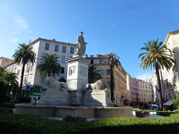
Statue of Napoleon in the form of a Roman emperor in old town Ajaccio.

One of the main sights in Ajaccio is Napoleon’s home and the church where he was baptized.

Bonaparte House Ajaccio Corsica (14)

The street in Ajaccio where Napoleon was born. His house is the building with the green shutters behind his caricature.

Ajaccio Cathedral Corsica (20)

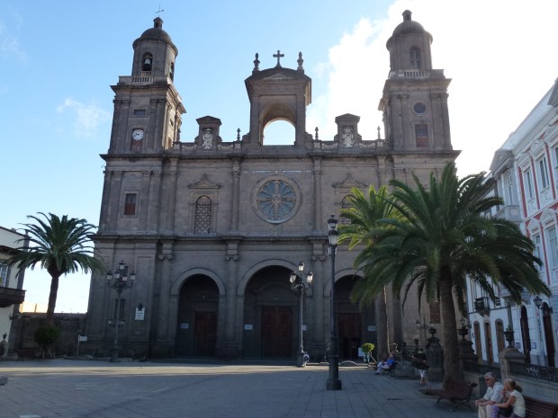
The orange hued Ajaccio Cathedral, where Napoleon was baptized.

Like many costal Corsican towns, Ajaccio has a 15th century fortress guarding the entrance to the protected bay. The fortress is still used by the military and therefore is off limits to tourists.

Ajaccio Corsica (19)

Ajaccio’s Citadelle or fortress, built originally by the Genoese, housed resistance fighters during World War II.

Coastal and Mountain Scenery. We took a day trip north of Ajaccio through the mountains and along the coast. It is a stunningly beautiful island, and even in October I was impressed how green the island is. We had just one day of rain during our visit.

Ota Corsica (2)

The village of Ota, near the Spilonca Gorge, a mountain park and hiking area.

There are little villages nestled high on the steep hillsides. The backcountry has some great trails and rushing rivers. The coastline of Corsica is a mix of rugged terrain and secluded beaches.

Corsica (11)

The beautiful coastline on the southwestern side of Corsica. In the distance is the island of Sardinia.

Towers. There are 15th and 16th century towers dotted all along the coast, 91 of them in total, which were watch towers on the lookout for pirates and also light houses for the Genoese sailors.

Tour de la Parata Ajaccio Corsica (7)

This tower, called Tour de la Parata is close to Ajaccio.

Porto Corsica (3)

A view of the small town of Porto, north of Ajaccio, with its 15th century tower (left side of image).

Corsica

Another tower along the west coast of Corsica.

Many of the towers are not accessible, but a few are. They give the coastline a unique feel, standing as they have for centuries against the wind and the waves.

Pisan Churches. Also throughout the island are tiny churches from the medieval era, many built by the Pisans in the 12th and 13th centuries. Each is unique, but the style is generally familiar to what one finds in northern Italy.

Bastia Corsica (52)

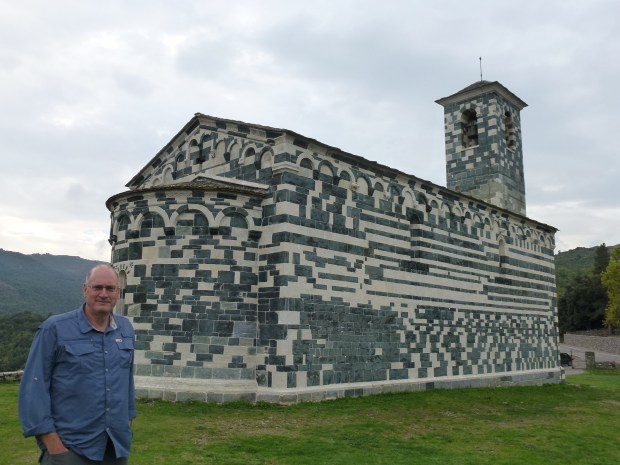
The little 13th century Saint Michel de Murato church near Bastia.

Bastia Corsica (54)

A close-up of one of the carvings on the exterior of Saint Michele de Murato.

Eglise de la Trinite et de San Giovanni Aregno Corsica (5)

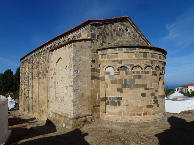
This 12th century church, Eglise de la Trinite et de San Giovanni, is near Aregno, Corsica.

Bastia Corsica (4)

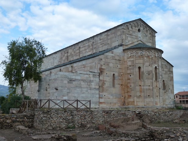
La Canonica. This little church was built by the Pisans in 1119 on the site of a 4th century basilica. It sits next to some Roman ruins, near Bastia.

In parts 2 and 3 of my posts on Corsica, I will review other sights and towns as we traveled south and east around the island.

The Canary Islands – Part 2 of 2 (Tenerife)

Let’s just call it what it is…Tenerife is beautiful and it’s easy to see why it’s the most visited spot in the Canary Islands, and one of the top destinations in Spain and Europe, for that matter. Tenerife is the largest (and most populated) of the Canary Islands, and the north/west and south coasts are especially beautiful. It’s only a short (20 minute) plane ride away from Gran Canaria. The 12,198 ft volcanic peak of El Teide dominates the island and is the highest point in Spain. Probably the second most popular sight is Los Gigantes, a stunning set of high cliffs jutting out of the ocean on the very southwest coast.

Puerto de la Cruz

This is a primary tourist hub on Tenerife and it’s where we stayed. Its location at the midpoint of the island on the northwest shore provides a good base for exploring the island and is quite a beautiful setting – with the waves crashing over the jagged volcanic rocks along on the shore.

Puerto de la Cruz (3)

The rugged and beautiful coastline of Puerto de la Cruz.

Puerto de la Cruz

An evening scene in Puerto de la Cruz – lots of diners fill the streets in the evenings.

Puerto de la Cruz (2)

A church in the main square of Puerto de la Cruz.

El Teide National Park

The soaring volcano mountain of El Teide is a national park and contains a lot of rugged terrain. Going from sea level to 12,000 feet in elevation within just a few miles (as the crow flies) means you are ascending at a very steep rate and negotiating a lot of switch backs.

El Teide National Park (2)

A volcanic outflow “flower” in the park.

The roads on Tenerife and ascending into El Teide National Park are narrow, steep and winding. Once you get into the park, there is a nice visitor’s center with good maps and signage.

El Teide National Park (35)

A view of the peak in the distance.

There is a (expensive) tram that takes you within 600 feet of the summit, but to climb the last 600 feet you have to plan ahead and make a reservation.

El Teide National Park (15)

The tram going up to the top of El Teide.

El Teide National Park (18)

Near the peak of El Teide, where the tram ends.

Otherwise, you can hike around the peak just below the summit for the views and scamper through the jagged volcanic rock, which looks other worldly. Unfortunately, on the day we had allowed for our visit to the park and peak the lower elevations were socked in with clouds for a period of time, but we were still able to get a few views.

El Teide National Park (9)

The moon-like landscape of El Teide National Park.

Los Gigantes

This is the postcard view of Tenerife. In fact, it was a post card I saw in a friend’s office that put Tenerife on my “must see” list. At the port, you can arrange a boat trip (of varying lengths of time) that will take you for a tour, including whale and dolphin watching, depending on the time of year.

Los Gigantes (6)

A view of the port of Los Gigantes with the cliffs in the background.

Los Gigantes Dolphin (2)

A dolphin comes near our boat.

Your boat tour will also stop at the beach for a short time, or you can arrange to disembark at the beach and take another boat back, which is what we did. While we were on the beach, a huge boulder came crashing down off the cliffs which could have easily killed someone. Luckily, it fell and rolled (at great speed) right between some very scared tourists who were running in every direction. It happened so quickly I could not get any video footage.

Tenerife Los Gigantes Masca Beach (2)

The black sand beach among the cliffs of Los Gigantes.

The best access to Los Gigantes is by taking a boat tour out of the nearby port town of the same name. You can also hike down from the town of Masca (discussed below).They aren’t joking when they say on the hike down from Masca and at the beach to be extremely careful of loose rock.

Tenerife Los Gigantes Masca Beach (4)

Enjoying a swim at Los Gigantes.

Masca

The main reason people come to the little village of Masca (in addition to seeing the beautiful setting), is as a starting point for hiking down through steep ravines to the cliffs and beach of Los Gigantes.

Masca (6)

The winding road going into Masca. On most of Tenerife you are either going up or down!

It’s about a 3-hour hike, and once you reach bottom you can catch a pre-arranged boat back to the port. Most people take a taxi to Masca to begin their hike, since it’s a one-way route (unless you’d like to spend a few more hours ascending straight back up the gorge).

Tenerife Los Gigantes Masca Canyon

Looking up into the narrow gorge of Los Gigantes. Hiking up through this gorge leads to the little village of Masca.

A couple other great beach areas are shown below.

Los Cristianos

Near the southern most tip of Tenerife is Los Cristianos, another scenic beach spot and viewpoint, with the island of La Gomera in the distance. Ferries to other islands depart from here.

Los Cristianos

The beach at Los Cristianos.

Playa Americas

This resort area (near Los Cristianos) is a major tourist hub for southern Tenerife with a great beach and numerous hotels and restaurants. If you’re after nightlife, this is where you’ll find it.

Playa de Las Americas (5)

The beach at Playa Americas.

Playa de Las Americas (8)

There’s even a Hard Rock Cafe in Playa Americas.

Small Quaint Towns

Just like on Gran Canaria, there are some quaint small towns in the interior that are worth a little time exploring.

La Orotava

La Orotava (21)

La Orotava is known for its sand murals – in particular this square – see below.

La Orotava

The square in La Orotava is transformed by sand murals – I wish we could have seen this incredible artwork – I had to settle for a picture of a picture! I wonder how they deal with wind?

La Orotava (16)

A display showing how the sand murals are created.

La Laguna

La Laguna (11)

The town of La Laguna is near the airport at the northern end of Tenerife. It was the headquarters of the Spanish Army in the 1600’s. It has a very quaint old quarter.

Vilafora

Vilaflora Iglesia de San Pedro Apostol (5)

The Iglesia de San Pedro Apostol in Vilaflora, a hermitage from the 1500’s.


Vilaflora (2)

The beautiful golden altar in the Iglesia de San Pedro Apostol.

If you have to pick just one island to visit in the Canaries, make it Tenerife. You will find a little bit of everything here – stunning scenery, beaches, mountains, pretty villages, good restaurants and nightlife. Five million tourists a year can’t be wrong!

The Canary Islands – Part I

Overview

If you want to visit a part of Europe that most Americans aren’t familiar with, consider the Canary Islands, an archipelago of 7 islands belonging to Spain located off the west coast of Africa. We wisely decided to visit the Canary Islands following our two weeks in nearby Morocco. We visited two islands (Gran Canaria and Tenerife), which are two of the largest and most developed islands. There are direct flights from Casablanca to the Canaries.

Firgas (1)

A map of the Canary Islands. We visited Gran Canaria (the circular island in the lower center) and Tenerife, to the northwest of Gran Canaria.

Even though these two islands house most of the local population, you can find remote and quiet areas very quickly. We really enjoyed this part of our trip. The difference between Morocco and the Canaries was a bit of a culture shock (the pace of traffic, roads, lifestyle, etc.), and we felt we were stepping from one world to another after our 1.5 hour flight.

Gran Canary Scenery (5)

The landscape of Gran Canaria, near the caldera of the volcano that was the island’s origin. The elevation here is about 6,000 feet.

For a combination of rugged volcanic mountains, loads of hiking trails, beautiful beaches and small quaint European towns, the Canary Islands are hard to beat.

Gran Canaria Hiking Sign

A sign showing hiking trails in the mountains of Gran Canaria.

The Canaries are only about 100 miles (depending on the island) off the coast of Western Sahara, a region of Africa administered by Morocco. While Spanish is the primary language, the high number of tourists (and residents) from the UK make English more common than in mainland Spain. Even though these islands are close to the Sahara Desert, they have a mild climate and pleasant temperature all year long. The climate zones vary greatly within each island and from island to island due to changes in elevation and the prevailing winds. Some areas are a bit desert-like, other areas are forested and green, and you’ll find everything in between.

Gran Canaria Guanches (2)

The Guanches were the native people of the Canary Islands, who were essentially wiped out during the Spanish conquest of the Canary Islands.

To get around each island we rented a car (the roads are good, although sometimes more narrow than mainland Europe). To get from island to island there are numerous flights as well as ferries (we flew to save time).

I’ll share a bit about Gran Canaria in this post and then share more about Tenerife in my next post.

Gran Canaria

This island (and its largest city, Las Palmas) is the capitol of this region of Spain and the main business hub for the Canaries. Although the island is not big (about 35 miles diameter), many of the roads are narrow, steep and winding, so it takes longer than you might think to get across the island. There is one major freeway on the eastern shore.

Las Palmas Playa de las Canteras (45)

One of the main beaches and boardwalks in Las Palmas, Playa de las Canteras.

Columbus visited Las Palmas to take on supplies on his first voyage to the New World.

Las Palmas (23)

Statue of Columbus in Las Palmas.

There is an excellent museum about his voyages and world exploration at the end of the 15th century. He also is believed to have lived in this building as well.

Las Palmas Casa de Colon (19)

The exterior of the Museo de Colon (Christopher Columbus Museum) in Las Palmas.

Las Palmas Museo de Colon (7)

A map showing the route of Columbus’ first voyage – 1492-1493. He stopped in Las Palmas on his way to the new world.

Las Palmas Museo de Colon (14)

One of the exhibits in the Museo de Colon, showing the interior of a sailing ship of Columbus’ era.

There are other sites to visit in Las Palmas as well, including a great cathedral.

Las Palmas Catedral de Santa Ana (14)

Las Palmas Cathedral – Catedral de Santa Ana. Located near the Museo de Colon.


Las Palmas Catedral de Santa Ana (12)

Interior of Catedral de Santa Ana.

Beyond Las Palmas, there is a whole island to explore, with small quaint towns and rugged mountains.

Arucas (7)

The town of Arucas on Gran Canaria

Arucas Iglesia de San Juan Bautista (4)

In the town of Arucas, there is a Gothic church (Iglesia de San Juan Bautista), which is not old, but quite beautiful and will remind visitors of the great cathedrals of Europe.

A couple other cute towns are Teror (don’t let its name frighten you away!) and Firgas.

Teror (3)

Street in the town of Teror.

Teror Basilica (6)

The Basilica of Teror, quite beautiful inside.

Firgas (3)

Many of these little towns have some sort of iconic site. Firgas, not far from Las Palmas, has a waterfall cascading down a street.

The southern shore of Gran Canaria has high cliffs that are an imposing sight and a lovely fishing village, Puerto de Mogan.

Puerto de Mogan (6)

Puerto de Mogan is an upscale little village on the southern shore of Gran Canaria.

The landscape at the higher elevations reminded us of our home state – Colorado.

Pozo de las Nieves (4)

This spot is known as Pozo de las Nieves, and is the highest spot on Gran Canaria. It offers views of the island of Tenerife, which can (barely) be seen above our heads. Also, just over Robyn’s head is Roque Nublo, a famous landmark and sacred spot to the Guanches (the native population).

Roque Nublo (11)

Another view of the rugged volcanic landscape found on Gran Canaria, near Pozo de las Nieves.

Grand Canaria is a gateway to the Canary Islands and definitely worth a few days of your time. In my next post, I will share some information on Tenerife, another “hot spot” in the Canaries.


Mumbai – The Gateway to India

Our last stop in India was Mumbai. We really didn’t know what to expect. Having read books like “Shantaram” by Gregory David Roberts, and seen movies like “Slumdog Millionaire”, we had expected a more chaotic and grimy city with vast slums, but what we found was a vibrant, modern and quickly changing city. The city center has a bit of a European feel, probably not surprising given the British colonial influence during the 19th and 20th centuries.

While there is no question that poverty is widespread, the city also has beautiful parks, shops, restaurants and promenades.

Mumbai (2)

One of the many elegant buildings in Mumbai.

Mumbai_Kamala Nehru Park (3)

A beautiful beach area in Mumbai – in the exclusive part of the city.

Mumbai_Hanging Garden

This is an interesting park. It’s built over the top of huge water storage tanks.

Mumbai_Dharavi Slum (11)

A typical apartment building in Mumbai.

We were in Mumbai for two days, which gave us enough time to get a feel for this fascinating city. Through our hotel, we hired a driver to give us a tour of some of the key sights.

Below are the main places we visited:

Victoria Terminus Station (Chhatrapati Shivaji Terminus). This visually stunning building is a major landmark of Mumbai. As one of Mumbai’s main train stations, it is a busy place. The exterior is a weird combination of Gothic and Moorish design.

Mumbai_Victoria Terminus (3)

A view of Victoria Station in Mumbai.

Mumbai_Victoria Terminus (7)

Another view of Victoria Terminus Station.

Gateway of India. This is another landmark of Mumbai, and was built to commemorate the landing of the King and Queen of England in 1911. Construction started in 1913 and was finished 11 years later. It was the ceremonial entrance to India for Viceroys and Governors of Bombay (Mumbai). The last British troops to leave India in 1948 passed through the Gateway on their way out.

Mumbai_Gateway of India (1)

The Gateway of India, on the shores of the Arabian Sea.

Mumbai_Taj Mahal Hotel (2)

The elegant Taj Mahal Hotel, near the Gateway of India.

The Dharavi Slum. These are probably the most common images that come to mind when thinking of Mumbai. If you’ve seen the movie Slumdog Millionaire, the setting for much of the movie is the slum from which the protagonist comes (and which are close to the Mumbai airport).  Also, the book Shantaram, which is about an Australian man running from the law, describes the author living in the slums of Mumbai while making friends both with locals and foreigners.

Mumbai_Dharavi Slum (21)

Many of the slum dwellings have exterior latrines that drop waste directly into the canal.

Mumbai_Dharavi Slum (12)

Another view of the slums– don’t drink the water!

Mumbai_Mini Pakistan (6)

Life on the streets in Mumbai – note the gentleman bathing out of a bucket.

While these slums still exist, they are shrinking as the government bulldozes old neighborhoods and puts the population into new high rise accommodations. It’s likely that one day the slums will be just a memory.

Contrary to what might be a typical perception, these slums are a beehive of hard work and productivity. We saw industrious people everywhere working with all kinds of materials: metal, glass, leather, cloth, dyes, and pottery clay to name a few.

Mumbai_Dharavi Slum(Recycling) (25)

Metal items being loaded on a truck.

Many items are being prepared for recycling and very little, if anything, is wasted.

Mumbai_Dharavi Slum (Recycling) (22)

Recycling washing machines in the slums.

The people working here seemed to be very willing to let us wander around and check out their shops and working environment.

Mumbai_Dharavi Slum (Pottery) (5)

Mixing the pottery clay.

Mumbai_Dharavi Slum (Pottery) (4)

A pottery worker in Dharavi slum.

The Fishing Village. Another area of industry in Mumbai is the fishing village. Boats and nets are everywhere and the smell of the sea is strong here. Not an area where I’d want to relax on the beach, but an interesting stop!

Mumbai_Fishing Village (9)

A view of the fishing village.

Mumbai_Fishing Village (6)

On the “beach” at the Fishing Village. I wouldn’t want to swim here, but we did see a gentleman swimming in from his boat (actually you can see his head right behind my head to the right).

Mumbai_Fishing Village (8)

Colorful fishing boats with a contrast of housing in the background.

The Laundry (Dhobi Ghat). This was one of the most fascinating parts of our tour. Huge volumes of clothing and other items from hotels are hand laundered here.

Mumbai_Dhobi Ghat (clothes washing) (5)

The huge outdoor laundry.

Mumbai_Dhobi Ghat (clothes washing) (4)

A worker washing clothes.

Mumbai_Dhobi Ghat (clothes washing) (1)

Another view of the laundry. Not sure I’d want my clothes washed here…

Clearly there is a system, but the volume of washing and variety of activity going on here boggles the mind. There are many laborers working in the various basins of water – washing, rinsing, and hanging clothes out to dry.

Leopold’s. This popular restaurant and bar figures prominently into the book “Shantaram” and therefore we had to stop by. It’s always fun visiting a place that you’re read about and seeing it in real life.

Mumbai_Leopold's Cafe (2)

Leopold’s Restaurant–pretty good food here!

The Mani Bhavan. This was Mahatma Gandhi’s residence in Mumbai. The whole residence has been turned into an excellent museum, containing exhibits about his life, with many pictures, displays and documents with the writings of this remarkable man who used nonviolence to have so much impact on obtaining India’s freedom from Britain.

Mumbai_Mani Bhavan (Gandhi Museum) (1)

The Mani Bhavan, Gandhi’s residence in Mumbai, now a museum of his life.

Mumbai_Mani Bhavan (Gandhi Museum) (8)

A room where Gandhi would sit and weave his cloth.

Although the rest of India offers so much to the tourist, a visit wouldn’t be complete without a stop in Mumbai.

Marrakech to Essaouira – Goats in Trees and the Moroccan Coast

The last town we visited in Morocco was the coastal city of Essaouira, as a day trip from Marrakech. It was a 2.5 hour drive each way (177 km or 110 miles). The highway was good and you see some interesting sights along the way (see below). While we had a rental car, you can also find a bus tour out of Marrakech.

Morocco has a long coastline (1835 km or 1140 miles) and Essaouira was one of two stops we made along the coast (the other being Rabat). Most of our itinerary took us to vast and varied interior of this fascinating country.

Moroccan Coast (2)

An old mosque on the coastline just north of Essaouira.

The Moroccan coast does offer spots for surfing, swimming and windsurfing; however, since we were going on to the Canary Islands (which has some terrific beaches), we did not spend a lot of time on the coast in Morocco.

Essaouira Beach (29)

You can take a camel or horse ride along the beach.

Essaouira had a unique feel, with 18th century ramparts that give the town a Mediterranean European feel.

Essaouira (12)

A view of Essaouira’s ramparts.

Essaouira (21)

Cannon and an old gate along the ramparts.

Essaouira has a quaint old quarter with numerous restaurants and artisan shops.

Essaouira (6)

A gated entrance into the old part of Essaouira.

Essaouira (7)

One of the narrow alleyways in old Essaouira.

Essaouira (8)

One of the many shops found in old town of Essaouira.

Essaouira (16)

Fishing boats in Essaouira’s old port.

Essaouira is the third largest fishing port in Morocco. In the 18th century, it was a major trading port with Europe, along with Tangier.

One of the most interesting sights we saw was on our way to Essaouira. There are numerous argan trees along the highway, and imagine our surprise when we saw goats standing in the argan trees!

Goats in Trees (2)

Goats in the argan trees, seen right off the road between Marrakech and Essaouira.

The goats climb the trees, and eat the argan fruit. The seeds/nuts are then “pooped out”, and then processed into argan oil, a highly valued ingredient in many hair care and other products for which Morocco is famous. Next time you get shampoo with argan oil, you’ll know where it comes from!

Marrakech (or Marrakesh) – The Hub of Morocco

One of the most visited cities in Morocco is Marrakech, and with good reason. There is a lot to do and see here. Marrakech was the crossroads of North African trade routes and the capital of Morocco for centuries. The city dates back to the 12th century.

A street scene in the Medina of Marrakech.

A street scene in the Medina of Marrakech.

Like many old Moroccan cities, the oldest part (called the Medina) of Marrakech is surrounded by a wall with numerous gates. Inside the gates are a maze of narrow alleys and interesting sights.

You have your choice of lamps at this shop in Marrakech's Medina.

You have your choice of lamps at this shop in Marrakech’s Medina.

Outside the Medina, you’ll find the modern Marrakech with beautiful apartment buildings, trendy shopping boutiques and even McDonald’s. It’s like two completely different worlds.

We happened to arrive on the day of Eid al-Adha (Festival of Sacrifice), an Islamic holiday where thousands of sheep all over the country meet their maker, and families cook and share the meat – almost like Thanksgiving! In the city on this day there were small fires everywhere with roasted (and burnt) sheep flesh (including heads and entrails) – what a wonderful smell greeted us!

Some of the sheep fires. Hard to describe the sights and smells through a photo.

Some of the sheep fires. Hard to describe the sights and smells through a photo.

Loads of hides from the freshly slaughtered sheep.

Loads of hides from the freshly slaughtered sheep.

By the end of the next day, most of this celebration mess was cleaned up and the city was pretty much back to normal.

Here are some of the major sights:

Bahia Palace. This palace is not old by Marrakech standards (mid 1800’s) but is beautiful and contains a number of interesting chambers. It was built for grand advisors to the sultan.

One of the reception rooms in Bahia Palace.

One of the reception rooms in Bahia Palace.

One of the many beautifully decorated ceilings in Bahia Palace.

One of the many beautifully decorated ceilings in Bahia Palace.

In the Harem courtyard. Four wives and 24 concubines inhabited this part of the palace.

In the Harem courtyard. Four wives and 24 concubines inhabited this part of the palace.

The quarters of the

The quarters of the “favorite wife”.

El Badi Palace. This huge palace complex is a testament to the wealth gained from the African caravan routes that came through Marrakech. It was built in the late 16th century and is largely in ruins now, but does retain its huge outer walls and some other remnants of structures worth visiting.

A view of the walls and an entrance into the El Badi Palace ceremonial grounds.

A view of the walls and an entrance into the El Badi Palace ceremonial grounds.

The large pool at El Badi Palace.

The large pool at El Badi Palace.

What a place it must have been in its heyday! One of the treasures housed on the grounds is the original minbar (or pulpit) from the Koutoubia Mosque (discussed below). It is an incredible work of art, with thousands of intricate wood designs and carvings, which took eight years to complete. It was crafted in the 1100’s.

The 12th century minbar - eight years in the making! An incredible piece of art and history.

The 12th century minbar – eight years in the making! An incredible piece of art and history.

Jemaa el Fna (The Main Square). This is an open area in the center of the Medina and the hub of Marrakech nightlife. It was interesting to watch it come alive as the sun set.

Sun setting over the Jemaa el Fna.

Sun setting over the Jemaa el Fna.

Food stalls in Jemaa el Fna.

Food stalls in Jemaa el Fna.

This is a city that comes out at night in the main square – with numerous food stalls, snake charmers, a variety of other entertainers, games and all kinds of locals and tourists mingling. A number of surrounding restaurants provide a view over the square, but eating at one of the food stalls is a bit cheaper and provides a good option to rub shoulders with fellow travelers and locals.

Koutoubia Tower & Mosque. Considered the “most perfect minaret” in North Africa and the symbol of Marrakech. The Mosque is not open to tourists, but there are lovely gardens around the mosque. This is an old structure, dating back to the late 12th century.

A view of the Koutoubia Tower.

A view of the Koutoubia Tower.

The Souks. These are mainly just north of the Jemaa el Fna and are fun to wander through. There are hundreds of shops containing all kinds of goods. One wonders how they all stay in business. They are more or less organized by craft. Early morning or late afternoon are the best times to visit.

One of the alleys in the Marrakech souks.

One of the alleys in the Marrakech souks.

City Gates. Bab Agnaou was one of the two original entrances to the citadel or Kasbah of Marrakech – which was the main royal residence or fortress.

The Bab Agnaou gate.

The Bab Agnaou gate.

Saadian Tombs. Near the Bab Agnaou is the Kasbah Mosque and the Saadian Tombs. These beautiful tombs were constructed by the same dynasty (the Saadians, who ruled Morocco from 1554 to 1669) that built the El Badi Palace.

The Kasbah Mosque and minaret.

The Kasbah Mosque and minaret.

Interior detail of the Saadian Tombs.

Interior detail of the Saadian Tombs.

There is usually a line for viewing these tombs, but it moves pretty quickly. Have your cameras ready so you can take your pictures before others are pressing for their turn.

Practical Information: We stayed at a lovely riad (Riad Alnadine), which are old wealthy merchant houses turned into guest residences in the center of the Medina. It’s owned and run by a French couple and was comfortable, with a great rooftop terrace for breakfast and relaxing and enjoying the open air.

Our lovely French hosts and traveling companions in Marrakech, in the courtyard of their riad.

Our lovely French hosts and traveling companions in Marrakech, in the courtyard of their riad.

While no visit to Morocco would be complete without a visit to Marrakech, be sure to visit other parts of this fascinating country. We spent a day and a half exploring the city and then took another day trip to the coastal city of Essaouira (highly recommended) which I will share in a separate post.

Reference: The Lonely Planet Guide to Morocco

At the Edge of the Sahara – the Dunes of Erg Chebbi

From Fez we made our way south through the Atlas Mountains and on to Merzouga (about 9—10 hours by car, split over 2 days) which is one of the main desert outposts in Morocco (the other being near Zagora, even further southeast).

The drive down to Merzouga was interesting, with a varied contrasting landscape of mountains, desert, and oases with occasional kasbahs along the road.

Driving through the forest in the Atlas Mountains.

Driving through the forest in the Atlas Mountains.

An abandoned kasbah on the way to Merzouga.

An abandoned kasbah on the way to Merzouga.

One of the many contrasts on the way to Merzouga - palmeries (oases) with the desert background.

One of the many contrasts on the way to Merzouga – palmeries (oases) with the desert background.

Right before reaching Merzouga the landscape turns pretty bleak.

Right before reaching Merzouga the landscape turns pretty bleak.

Merzouga is a small town with dirt roads. It has a few shops, but other than that, it’s pretty quiet out there, and you feel like you’re way out in the country.

A view of Merzouga from the top of our hotel.

A view of Merzouga from the top of our hotel.

Our guest house in Merzouga. The owner helped us arrange a day tour and camel ride.

Our guest house in Merzouga. The owner helped us arrange a day tour and camel ride.

Our room in Merzouga - very comfortable, with adobe-type walls and tile floor.

Our room in Merzouga – very comfortable, with adobe-type walls and tile floor.

The pool at our hotel, which we enjoyed in the afternoons.

The pool at our hotel, which we enjoyed in the afternoons.

We spent two nights in Merzouga with a day in between on a desert tour followed by a camel ride in the evening. There were a handful of other tourists, but it was pretty quiet in this part of the country, at least in October. Our desert driver was great, and spoke pretty good English.

Our driver with our wives. He was very helpful and provided a good overview of the area.

Our driver with our wives. He was very helpful and provided a good overview of the area.

Not a mirage - an actual lake in the desert. They had some rain recently. It's several feet deep.

Not a mirage – an actual lake in the desert. They had some rain recently. It’s several feet deep.

An abandoned mining community in the desert.

An abandoned mining community in the desert.

One of the desert mines - they mined quartz and lead.

One of the desert mines – they mined quartz and lead.

A berber camp in the desert.

A berber camp in the desert.

A berber grave yard. No names, but the gender is determined by the placement of the headstones.

A berber grave yard. No names, but the gender is determined by the placement of the headstones.

Ancient sea life fossils in the desert - they are found throughout Morocco. Obviously at one time most of this country was a sea bed.

Ancient sea life fossils in the desert – they are found throughout Morocco. Obviously at one time most of this country was a sea bed.

Children showing us their homemade dolls and other trinkets.

Children showing us their homemade dolls and other trinkets.

A well. Surprisingly, the water table is pretty high - water is found just a few feet below the dunes!

A well. Surprisingly, the water table is pretty high – water is found just a few feet below the dunes!

Merzouga is close to the Algerian border (only about 8 miles away).

The Algerian border is the high ridge in the distance.

The Algerian border is the high ridge in the distance.

As shown above, there is a lot more to see than just towering sand dunes (which are also cool). We got to see a variety of things, and it was a fun way to spend the day.

Riding our camels into the dunes.

Riding our camels into the dunes.

A view of the Erg Chebbi dunes at sunset.

A view of the Erg Chebbi dunes at sunset.

Don’t miss the desert experience when visiting Morocco!

A Visit to Hearst Castle

The castle grounds are beautiful.

The castle grounds are beautiful.

If you want to visit a castle and not leave the U.S., Hearst Castle is your place. Although not old compared to the castles of Europe, Hearst Castle reminded me of those magnificent structures and for good reason.

Another view of the castle exterior.

Another view of the castle exterior.

Hearst Castle is now a California state park. The setting is superb, in the hills overlooking the California coastline, near the small town of San Simeon, about half way between San Francisco and Los Angeles.

One of the entrances to the castle.

One of the entrances to the castle.

Much of the interior décor was imported from Europe and the mansion is essentially a museum with priceless works of art from all over the world.

The grand reception room. Where arriving guests would have gathered.

The grand reception room. Where arriving guests would have gathered.

The dining hall.

The dining hall.

A parlor for after dinner drinks and smoking.

A parlor for after dinner drinks and smoking.

William Randolph Hearst (1863 – 1951) was a publishing magnate (newspapers, magazines) and spent a good part of his vast fortune building Hearst Castle on property where he had spent his youth camping with his family. His desire to build the castle began early. At about 10 years of age, he accompanied his mother on a year-long trip to Europe and gained a love for and fascination with European architecture, art and culture.

Billiard room.

Billiard room.

Unusual for the time, he hired a woman, Julia Morgan as his architect to design and oversee construction of the castle. Construction started in 1919 and continued for almost 30 years—to this day it is not complete. Hearst kept changing his mind and expanding his vision of what the castle and grounds should be. The engineering and logistics required to build the mansion in these hilltops and in this relatively remote location boggle the mind.

The indoor Roman pool, located underneath the tennis courts. There are more than a million Murano glass tiles here, some with a layer of gold leaf inside. The pool is 81 ft. long.

The indoor Roman pool, located underneath the tennis courts. There are more than a million Murano glass tiles here, some with a layer of gold leaf inside. The pool is 81 ft. long.

The famous Neptune Pool, with statues and Roman columns from Europe. The pool is undergoing some repair work currently.

The famous Neptune Pool, with statues and Roman columns from Europe. The pool is undergoing some repair work currently.

Inside the theater room for showing the latest Hollywood productions. Charlie Chaplin was a frequent guest at the castle.

Inside the theater room for showing the latest Hollywood productions. Charlie Chaplin was a frequent guest at the castle.

He even built an airstrip to make it easier to bring in supplies and guests. Hearst hosted the elite of Hollywood, political leaders and many others here. It was an incredible honor to be invited to Hearst Castle during its heyday.

One of the guest

One of the guest “cottages” as Hearst Castle.

Practical information:

Information on the castle can be found here. There are 3 main tours offered. Although the location is somewhat remote, Hearst Castle receives (and is prepared for) hoards of visitors. They have a large visitor’s center, museum and huge IMAX theater with a film about the building of the castle. Your ticket provides a specific time for your tour and buses take you from the visitors center up the road (about 15 minutes) to the castle. Plan on 2-3 hours for your visit. Also, about 3 miles north of San Simeon is a elephant seal beach area, where we saw probably 30 or more seals enjoying the sun and sand. It’s well worth the 10-minute drive to see these huge creatures laying on the beach enjoying the comfortable surroundings.

Elephant seals on the beach just north of Hearst Castle.

Elephant seals on the beach just north of Hearst Castle.

The World Heritage Sites of Ajanta and Ellora Caves – Part II

In my last post I shared our visit to the Ajanta Temple Cave complex in central India. In this post I will cover the Ellora Caves and the Daulatabad Fortress. The Ellora Caves are about 105 km (60 miles) north of Aurangabad (which is about 217 miles northeast of Mumbai).

As outstanding as the Ajanta Caves are, the Ellora Caves, which are carved out of solid rock, are even more stunning. While they don’t have the ancient temperas (paintings) seen in Ajanta, the magnificence of the structures and intricacies of the carvings—formed and shaped with rudimentary tools out of a rock escarpment is truly an amazing sight. These temples, monasteries and chapels were carved over five centuries starting with the Buddhist caves around 600 AD. There are 34 caves in all. The monks were clearly master stone masons.

Known as Cave 32, this is a Jain temple at the northern end of the Ellora complex.

Known as Cave 32, this is a Jain temple at the northern end of the Ellora complex.

Cave 15, a Hindu temple.

Cave 15, a Hindu temple.

The “granddaddy” structure is the Hindu Kailasa temple, which is the largest and grandest structure of the Ellora complex and the world’s largest monolithic structure. It is dedicated to Lord Shiva. It took 7,000 laborers about 150 years to create this magnificent temple.

The entrance to the Kailasa Temple.

The entrance to the Kailasa Temple.

Kailasa Temple from the courtyard.

Kailasa Temple from the courtyard.

One more view of Kailasa Temple - the people around the base give an indication of the enormous size.

One more view of Kailasa Temple – the people around the base give an indication of the enormous size.

A detail of Kailasa Temple showing some of the original paint decorations.

A detail of Kailasa Temple showing some of the original paint decorations.

Although very few do it, it is worth hiking up behind the temple to look down on the structure from above and to get a better feel how this temple emerged from a cliff side of rock (go to the right of the temple entrance and hike up the hill). Imagine taking a hammer and chisel and starting to chip away at the hard ground, and having to precisely carve to create this masterpiece – one mistake and the structure would have to be redesigned – there is no forgiveness working in the solid rock.

A view of the Kailasa Temple from above - imagine just a rock hillside and starting to hammer and chisel away at the rock with this beautiful structure in mind.

A view of the Kailasa Temple from above – imagine just a rock hillside and starting to hammer and chisel away at the rock with this beautiful structure in mind.

A closer look at Kailasa Temple from above.

A closer look at Kailasa Temple from above.

Practical Information: There are Buddhist, Hindu and Jain Cave groupings within the complex. We started at the north end (Jain caves) and worked our way south (Hindu caves are in the middle and Buddhist caves are in the southern grouping). The caves stretch over a 2 kilometer (about 1.2 mile) length of rock escarpment, so be prepared for some walking. You can have your driver drop you off at the north end and work your way south on foot. The main car park is near the Kailasa Temple, in the middle of your route. Guides are available if desired. The Ellora Caves are closed on Tuesday, so plan your visit accordingly.

Daulatabad Fortress

This fortress can be seen right off the road on the way to the Ajanta Caves. Since the Ajanta caves are closer to Aurangabad, it’s probably best to visit this Fortress on the same day as the Ajanta caves. The Fortress dates back to the 1100’s and was continually developed over the next several centuries.

One of the gated entrances to Daulatabad Fortress.

One of the gated entrances to Daulatabad Fortress.

A minaret at Daulatabad Fortress.

A minaret at Daulatabad Fortress.

A deep moat - another defensive feature inside the Fortress.

A deep moat – another defensive feature inside the Fortress.

One of the most fun things we did was to go through a literal “bat cave” on the way to the top. This is a long tunnel (perhaps 50 yards or more length) that is completely dark (bring a flashlight) and the thought of knowing that there are thousands (no joke) of bats hanging right over your head was an experience!

The entrance to the "dark passage" which is long, winding and full of bats. It was purposely designed to confuse enemies seeking to take the fort.

The entrance to the “dark passage” which is long, winding and full of bats. It was purposely designed to confuse enemies seeking to take the fort.

A few of the bats visible just inside the entrance to the dark passage.

A few of the bats visible just inside the entrance to the dark passage.

Bring a hat unless you want to take a chance on getting bat dung in your hair!  You definitely hear the thousands of bats and near the entrance you can see them in the little light that is available. This tunnel is not for the faint of heart.The Fortress covers a huge area and can be best appreciated from climbing up to the top structure that sits on the highest point encircled by the walls – the walls spread out in each direction for miles.

After surviving the dark passage - we're hiking up to the top of the Fortress. Some of the extensive walls and defensive fortifications are visible in this image.

After surviving the dark passage – we’re hiking up to the top of the Fortress. Some of the extensive walls and defensive fortifications are visible in this image.

Reference: Lonely Planet Guide to India.

The World Heritage Sites of Ajanta and Ellora Caves – Part I

Although we didn’t know it at the time, we saved some of the best sights in India for the last part of our trip. From the desert city of Jaisalmer we drove back to Jodhpur and then flew to Aurangabad (via an overnight connection in Mumbai). Aurangabad is about 217 miles northeast of Mumbai.

Aurangabad is the gateway to the world-renowned Ajanta and Ellora Caves – both of which are incredible ancient temple complexes.

A road scene on our way to Ajanta.

A road scene on our way to Ajanta.

The two temple complexes are very different. The Ajanta Caves are largely carved INTO rock, the Ellora Temples are carved OUT OF rock.

A view of the path to the Ajanta Caves - you can see how they are carved into the rock face. Some entrances are more elaborately carved than others.

A view of the path to the Ajanta Caves – you can see how they are carved into the rock face. Some entrances are more elaborately carved than others.

This post will focus on the Ajanta Caves, which were part of a Buddhist monastery complex. The oldest caves date back to the 2nd century BC, and additional ones continued to be hewn out of the rock until the 6th century AD.

My mother-in-law getting a ride from porters up to the caves.

My mother-in-law getting a ride from porters up to the caves.

When the temples at Ellora were emerging from the rock, Ajanta began to decline and was eventually forgotten until the 1800’s when it was discovered by chance by a British hunting party. The paintings (actually temperas, which use pigment with a binding substance like egg yolks) are amazing, but are mostly kept in very low illumination to keep them from fading and being further destroyed.

An example of the cave paintings.

An example of the cave paintings.

There are about 30 caves, most of which are accessible, they are numbered and are more or less in order as you visit them. We visited about 10 of the caves. There are plaques (in English) outside each cave that provide some information, and then you are free to wander inside.

An example of the plaques outside each cave.

An example of the plaques outside each cave.

Interior view of Cave #1 with its tempera decorations. Amazing to think that these paintings are almost 2,000 years old.

Interior view of Cave #1 with its tempera decorations. Amazing to think that these paintings are almost 2,000 years old.

Interior view of Cave #2.

Interior view of Cave #2.

A large Buddha in Cave #6.

A large Buddha in Cave #6.

Exterior view of Cave #17.

Exterior view of Cave #17.

The 'Sleeping Buddha' in Cave #26.

The ‘Sleeping Buddha’ in Cave #26.

The incredible interior of Cave #26. Remember, all this was carved out of solid rock.

The incredible interior of Cave #26. Remember, all this was carved out of solid rock.

One other view in Cave #26.

One other view in Cave #26.

Cave #24 - unfinished, giving a feel for the work required to carve just one of these beautiful temples.

Cave #24 – unfinished, giving a feel for the work required to carve just one of these beautiful temples.

In some caves there are guards present, to ward off flash photographs and to ensure the safety of the old paintings. The caves are in a horseshoe shape around a bend in a river. To get an overlook of the area, hike up to the viewing point at the bend of the river.

A view of some of the Ajanta caves from the hill above the river. Similar to the view the British hunting party would have seen.

A view of some of the Ajanta caves from the hill above the river. Similar to the view the British hunting party would have seen.

You’ll also see some waterfalls and lakes in the distance. What a stunning setting for the Ajanta Caves!

Practical Information: We hired a taxi to take us to the Ajanta Caves for the day. The driver waited patiently for us and returned us to our hotel that afternoon. The cost was about $20 US. The Ajanta Caves are about 105 km (60 miles) north of Aurangabad and the Ellora Caves are only about 30 km (18 miles) north of Aurangabad. Both sights could probably be visited in one very long day; however, to allow sufficient time, we visited them separately on two consecutive days. We were able to combine a visit Daulatabad Fortress the same day as the Ellora Caves, which was well worth the stop (I will cover both of these locations in my next post).