Africa

Mt. Kilimanjaro

Conquering Kilimanjaro and Finding My Heart for Adventure

Note from the Independent Tourist: The below post was written by my nephew, Mark Bitton, who climbed Mt. Kilimanjaro in the spring of 2017. At the bottom of this post, he provides some practical tips for anyone considering this climb.

Mt. Kilimanjaro

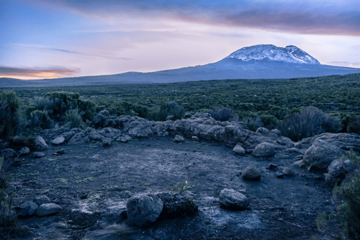
Photo by Slavomir Hepka

Mt. Kilimanjaro rises 19,341 ft. above sea level and is the highest freestanding mountain in the world. Being in Africa, the average temperature is higher, making it one of the few 5000m+ mountains in the world that can be climbed without crampons, ice picks and technical training. In fact, the primary skill level required to summit is simply being in reasonably good shape, which is why over 25,000 climbers a year come to Tanzania and attempt to summit Mt. Kilimanjaro. That said, not everybody makes it to the summit. The Kilimanjaro National Parks department put out statistics showing that of those climbers that tried to summit in 5 days or less, only had a 27% success rate. By contrast, those who take 8 days to summit have about an 85% success rate. In other words, it’s not about how fast you can run the mile, it’s based on how your body acclimates to the higher altitude and the more time you give your body, the greater your odds of success.

Turning 40 this year, my primary motivation for flying solo to Tanzania was not solely recreational. My life lacked a sense of adventure and the idea of traveling alone to Africa and scaling one of the world’s taller mountains seemed to adventurous and frankly a little scary. I’d never climbed anything higher than 14,000 feet and had only done that once. In addition to not knowing how I’d do with the altitude, by going alone, I was to be mixed in with a hodge-podge group of 11 other climbers from around the world. Fortunately, not only did they all speak English at least as a secondary language, but we quickly discovered everybody in the group to be very friendly, open and humorous.

Mt. Kilimanjaro climging group.

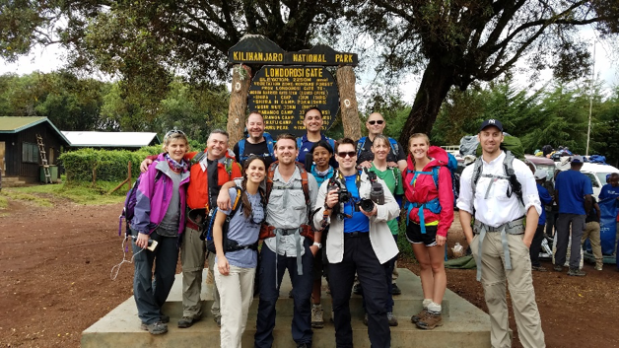
Our climbing group. (That’s me on the right in the white shirt).

In 8 days, I felt like I’d made lifelong friends with almost everybody in the group.

Day 1:  The first day entailed a muddy drive up to the starting point of the hike. We were doing the Lemosho Route, so most of the scenery at the bottom of the mountain was tropical rain forest. It was pretty humid, though already being at about 4,000 feet, it wasn’t as hot as it had been down in Moshi or Arusha, the two closest towns to the base of Kilimanjaro.

Day 2:  On Day 2 you hike for about an hour before you say goodbye to trees for the remainder of the climb. Much of day 2 was filled with what I would describe as overgrown sage brush.

Mt. Kilimanjaro.

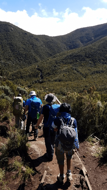
Typical terrain on Day 2.

At the end of Day 2, we were introduced to all of the porters and guides in our group. In all, there were 36 porters (guys that carry a portion of your equipment, food and tents, etc.) and 8 guides.

Days 3-5:  If you’re looking for lush, verdant vistas and valleys, this is not the place. There is no mistaking Kilimanjaro for anything in the Swiss Alps. The terrain is rocky, with very little vegetation and very little protection from the sun. There are some plants you’ll find on Kilimanjaro that cannot be found anywhere else in the world.

Climbing Mt. Kilimanjaro.

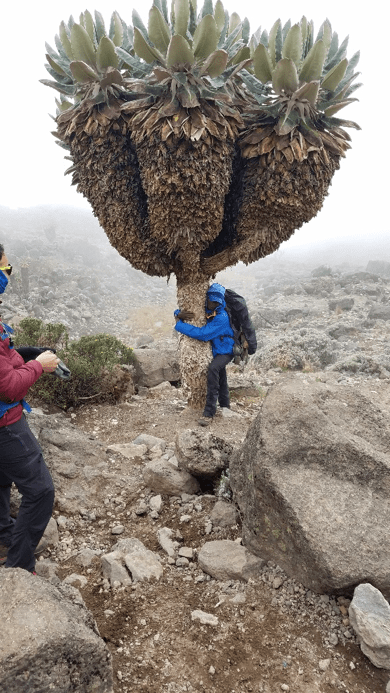
This is the Senecio Kilimanjari plant. Each branch represents 25 years of age – some trees are over 400 years old.

The weather can change quickly as well. We were fortunate that Day 5 was the only day in which we were soaked by a heavy thunderstorm. Nobody’s “rain proof” gear proved completely waterproof and when combined with our sweat from hiking, it made for a soaked day. Most of the day was filled with conversation while hiking, mixed in with a bunch of “pole, pole” reminders from the guides, which is Swahili for “slow, slow”, reminding us that in thin air, going slow will help us adapt better. Our late afternoons and evenings were generally occasioned by a couple of card games, dinner and then hitting the pillow early each night as camp fires were not allowed.

Climbing Mt. Kilimanjaro.

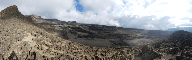
Typical terrain on Days 3-5 of our climb.

Climbing Mt. Kilimanjaro.

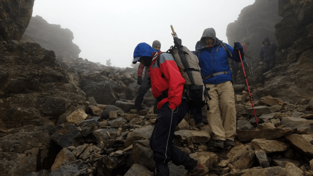
Carefully finding our way.

Days 6-8: Due to the rocky nature of the landscape, we were impressed at how well the porters did in finding flat spots for our tents.

Climbing Mt. Kilimanjaro.

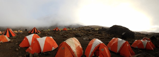
Our camps included facilities for sleeping, eating and a portable potty.

On Day 6, we arrived at the final base camp named Barafu, which is at about 15,331 feet.  The air was noticeably thinner here and we were told to sleep as much as we could before and after dinner as we would begin the final ascent at about 11pm. I was not accustomed to sleeping in the afternoon and my brain refused to sleep. (Side note: It’s not safe to take sleep aids at this elevation). So with no sleep, we started climbing for Uhuru Peak, which was another 4,000 ft vertical climb in the dark, with only headlamps to show the way. The higher we went, the colder it got. I tried sipping from my CamelBak® every 5 minutes or so to keep the line from freezing, however, about an hour before the summit, it froze anyway and the rest of the way I was without water and only had snacks that were frozen solid. Not everything was pain and drudgery however. The star filled sky from the top of Kilimanjaro was magnificent.  I’ve never seen the stars with such clarity and brilliance. The final ascent was quite hard and only through extreme determination and effort did about 2/3 of our group make it to the peak. The other third did so without too much of a struggle.

Summit of Mt. Kilimanjaro.

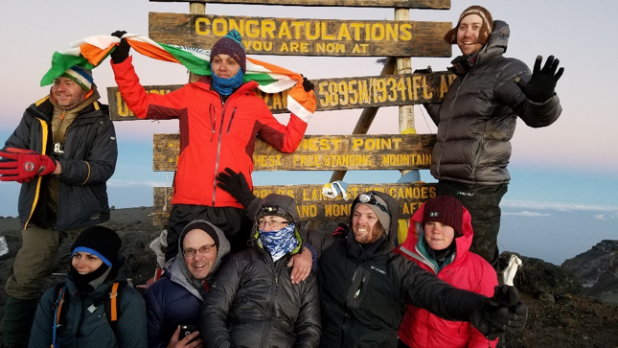
The exhilaration of making it to the top – 19,314 feet above sea level.

I felt extremely fortunate to not feel the heavy toll of the altitude as extensively as most of my hiking comrades. Talking became rare as we approached the summit simply because the expiration of breath cost too much to do so. That is, except for the guides of course who seemed to be well acclimated and accustomed to the hours and the elevation.

Climbing Mt. Kilimanjaro.

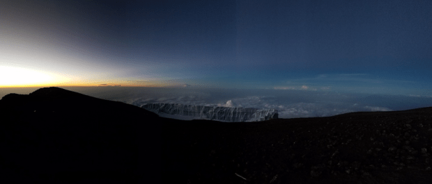
From the summit of Kilimanjaro at sunrise. What a beautiful sight.

Around 6:30am we arrived at the peak, just in time for the sunrise, the dim light revealed a large glacier near the peak and the solemn expanse of a treacherous and rocky peak.

Once you’re at the summit and have taken your pictures, there’s no hamburger joint to hang out at, so after about half an hour of the frigid cold, we headed back down. The journey back down proved to be the most difficult part of the entire hike for me. Upon beginning our descent, I’d now been awake for over 25 hours straight and the exhaustion from a combined lack of sleep and thin air was beginning to be apparent. The descent was steep and filled with loose shale and rocky dust, resembling volcanic ash more than it did a loamy dirt.

About half way down to the Barafu base camp, my knees started to feel the pain of absorbing the stress. I hobbled into base camp at about noon and was told to sleep as we would be doing some more hiking that afternoon. At this point I had a pounding headache, was sweating profusely and had both knees throbbing. 800mg of Ibuprofen didn’t seem to make the slightest dent and I had no hunger for lunch. I didn’t even come close to sleeping that afternoon and around 2pm we headed out for what I thought would be a short hike to get to a lower elevation. Twelve miles later and what felt like a gazillion rocky stairs later, I finally arrived, dead last to the camp. In all my life, I’ve never felt so exhausted. I had gone just over 40 hours without sleep, in some of the most strenuous conditions I’d ever faced. When my head hit the pillow that night, sleep finally came easy and I enjoyed one of the most restful nights of sleep I’d had in years. The next day, I awoke and to my great relief, with sleep my leg muscles had rejuvenated and my knee pain as a result had dissipated about 75% making the last 8 miles of decent feel easy by comparison to the prior day.

When I’d left the U.S., I’d wanted it to be tough. I was looking for a challenge, so in an odd way, I found the grueling descent experience perhaps the most rewarding part of my adventure. Most of the others I should note, did not have similar issues with their knees. I guess that’s my reward for enjoying one too many skiing moguls as a youth.

Climbing Mt. Kilimanjaro.

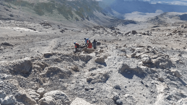
The descent seemed never-ending.

Climbing Mt. Kilimanjaro.

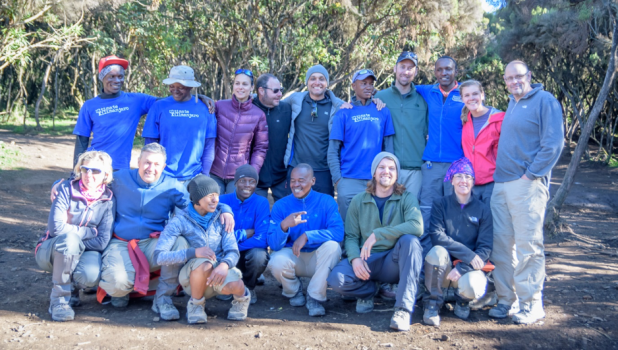
Our tired, but happy group. Photo by Slavo Hepka

Upon returning I’ve been asked by several persons if I’d experienced the adventure I was looking for. Yes, I did. However, on Kilimanjaro I discovered that it’s not simply about experiencing an adventure, it’s about finding the heart of the adventurer inside yourself.  That, my friends, is a thirst I cannot quench, but one in which I’m happy to live the rest of my life pursuing. ‘Til the next great adventure.

Climbing Mt. Kilimanjaro.

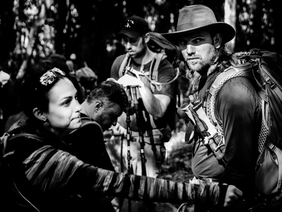
Photo by Slavo Hepka.

Practical Notes:

Season: The Kilimanjaro climbing season is late September through late February, with November – January typically being the best weather.

Tour Company: The company I used was “Ultimate Kilimanjaro”. Of the companies I researched, they had the best combination of overall value, price and expertise. I also added a two-day safari at the start of the trip. Very worthwhile.

Access: Kilimanjaro National Airport, near Arusha. The mountain is near the city of Moshi, about a one hour drive from Arusha.

Route: Our tour company took the Lemosho Route, about 42 miles total, and one of the longer routes. Most of the miles are spent going up and a shorter route is taken coming down.

Preparation: I am in fairly good physical condition, exercising regularly. I hiked 5-10 miles a couple times a week with a 50 lb pack for a couple months prior to the trip. The porters carry most of the camp gear and the group members each carried about 25 lbs of personal gear with them. Most of the group was between the ages of 20 and 50. You do NOT want to have medical attention on this trip. Very difficult to get assistance.

What to Bring: The website provides lots of information. Don’t skimp on the rain gear or warm weather clothing. Also, bring a couple card games for entertainment – there are no campfires so evening entertainment is limited. Solar is the only practical way to charge your electronics (e.g. phone) and lamps, and they will probably not last long each day. Diamox for altitude sickness is very helpful.

Marrakech (or Marrakesh) – The Hub of Morocco

One of the most visited cities in Morocco is Marrakech, and with good reason. There is a lot to do and see here. Marrakech was the crossroads of North African trade routes and the capital of Morocco for centuries. The city dates back to the 12th century.

A street scene in the Medina of Marrakech.

A street scene in the Medina of Marrakech.

Like many old Moroccan cities, the oldest part (called the Medina) of Marrakech is surrounded by a wall with numerous gates. Inside the gates are a maze of narrow alleys and interesting sights.

You have your choice of lamps at this shop in Marrakech's Medina.

You have your choice of lamps at this shop in Marrakech’s Medina.

Outside the Medina, you’ll find the modern Marrakech with beautiful apartment buildings, trendy shopping boutiques and even McDonald’s. It’s like two completely different worlds.

We happened to arrive on the day of Eid al-Adha (Festival of Sacrifice), an Islamic holiday where thousands of sheep all over the country meet their maker, and families cook and share the meat – almost like Thanksgiving! In the city on this day there were small fires everywhere with roasted (and burnt) sheep flesh (including heads and entrails) – what a wonderful smell greeted us!

Some of the sheep fires. Hard to describe the sights and smells through a photo.

Some of the sheep fires. Hard to describe the sights and smells through a photo.

Loads of hides from the freshly slaughtered sheep.

Loads of hides from the freshly slaughtered sheep.

By the end of the next day, most of this celebration mess was cleaned up and the city was pretty much back to normal.

Here are some of the major sights:

Bahia Palace. This palace is not old by Marrakech standards (mid 1800’s) but is beautiful and contains a number of interesting chambers. It was built for grand advisors to the sultan.

One of the reception rooms in Bahia Palace.

One of the reception rooms in Bahia Palace.

One of the many beautifully decorated ceilings in Bahia Palace.

One of the many beautifully decorated ceilings in Bahia Palace.

In the Harem courtyard. Four wives and 24 concubines inhabited this part of the palace.

In the Harem courtyard. Four wives and 24 concubines inhabited this part of the palace.

The quarters of the

The quarters of the “favorite wife”.

El Badi Palace. This huge palace complex is a testament to the wealth gained from the African caravan routes that came through Marrakech. It was built in the late 16th century and is largely in ruins now, but does retain its huge outer walls and some other remnants of structures worth visiting.

A view of the walls and an entrance into the El Badi Palace ceremonial grounds.

A view of the walls and an entrance into the El Badi Palace ceremonial grounds.

The large pool at El Badi Palace.

The large pool at El Badi Palace.

What a place it must have been in its heyday! One of the treasures housed on the grounds is the original minbar (or pulpit) from the Koutoubia Mosque (discussed below). It is an incredible work of art, with thousands of intricate wood designs and carvings, which took eight years to complete. It was crafted in the 1100’s.

The 12th century minbar - eight years in the making! An incredible piece of art and history.

The 12th century minbar – eight years in the making! An incredible piece of art and history.

Jemaa el Fna (The Main Square). This is an open area in the center of the Medina and the hub of Marrakech nightlife. It was interesting to watch it come alive as the sun set.

Sun setting over the Jemaa el Fna.

Sun setting over the Jemaa el Fna.

Food stalls in Jemaa el Fna.

Food stalls in Jemaa el Fna.

This is a city that comes out at night in the main square – with numerous food stalls, snake charmers, a variety of other entertainers, games and all kinds of locals and tourists mingling. A number of surrounding restaurants provide a view over the square, but eating at one of the food stalls is a bit cheaper and provides a good option to rub shoulders with fellow travelers and locals.

Koutoubia Tower & Mosque. Considered the “most perfect minaret” in North Africa and the symbol of Marrakech. The Mosque is not open to tourists, but there are lovely gardens around the mosque. This is an old structure, dating back to the late 12th century.

A view of the Koutoubia Tower.

A view of the Koutoubia Tower.

The Souks. These are mainly just north of the Jemaa el Fna and are fun to wander through. There are hundreds of shops containing all kinds of goods. One wonders how they all stay in business. They are more or less organized by craft. Early morning or late afternoon are the best times to visit.

One of the alleys in the Marrakech souks.

One of the alleys in the Marrakech souks.

City Gates. Bab Agnaou was one of the two original entrances to the citadel or Kasbah of Marrakech – which was the main royal residence or fortress.

The Bab Agnaou gate.

The Bab Agnaou gate.

Saadian Tombs. Near the Bab Agnaou is the Kasbah Mosque and the Saadian Tombs. These beautiful tombs were constructed by the same dynasty (the Saadians, who ruled Morocco from 1554 to 1669) that built the El Badi Palace.

The Kasbah Mosque and minaret.

The Kasbah Mosque and minaret.

Interior detail of the Saadian Tombs.

Interior detail of the Saadian Tombs.

There is usually a line for viewing these tombs, but it moves pretty quickly. Have your cameras ready so you can take your pictures before others are pressing for their turn.

Practical Information: We stayed at a lovely riad (Riad Alnadine), which are old wealthy merchant houses turned into guest residences in the center of the Medina. It’s owned and run by a French couple and was comfortable, with a great rooftop terrace for breakfast and relaxing and enjoying the open air.

Our lovely French hosts and traveling companions in Marrakech, in the courtyard of their riad.

Our lovely French hosts and traveling companions in Marrakech, in the courtyard of their riad.

While no visit to Morocco would be complete without a visit to Marrakech, be sure to visit other parts of this fascinating country. We spent a day and a half exploring the city and then took another day trip to the coastal city of Essaouira (highly recommended) which I will share in a separate post.

Reference: The Lonely Planet Guide to Morocco

Fascinating Fez – Part 2

In addition to those sights mentioned in my first post on Fez, Morocco here are a few others. We enjoyed getting a feel for “real” life in Fez.

Tanneries. One of the highlights of a visit to Fez is a visit to the tanneries. These tanneries are world famous and a real sight to behold. They were the commercial backbone of Fez for hundreds of years. The process hasn’t changed much in all that time, although more sophisticated chemical treatments are used more frequently now rather than the natural dyes used in the past. The workers pass down their knowledge and skills from one generation to the next.

An overlook of Chouwara Tanneries. The white vats in the foreground contain pigeon dung, used to clean the skins.

An overlook of Chouwara Tanneries. The white vats in the foreground contain pigeon dung, used to clean the skins.

If you want to gain a new appreciation for your own job, just observe the workers here for awhile. Although fun to watch, I can’t imagine what life would be like standing in these vats day after day breathing in the strong odors and working in these conditions for a lifetime.

The large Chouwara tannery is located on the southern side of the Medina and while there aren’t signs pointing the way, just ask anyone for directions. There are several viewing areas located above leather goods shops. The proprietors will provide you with mint leaves to alleviate the smells.

A closer look at the Chouwara Tanneries. The workers are constantly moving from vat to vat to keep the skins moving through the process.

A closer look at the Chouwara Tanneries. The workers are constantly moving from vat to vat to keep the skins moving through the process.

Once you have observed the tanning process and workers, you then exit through the huge shops where can buy high quality leather jackets, purses and other leather goods for a pretty reasonable price. Surprisingly, there was no pressure to buy anything. My guess is that with the volume of tourists coming here, the shops do a pretty good business.

We happened by chance upon the Gueliz tannery located in the heart of the Medina. Our book seemed to downplay a visit here but Gueliz was actually a lot of fun and a more intimate experience, since you can walk through the middle of the tanning “factory” and among the workers treating the hides.

The recently skinned sheep hides await the first step in the processing.

The recently skinned sheep hides await the first step in the processing.

A worker in the vats at Gueliz tannery. I am really glad I don't have his job!

A worker in the vats at Gueliz tannery. I am really glad I don’t have his job!

Colored sheep hides laying out to dry. These will be made into shoes, purses and other goods.

Colored sheep hides laying out to dry. These will be made into shoes, purses and other goods.

A worker doing some final processing of the leather before it turns into a product for sale.

A worker doing some final processing of the leather before it turns into a product for sale.

At this tannery there was a Berber side and an Arab side, an arrangement probably dating back among these ethnic groups hundreds of years. We met some Berber families who accompanied their husbands to Fez to work here and were staying at a “hotel” (if you can use that word to describe the living quarters).

The Berber

The Berber “hotel” where families of the tannery’s workers are housed.

Craft shops. On a hillside right behind and above the Gueliz tannery was a craft shop area. When we first entered, we thought it was a slum community and what we found in reality was a beehive of industry – wool, leather, woodworking, and many other crafts. People were everywhere producing and refurbishing many goods.

The craft shops area in Fez.

The craft shops area in Fez.

In the craft shop area - wool, wool everywhere!

In the craft shop area – wool, wool everywhere!

The Jewish Quarter (Mellah). This is an old part of Fez that doesn’t have any sights per se but was fun to wander around, seeing all the old decrepit buildings and signs of a thriving Jewish community.

A view of a main street in the Jewish Quarter, known as Mellah (

A view of a main street in the Jewish Quarter, known as Mellah (“salt” in Arabic).

Fez had a pretty good size Jewish community in the 17th – 19th centuries and there are remnants from this era – some unique architecture, a few Hebrew signs, Stars of David, synagogues and cemetery.

A sign noting this building is a 17th century synagogue.

A sign noting this building is a 17th century synagogue.

Look closely at the decorations on the 2nd story and you'll see a Star of David, and note the year - 1531.

Look closely at the decorations on the 2nd story and you’ll see a Star of David, and note the year – 1531.

It is now an area inhabited by poor Muslim immigrants from the countryside.

Shuttered windows in the Jewish Quarter, which are unique features of this area.

Shuttered windows in the Jewish Quarter, which are unique features of this area.

There are still a few Jewish families here, although most emigrated to Casablanca, France or Israel after Morocco gained its independence from France in 1956.

We had a great hotel in Fez, called Dar Dalila. It was in the Medina, but in a quiet section near the exterior Medina wall. The interior was beautiful and our room was large and comfortable. I highly recommend this location. Nearby was a covered car park since a car is pretty much useless in the Medina.

The reception room in Dar Dalila.

The reception room in Dar Dalila.

Our room in Dar Dalila.

Our room in Dar Dalila.

Fez is definitely one of the highlights of a visit to Morocco and one of the most unique and fascinating places to visit in the world.

Reference: The Rough Guide to Morocco.

Fascinating Fez – Part 1

There’s so much to see in Fez I’m breaking this post into two parts. We arrived in Fez from Meknes (about 43 miles or 69 km). Fez was one of four imperial capitals of Morocco and was regarded as one of the holiest cities in the Islamic world due to its connection with Moulay Idriss who founded the city the late 8th century (see my post here for a little information on him). Travelers have been coming to Fez for a 1,000 years, its reputation as a center of learning religious heritage was known far and wide. Fez is a large city, and like most Moroccan cities it has a newer part (Ville Nouvelle) built by the French during their colonization period and an older section (the walled portion of the old city known as the Medina), which is huge, and is split into two parts (Fez el Bali and Fez el Jedid). Fez’s Medina is called the most complete medieval city in the Arab world. The streets and narrow alleyways wind all over and are intriguing to wander – don’t be surprised if you get a bit lost.

An centuries-old water clock in Fez. It has 12 windows and the outside is being restored, but no one really knows how it functioned.

An centuries-old water clock in Fez. It has 12 windows and the outside is being restored, but no one really knows how it functioned.

There are maps of the Medina available and the locals will help you out too. All kinds of fun things lurk behind almost every corner. We wandered into a small tannery area by accident (I was just peeking through a gate) and got a fascinating tour.

A hidden leather working area near a small tannery run by Berbers in old Fez.

A hidden leather working area near a small tannery run by Berbers in old Fez.

At another point we were taken up on top of a person’s house for a great view over the city.

A view of Moulay Idriss II's tomb from the roof top of a local's home we visited.

A view of Moulay Idriss II’s tomb from the roof top of a local’s home we visited.

The entrance to the tomb of Moulay Idriss II, a holy site in Islamic culture. He was the son of the founder of Fez and lived in the 9th century. He established Fez as a place of refuge for muslims retreating from Spain and other places.

The entrance to the tomb of Moulay Idriss II, a holy site in Islamic culture. He was the son of the founder of Fez and lived in the 9th century. He established Fez as a place of refuge for muslims retreating from Spain and other places.

Here as some of the highlights of Fez (more to come in another post). Walls and Gates. If you love medieval settings as much as I do, Fez will take you back in time. There are huge gates and walls everywhere and I didn’t figure out how they all connect. We wandered outside the walls in a few sections to get a feel for their extensiveness.

One of the main gate towers of Fez, known as Bab Sagma.

One of the main gate towers of Fez, known as Bab Sagma.

The gate known as Bab Boujeloud.

The gate known as Bab Boujeloud.

A market by the walls of Fez.

A market by the walls of Fez.

Merenid Tombs. Just outside the walled city on a hillside are the ruins of the Merenid tombs, former rulers of Fez in the 13th century. While the ruins aren’t much, the views overlooking the old city are terrific. There are 365 mosque minarets in Fez, but we didn’t try to count them.

A view of Fez and its old walls from the Merenid Tombs.

A view of Fez and its old walls from the Merenid Tombs.

Ruins of the Merenid Tombs.

Ruins of the Merenid Tombs.

Medersas. Medersa means “place of study”. These were student colleges and used largely as residence halls, since most teaching would be done in the mosques. Fez was a great center of learning and the architecture of these halls is stunning. We visited two. The layout is similar – a main courtyard, student cells, prayer hall and oratory. Medersa Bou Inania. This is one of the highlights of a visit to Fez. The dark cedar wood, tile work and stucco is beautiful. This building is the city’s only building still in religious use that non-muslims are permitted to enter. It was built in the 14th century.

Detail of the intricate carvings at Medersa Bou Inania.

Detail of the intricate carvings at Medersa Bou Inania.

A view of the courtyard of Medersa Bou Inania.

A view of the courtyard of Medersa Bou Inania.

Medersa el Attarine. This building was completed in 1325 and is also beautiful.

The courtyard of Medersa el Attarine.

The courtyard of Medersa el Attarine.

Another view of the courtyard of Medersa el Attarine showing the tile work.

Another view of the courtyard of Medersa el Attarine showing the tile work.

The narrow alleys of the Medina. As mentioned above, just wandering around the old Medina is fun. There are also a few squares where the locals gather.

The buildings are almost touching in this narrow Fez Medina alleyway.

The buildings are almost touching in this narrow Fez Medina alleyway.

Another alleyway in the Medina.

Another alleyway in the Medina.

A small square in the old Medina - Place en Nejjarine. There is a large museum in the background.

A small square in the old Medina – Place en Nejjarine. There is a large museum in the background.

Another small square, called Place Seffarine with copper pottery being created.

Another small square, called Place Seffarine with copper pottery being created.

In my next post, we’ll explore the tanneries – one of the most interesting sights to behold anywhere in Morocco and also the Jewish Quarter, a dilapidated part of Fez that is pretty much off the tourist radar. For a map of locations visited in Morocco, click here.

Climbing Mt. Sinai – An Unforgettable Experience

One of our most memorable experiences in Egypt was visiting St. Katherine’s Monastery and climbing to the summit of Mt. Sinai. It’s about a two and a half-hour drive through the unforgiving interior desert landscape from the resort of Na’ama Bay to St. Katherine’s Monastery, where the hike begins to Mt. Sinai.

A view of the Sinai peninsula landscape on the way to Mt. Sinai.

A view of the Sinai peninsula landscape on the way to Mt. Sinai.

St. Katherine’s Monastery

This area has been a pilgrimage site for centuries and is holy ground to three religions: Christians, Muslims, and Jews. According to the Old Testament, this is the place of numerous revelations by God (including the Ten Commandments) to the prophet Moses. The Israelites camped in this area for some time after miraculously escaping from the Egyptian armies by crossing the Red Sea on dry land.

The Bell Tower at St. Katherine's Monastery. It houses 9 bells donated by Tsar Alexander II from Russia.

The Bell Tower at St. Katherine’s Monastery. It houses 9 bells donated by Tsar Alexander II from Russia.

Considered one of the oldest continually functioning monastic communities in the world, much of the compact monastery is off limits to tourists, but it is still worth a visit and is the spot where all tourists begin their hike up Mt. Sinai.

A view of the Monastery walls and some local camels.

A view of the Monastery walls and some local camels.

The 20 or so monks living here are Greek Orthodox and the first church was built here in about 337 AD, commemorating the spot where God spoke to Moses in the form of a burning bush. Interestingly, a descendant of an evergreen bush which grows nowhere else in the Sinai is found here.

This evergreen is believed to be a descendant of the burning bush. Transplanted here in the 10th century from the nearby chapel of the same name.

This evergreen is believed to be a descendant of the burning bush. Transplanted here in the 10th century from the nearby chapel of the same name.

The Byzantine Emperor Justinian fortified the location and built the main Basilica of the Transfiguration in 527 AD on the grounds of the original church which became the origin of the monastery.

Mt. Sinai

There are two ways to climb the Mount (altitude: 2,285 meters or 7,500 ft). There is the “camel path” which is wider and more “gently” sloping, or taking what is called the “Steps of Repentance” route– a very steep climb of 3,750 steps (hard on the knees) which was built by a monk doing penance—what a price to pay! We took the camel path, and it joins the “Steps of Repentance” path 750 steps below the summit.

On the trail with Mount Sinai behind me - about halfway up.

On the trail with Mount Sinai behind me – about halfway up.

Going through a narrow gorge. Getting ready for the final ascent.

Going through a narrow gorge. Getting ready for the final ascent.

Hiking up the last 750 steps to the summit. In the distance below is Elijah's basin. The cypress tree is thought to be 1,000 years old. Those who traveled with Moses up the mountain waited here while he ascended to the summit to speak with God.

Hiking up the last 750 steps to the summit. In the distance below is Elijah’s basin. The cypress tree is thought to be 1,000 years old. Those who traveled with Moses up the mountain waited here while he ascended to the summit to speak with God.

You can take a camel up the path but we decided to hike it, and even at a good pace it took us about 2 hours to reach the summit from the Monastery. This is not an easy hike, and several members of our group ended up not making it to the top.

The Chapel of the Holy Trinity at the summit of Mt. Sinai.

The Chapel of the Holy Trinity at the summit of Mt. Sinai.

A magnificent view from the top of Mt. Sinai.

A magnificent view from the top of Mt. Sinai.

A lot of tourists leave at around 3 am to reach the summit for the sunrise. We were not that ambitious and arrived at the summit around noon. My wife and I had the top of this sacred mountain to ourselves at that time of day. The views are incredible and although the landscape is harsh (reminding me a bit of Death Valley), it was thrilling to be on the Mount which holds so much historical and religious significance to many people.

References: Lonely Planet Egypt, DK Eyewitness Travel Egypt.

Karnak, Egypt – “The Most Perfect of Places”

Entrance to Karnak along the Avenue of the Sphinxes (which runs all the way from Luxor).

Entrance to Karnak along the Avenue of the Sphinxes (which runs all the way from Luxor).

Karnak is Egypt’s greatest temple complex and is considered the most important Pharaonic site after the Pyramids of Giza. It was also the most important place of worship in Egypt from approximately 1500 – 1000 BC. It was called “Ipet-Isut” meaning “The Most Perfect of Places.” Karnak was built over a period of about 1,300 years, starting around 2125 BC.

Remants of the original paintings in the Great Festival Hall of Tuthmosis III.

Remants of the original paintings in the Great Festival Hall of Tuthmosis III.

During the reign of Ramses III, 80,000 people worked at or on the complex as laborers, servants, guards, priests and many other functions.

The huge Hypostyle Hall at Karnak.

The huge Hypostyle Hall at Karnak.

Note the size of the people in the distance - Karnak Temple is on a huge scale.

Note the size of the people in the distance – Karnak Temple is on a huge scale.

Karnak's Sacred Lake, where priests purified themselves.

Karnak’s Sacred Lake, where priests purified themselves.

Temple of Ramses III at Karnak.

Temple of Ramses III at Karnak.

The scale of the site (about a square kilometer) is massive and there’s a lot to explore here. Be sure to take the time to go to some of the outer ruins. Karnak is just 2 kilometers north of Luxor (see my post on Luxor here), also on the east bank of the Nile. Both Luxor and Karnak can be visited in one day.

Statues of Karnak at night.

Statues of Karnak at night.

There is an evening sound and light show that was quite good. The show included walking through the massive complex at night, which was a blast and gave the place an entirely different feeling.

Sources: Information at Karnak Temple, DK Eyewitness Travel Egypt, Lonely Planet Egypt.

Overlooking the Karnak Temple Complex and Sacred Lake at night.

Overlooking the Karnak Temple Complex and Sacred Lake at night.

Exploring Dahshur and Saqqara – Egypt as it was a Hundred Years Ago

If you’d like to get away from the crowds in Cairo, and feel almost like you’re an early explorer in Egypt, take a short trip to Dahshur and Saqqara. These are “don’t miss” sights and an easy day trip (the furthest site, Dahshur, is about 23 miles south from Cairo, we hired a driver and van from Cairo to take us to these sights).

Dahshur

Dahshur originally contained 11 pyramids, and the oldest are the main attractions. The Red Pyramid and the Bent Pyramids were built around 2600 BC, making them slightly older than the pyramids of Giza. They are almost as large as the more famous pyramids at Giza, both are only about 14 feet shorter than the Pyramid of Khafre (the 2nd highest pyramid at Giza). They were the first “true” pyramids the Egyptians built.

The Red Pyramid - picture perfect with a camel!

The Red Pyramid – picture perfect with a camel!

The Bent Pyramid was built first, and the builders learned during construction that they had to lessen the steepness of the angle of the sides due to stability issues and the adjustment gives the pyramid its unique shape.

The Bent Pyramid - not accessible to tourists.  The angle was reduced from 54 to 43 degrees due to stress and instability.

The Bent Pyramid – not accessible to tourists. The angle was reduced from 54 to 43 degrees due to stress and instability.

The Red Pyramid is open to the public, the Bent Pyramid is not, since it is on a military reservation.  I loved visiting the Red Pyramid—it looks untouched with sand still covering the huge stone blocks part way up the sides and inside we had the interior chambers all to ourselves.

The corbelled ceilings in the Red Pyramid chambers. Hard to get a good perspective with a photo.

The corbelled ceilings in the Red Pyramid chambers. Hard to get a good perspective with a photo.

The entrance to the Red Pyramid is in the distance.

The entrance to the Red Pyramid is in the distance.

Saqqara

Just about 6 miles north of Dahshur is Saqqara, the burial site for the ancient city of Memphis, just a short distance away. This was a burial ground for 3,500 years, and was largely buried in sand until the mid-1800’s. Saqqara is home to the Step Pyramid, built in 2650 BC, and it is the oldest stone monument in Egypt and quite possibly the world.

My in-laws in front of the Step Pyramid. The pyramid's interior is not open or safe enough for visitors.

My in-laws in front of the Step Pyramid. The pyramid’s interior is not open or safe enough for visitors.

The Step Pyramid was part of a progression in construction technology that led to the smooth-sided, near perfectly-dimensioned pyramids of Dahshur and Giza just a hundred years later.

The entrance to the Tomb of Mereruka, one of the many tombs at Saqqara.

The entrance to the Tomb of Mereruka, one of the many tombs at Saqqara.

Inside the Tomb of Mereruka, there are 32 chambers in this tomb.

Inside the Tomb of Mereruka, there are 32 chambers in this tomb.

Inside the Pyramid of Teti at Saqqara (about 2300 BC) - note the Pyramid Texts on the walls.

Inside the Pyramid of Teti at Saqqara (about 2300 BC) – note the Pyramid Texts on the walls.

Saqqara is a huge site, you will have to pick and choose what you see, and some tombs may be closed on a rotating basis. There were a few tour buses here, but not many, and since the site is spread out, you may find yourself enjoying the tombs on your own. Be prepared to stoop, crawl, and get a bit dusty in entering some of the tombs – part of the fun!

The Pyramids of Abu Sir, looking north from Saqqara. The most northern one, Pyramid of Sahure, was open to tourists at the time, not sure if it still is.

The Pyramids of Abu Sir, looking north from Saqqara. The most northern one, Pyramid of Sahure, was open to tourists at the time, not sure if it still is.

References: Lonely Plant Egypt and DK Eyewitness Travel Egypt

Giza Plateau – Home to the Greatest Wonder of the World

Regardless of which list of the “Wonders of the World” you consider your favorite or the most accurate (my son and I have argued about this), the Pyramids of Giza have to be on every list. For most tourists flying into Cairo, Egypt the first sight you see as your plane turns to make its approach into the Cairo International airport are the Pyramids at Giza. They look a bit surreal from the air, and I could hardly believe my eyes, seeing these massive structures for the first time. The scale and magnificence of the Pyramids of Giza pretty much defy description.

This photo of me by the Great Pyramid of Khufu (or Cheops) puts into perspective how massive these structrues are.

This photo of me by the Great Pyramid of Khufu (or Cheops) puts into perspective how massive these structrues are.

We still don’t really know how the ancient Egyptians (more accurately their slaves) managed to build these structures, with almost perfect engineering strength and accuracy. Built with stone blocks that weigh 2.5 to 15 tons, they have been standing almost 5,000 years. The greatest difference in the length between the four sides of any pyramid is 2 inches.  The largest pyramid is 450 feet high.

The Great Pyramid. 450 feet high. The haze is the smog of Cairo - which was very bad on the day of our visit.

The Great Pyramid. 450 feet high. The haze is the smog of Cairo – which was very bad on the day of our visit.

All this said, Giza was probably my least favorite spot of the places we visited in Egypt simply because the tourist crowds and smog of Cairo made our visit a little less appealing.  My favorite pyramids were south of Giza and Cairo, in Dahshur and Saqqara, which I will cover in another post. The main sights at Giza (which is just south of the Cairo suburbs), include the three large pyramids made so famous in many pictures and the Sphinx sculpture.

My in-laws at the Sphinx (Great Pyramid of Khufu in the background).

My in-laws at the Sphinx (Great Pyramid of Khufu in the background).

The three large pyramids are: The Great Pyramid (also known as the Pyramid of Khufu or Cheops), Pyramid of Khafre (Khufu’s son), and the relatively smaller third pyramid called Menkaure, who was Khafre’s successor).

The third of the great pyramids, Pyramid of Menkaure. It's quite a distance from the other two to this one (the little pyramid at the left is one of his queen's tombs).

The third of the great pyramids, Pyramid of Menkaure. It’s quite a distance from the other two to this one (the little pyramid at the left is one of his queen’s tombs).

These pyramids were built as tombs during 2600 – 2100 BC, making them over 4,500 years old. These were not the first pyramids built in Egypt, the oldest is the Step Pyramid (King Djoser’s Pyramid) in Saqqara (2665 BC). While these pyramids are the main attractions at Giza, there are other less-visited sites such as the much smaller Queen’s pyramids which are more intimate and fun – very few tourists visit these tombs, which are near the largest (Great) Pyramid.

In front of the Queen's pyramids next to the Great Pyramid.

In front of the Queen’s pyramids next to the Great Pyramid.

The Giza site is very spread out and somewhat confusing – there is no signage to speak of and I got differing directions as we tried to find a few other tombs (such as the Tomb of Khentkawes).

I believe this is the Tomb of Khentkawes, which was closed.

I believe this is the Tomb of Khentkawes, which was closed.

At the time we visited a few years ago, it was possible to only visit one pyramid on a given day (they also rotate closures), and we were able to visit the Pyramid of Khafre, the 2nd largest (slightly smaller than Great Pyramid, even though it looks larger).

My mother-in-law and wife in front of the Pyramid of Khafre. It's the only one with a bit of the brillant outer limestone layer left at the top.

My mother-in-law and wife in front of the Pyramid of Khafre. It’s the only one with a bit of the brillant outer limestone layer left at the top.

I could not get a picture inside this pyramid, and the tunnel is very long and steep.  Be prepared to stoop as you climb the whole tunnel length. It is also humid and stuffy in the main room.

Climbing out of the Queen's Pyramid, giving an idea of what the access tunnels are like.

Climbing out of the Queen’s Pyramid, giving an idea of what the access tunnels are like.

There really isn’t much to see, other than the sarcophagus of the Pharaoh Khafre, but it’s one of those things you have to do!  If you’re claustrophobic it’s probably a good idea to stay outside.  For an overview of places we visited in Egypt, click here.

My brother-in-law doing the touristy thing (why not?) in front of the Pyramid of Khafre.

My brother-in-law doing the touristy thing (why not?) in front of the Pyramid of Khafre.

References: DK Eyewitness Travel Egypt, Lonely Plant Egypt.