Ireland Day 4: Ring of Kerry

The rugged Atlantic coastline of the Ring of Kerry, Ireland.

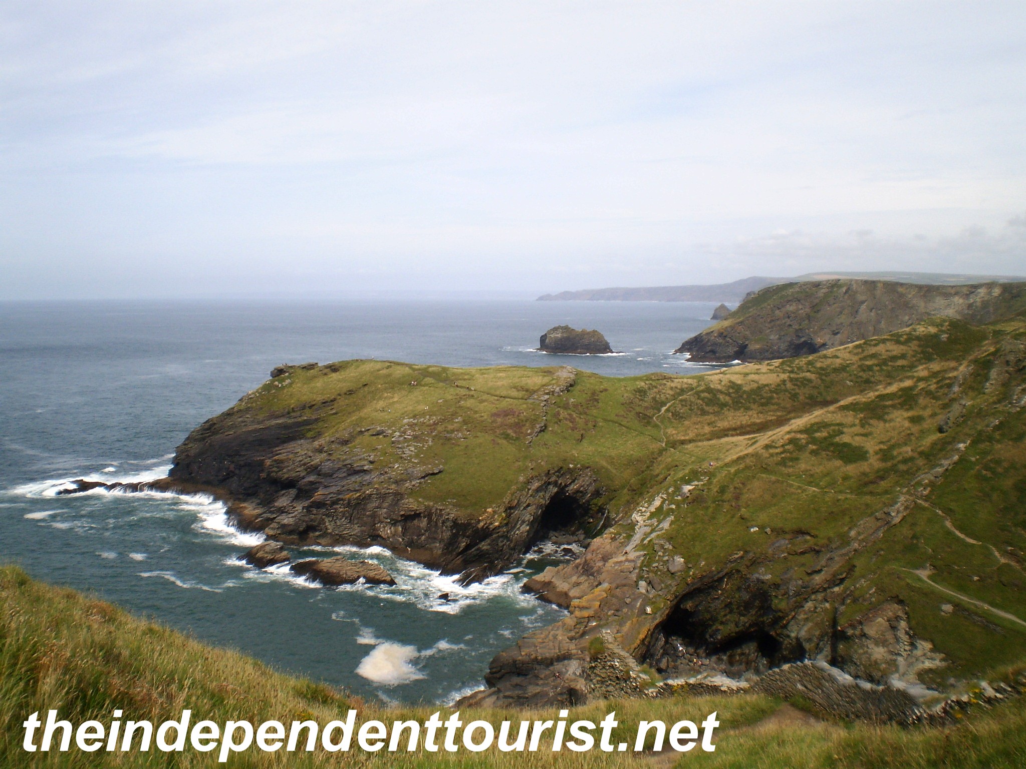
Located on the southwest coast of Ireland, the famous Ring of Kerry is one of Ireland’s most popular attractions (it’s called the “Ring of Kerry” since Iveragh Peninsula is part of County Kerry). Like the Dingle Peninsula, it provides the tourist with a great combination of historical sights and natural scenery. On our fourth day in Ireland, we took the 120 mile drive around the peninsula.

Kenmare

Our B&B in Kenmare

Our base for exploring this area was the little town of Kenmare, south of Killarney, and a good jump-off spot for touring the Ring (see map below). Many people stay in Killarney to visit this part of Ireland, but if you prefer a little quieter location, try Kenmare. We stayed in a great B&B, just outside the town. No problem finding good food here. We found an excellent Italian restaurant right on the main street. In the town of Kenmare, just off Market Street is “Druid’s Circle” a prehistoric stone ring of 15 stones associated with human sacrifice.

The Druid stone circle in Kenmare. Note the altar in the middle right.

Ring of Kerry

Since we were visiting in late March, crowds were not a problem on the Ring road, but from what we understand, there are LOTS of tour buses in the summer, so be prepared for slow driving and a lot of people. Rick Steves recommends going clockwise on the Ring (against the tour bus flow) in order to avoid the crowds if visiting in the summer, and this is probably a good idea.  We went this way even though the traffic was light during our visit.

An old castle-home off the road on the Ring of Kerry.

Below are a few of the sites we saw on this road trip.

Ring Forts

We visited Staigue Fort (on the south side of the peninsula), and the Cahersiveen forts (on the north side of the peninsula, near the town of Cahersiveen). These forts were built between 500 BC and 300 AD.  Not much is known about the builders, but apparently they were defensive shelters in times of tribal warfare.  They were built without mortar, and are large structures—walls are 12 feet thick at the base and up to 20 feet high. All of these forts are just a mile or two off the main route.

Exterior view of Staigue Ring Fort.

Inside Staigue Ring Fort.

The huge ring fort near Cahersiveen.

Skellig Michael

At the western end of the Ring of Kerry is the jump-off spot to Skellig Michael, one of the three prominent “St. Michael” monasteries in Europe (the others being Mont St. Michel in Normandy, France, and St. Michael’s Mount in Penzance, England). St. Michael is the patron saint of high places, hence why these three sites are named after him. The downside of visiting Ireland in March is that no boats were operating out to Skellig Michael (about 10 miles off the coast). They do not begin service until after Easter, and even then, getting a boat is iffy, and dependent on the weather. Monks lived on Skellig Michael from 600 AD to the 12thcentury. If you are going to Skellig Michael, you will need to stay in Portmagee overnight, or awake VERY early and drive approximately 60 miles from Killarney or Kenmare  out to Portmagee.

Skellig Michael in the distance from the western edge of the Ring of Kerry.

Ballycarberry Castle

Close to Cahersiveen is this ruined, ivy covered castle, which is a fitting symbol of Ireland.  We just happened to see a sign pointing to the castle and decided to check it out, one of the benefits of having our own car.

The ivy covered ruins of Ballycarbery Castle.

Ross Castle

Near Killarney is Ross Castle. It has an imposing setting right on the shore, on an isthmus in Lough Leane, which separates this large lake into two parts. The castle was built in 1420.  Inside the castle several rooms provide great examples of medieval construction methods for ceilings, showing the use of wood lath, plaster and the curvature of the wooden frame to provide strength.

Ross Castle, hear Killarney.

Killarney is in such a unique perfect setting with mountain peaks (over 2000 feet high), lakes, Killarney National Park, and the Ring of Kerry.  No wonder this is such a popular tourist destination.

References: Rick Steves’ Ireland, 2007, and DK Eyewitness Travel, Ireland, 2006.

Key sights on Ring of Kerry, Ireland.

Ireland Day 3: Dingle Peninsula

The narrow road that winds around Dingle Peninsula.

The farming country of Dingle Peninsula. There are more sheep than people in this remote part of Ireland!

From the town of Dingle, we drove around the peninsula counter-clockwise.  We had most of the road and stopping points to ourselves (we were there in late March), and enjoyed the great views of the rugged coast and the now uninhabited Blasket Islands (the village on the main island is now a ghost town). The government thought it best to move the last of the residents from the Blaskets to the ‘mainland’ in 1953. There are also some interesting historical sites in this remote and windswept part of the Emerald Isle, which provides a feel for the Ireland of yesteryear.  A drive around the end of the peninsula with stops will take about 3 hours, although it is only about 30 miles. This part of Ireland is Gaelic-speaking (yes, English is spoken too).

The Dingle Peninsula, Ireland

The Ring of Kerry to the south is more famous and well-traveled, but the scenery on the Dingle Peninsula is beautiful and a bit less touristy.

Here is a pictorial tour, driving west from the town of Dingle…

The "Beehive Huts" on Dingle Peninsula - thought to be early Christian huts built for pilgrims visiting the area.

The beautiful coastline, with the green manicured hills and very blue waters of the Atlantic:

Coming up to Dunmore Head, the westernmost point in Europe.

Dunquin Harbor, on the Dingle Peninsula coastline. In the right side of the picture there is a ramp for a ferry that goes out to the Blasket Islands. Farmers from the Blasket Islands would dock here (until residents were moved off the islands in 1953), and hike 12 miles to the town of Dingle to sell their produce. This area (but not the Blasket Islands) was affected by the potato famine of 1845.

Some interesting historical sites include the ancient churches:

The Church of Kilmalkedar, a 12th century Irish Romanesque church, with a very old cemetery that pre-dates this church.

The vertical stone (below) that Robyn and I are touching is called an ogham stone (900 years older than the Church of Kilmalkedar), and has a script carved onto it that was used in the 3rd to 7th centuries. The stone marked a pre-Christian grave, and a hole in the top of the stone (where Robyn and I are touching thumbs) was a place where people would come to covenant with one another, standing on the graves of their ancestors.

The ancient ogham stone.

The Gallarus Oratory, which is 1,300 years old, is a marvel of watertight stone construction. The stonework is dry-stacked (no mortar).

The Gallarus Oratory, built about 700 AD.

Historical information references: Rick Steve’s Ireland 2007 and DK Eyewitness Travel, Ireland, 2006.

Ireland Day 2: From Limerick to Dingle Peninsula

On our second full day in Ireland we visited King John’s Castle in Limerick, the Village of Adare (and  Desmond Castle), and Ardfert Cathedral, before making our way to the town of Dingle on the Dingle Peninsula.

Our stops on Day 2

Limerick is not a real tourist destination; it’s more of working city, and the third largest in Ireland. King John’s Castle near the center of town looks better from the exterior than the interior. The interior is mainly set up for modern exhibits. The castle was built in 1200 by King John (of Magna Carta fame). It does have a great setting on the River Shannon.

King John’s Castle on the River Shannon

From Limerick we drove south to the little village of Adare, which is considered one of Ireland’s prettiest villages. It is a quaint village with thatched roof houses, with Desmond Castle (often called Adare Castle) on the outskirts, in addition to the famous castle-hotel of Adare Manor, which is one of the “1,000 Places to See Before You Die” in the book by Patricia Schultz (she actually lists 29 sites in the Republic of Ireland, a pretty good share of the 1,000!).

Desmond Castle, Adare

Looking at the Great Hall, Desmond Castle

Ardfert Cathedral is part of the Heritage Ireland system and the Cathedral ruins date from the 12th century, although a monastery was believed to have been founded here in the 6thcentury by St. Brendan the Navigator, who legend says visited the American continent (there is actually some evidence of this in Connecticut, in an archeological site called the “Gungywamp”). There are three medieval churches on the site today, and a short walk away you will find the very substantial ruins of a Franciscan Friary. Ardfert is good for quick stop if you like medieval church buildings. As with many other locations, this site is completely ignored by Rick Steve’s book on Ireland, although he does share some information on St. Brendan.

The intricate Romanesque doorway of the Ardfert Cathedral

Ardfert Cathedral

Franciscan Friary near Ardfert Cathedral

From Ardfert, we drove southwest to the Dingle Peninsula and the town of Dingle, on the southwest side of the peninsula. This drive is quite pretty, with the rolling hills, sheep grazing in the green pastures and views of the sea coast as you get closer to Dingle. A few miles east of Dingle and off the road a mile or so to the south is the little ruin of Minard Castle, a jump-off point in medieval times for sailing to the pilgrimage destination of Santiago de Compostela in northern Spain. This castle is in a cow pasture, and we treaded lightly to avoid any trespassing issues. The castle sits above a beautiful beach (Storm Beach) and bay.

Minard Castle near the town of Dingle

Ireland Day 1: Newgrange, Trim Castle and Bunratty Castle

After arriving in Dublin the prior evening and staying in a B&B close to the airport, we drove north to  Newgrange (about 55 km, near the town of Drogheda) and then southwest to the town of Trim, home of Trim Castle (another 45 km).  Finally, we drove all the way down to Limerick (about 233 km), visiting nearby Bunratty Castle in the late afternoon, and then spent the night in the Limerick area.

Newgrange. This unique burial ground dates from 3200 BC and much of it is intact, having escaped invaders over the centuries until it was discovered in 1699. Excavations took place in the 1960’s. This burial site is 500 years older than the pyramids of Giza, Egypt. It’s hard to get good pictures here, since access is tightly controlled and no pictures are allowed inside. The site consists of an entrance into the mound and a 62 foot long passageway to a small circular burial chamber, with a corbelled stone roof that has kept the chamber dry for 5,000 years. There is a small opening over the entrance door that is aligned such that on Dec. 21st (winter solstice) natural sunlight illuminates the long passageway and all the way into the chamber for 17 minutes—the world’s oldest solar observatory.  Many of the interior stones lining the passageway are decorated with geometric and circular patterns. Since we visited in March, we had no problem gaining access to the tomb (the only way to visit is with a tour guide from the Visitor’s Center), but I understand during the summer the lines can be long, so plan accordingly. There is a shuttle bus from the Visitor’s Center up to the site.  Newgrange is part of the Heritage Ireland system.

The Newgrange burial mound, entrance is on the right side. 3200 BC.

The entrance to Newgrange burial tomb. Note the small opening above the doorway where the sunlight of the winter solstice lights the passageway and tomb. Also, the horizontal stone in front is decorated with ancient geometric designs

Trim Castle.  One of my favorite historical movies is Braveheart, about William Wallace (played by Mel Gibson), the Scottish patriot who fought for Scottish independence against King Edward I in the 1200’s. The castle was used in the movie as a setting for York, England. It was built in the 12thcentury and is the largest Norman castle in Ireland, meant to keep the Irish at bay after the Norman conquest of the British Isles. The tower keep is 70 feet high and has 20 sides, which provided defensive views in every direction.  The castle is set next to the River Boyne, and across the river part of the original town wall also remains. The only way to visit the inside of the Keep is by guided tour, which is twice per hour.  Having been in many castle keeps, we did not take this tour, and just wandered around the castle grounds. Trim Castle is also part of the Heritage Ireland system.

A view of the old city gate and Trim Castle in the distance

A view of Trim Castle from across the River Boyne

The huge walls defending Trim Castle

Bunratty Castle.  Rick Steves (travel book author) says to bypass this castle and adjacent Folk Park. Although this site is a bit touristy, I think it’s worth the visit. The castle was built in the 1400’s and the interior has been restored to the era of the early 1600’s. It’s privately owned (not part of Heritage Ireland). We did tour the interior, which has some unusual chandeliers. Medieval dinners and show are held in the castle, which we debated attending that evening.  However, the cost at the time was about $100/person, and $300 for the 3 of us seemed a bit steep, so we passed up the opportunity. There is also a Folk Park next door to the castle, showing rural life in Ireland at the end of the 19thcentury. You can wander into the shops and houses to get a feel for life during that era.

Bunratty Castle (near Limerick)

References: DK Eyewitness Travel Ireland 2006, Rick Steve’s Ireland 2007.

Eight Day Tour of Ireland

Franciscan Friary near Ardfert. There are many medieval church ruins throughout Ireland.

I suggest considering Ireland as an alternative to the more popular (and crowded) tourist magnet of England. It has just about everything for the European tourist: natural beauty, well-preserved ancient forts and castles, friendly people, hearty food and good infrastructure. We visited Ireland in the month of March, during Spring Break, since it was our son’s high school “graduation trip.” March was a good time to visit, with few tourists and cool but reasonable weather; although the downside is that some sites are not open. We decided to concentrate on southern Ireland. With my love of history, we focused on historical sites and some of the natural beauty of this country.  In future posts, I will provide more detail about our tour locations.

Our tour of Ireland

Our self-guided tour was counter-clockwise from Dublin and covered a lot of ground in 8 days: We flew into Dublin and drove north to Newgrange (prehistoric site from 3200 BC), on to Trim Castle (used in Braveheart), then to Limerick (Bunratty Castle), Dingle Peninsula, Ring of Kerry, Kinsale (close to Cork and Blarney Castle), Waterford (think crystal), Cashel, Kilkenny, Glendalough and finally back to Dublin.

Don’t miss the following:

Killarney and Ring of Kerry.  A classy town and beautiful setting next to high peaks and the Lakes of Killarney. Killarney is the gateway to the Ring of Kerry, which is loaded with historical spots and natural beauty. The western end of the Ring is the jump off point to Skellig Michael, an island monastery dating to 600 AD. I would have killed to get out there, but boats do not go out to the island until after Easter, and even then only when the seas are calm enough to do so.

Coastline of Ring of Kerry

Dingle Peninsula. Some of the bluest water I have seen anywhere was along the coast of this Peninsula just north of the Ring of Kerry.

Blarney Castle.While it is too touristy for my tastes, this is a great castle. I refused to kiss the Blarney Stone (at the top of the castle keep), but if you want the “gift of gab” go for it.

The world famous Blarney Castle

Rock of Cashel.This is one of the great medieval sights in the world, bar none. Home to the kings of Ireland for centuries, it sits on a rock outcropping above the town of Cashel in stunning fashion.

The stunning Rock of Cashel

Glendalough. I love the combination of history and natural beauty. A pristine setting for the monastery among the valleys and lakes, south of Dublin.

The Book of Kells, at Trinity College in Dublin. This richly illustrated book of the Four Gospels was written by monks in 800 AD and is now preserved in this historic university in Dublin.

Some tips for visiting Ireland:

Get a Heritage Ireland Card.  Like English Heritage, this card allows access to many historical sites for one fee. Cards can be purchased at your first site. Visit www.heritageireland.ie for more information.

Cost. Some people are surprised to find out that the Republic of Ireland is on the Euro. It is NOT part of Great Britain (as compared with Northern Ireland). Prices are pretty high in Ireland, although I think the UK is more expensive. Expect to pay about €35 per person for B&B’s. The upside is that Ireland is less visited than Great Britain.

Accommodations. Hotels are few except in the larger cities, and for the most part, Bed & Breakfasts are the norm. We did stay in a couple Travelodge hotels (Waterford and Dublin Airport) with decent, relatively inexpensive rooms. We enjoyed the places we stayed and found the proprietors very welcoming and helpful. Pick a location to work out of for a few days and then move to the next location. Ireland is small, and it’s easy to get many places from one central location.

Our B&B in Kenmare

Transportation. Unless you are part of a tour group, car is the main mode of transportation (driving is the same as the UK, left side of the road). Roads are in good condition, but most country roads are very narrow. There are very few “highways” as we think of them in the U.S.  Trains are possible, but only serve major towns and routes.

Weather. With very few mountains to block weather from the Atlantic, we experienced waves of clouds and showers followed by periods of sunshine.  Expect every type of weather.  We took light rain jackets and rain pants and were glad we did. Umbrellas are almost useless, given the sideways rain showers.

Battle, England—Where the Course of History Changed Forever

About 60 miles southwest of London is the town of Battle, the site of the famous “Battle of Hastings” that changed the course of history for England (and the western world). The battle takes its name from the coastal town of Hastings which is less than 10 miles away. It was here that William the Conqueror from Normandy (France) defeated Saxon King Harold on October 14, 1066. This monumental event began the long and bloody intertwined royal history between England and France. The battle raged all day, and King Harold’s army fought valiantly (after no rest from a long journey from the north of the country), but by the end of the day King Harold was dead and his army vanquished.

The battlefield of 1066 - The English were in the same location as where the picture was taken and the French were in the distance on the opposite hillside.

There was no town here in William’s day.  The famous Benedictine Abbey of Battle was built (begun in 1070) on the spot where Harold fell, as a penance by the Normans for the great loss of life that took place here and throughout William’s conquest of England.

One of the quaint buildings in the town of Battle

Town of Battle

The abbots of Battle were powerful, and the abbey played a role against invasions from France and other countries over the centuries, until it was surrendered by the monks during the “Dissolution of the Monasteries” under King Henry VIII in 1538.

The Great Gatehouse, built in 1338, provided security for the Abbey

Abbey dormitory building (13th century)--its lower intact rooms are interesting

Although the original abbey church no longer stands (the foundation and outline can still be seen), other monastery buildings remain, as well as the spot marking King Harold’s death and the original battlefield, which thankfully has been preserved for almost 1,000 years.

The spot where King Harold died; it reads: "The traditional site of the high altar of Battle Abbey founded to commemorate the victory of Duke William on 14 October, 1066. The high altar was placed to mark the spot where King Harold died."

The Novices Room - where new monks would learn the Rule of St. Benedict. This room sits underneath the main floor of the dormitory.

The Common Room or Warming House, where the monks would work or participate in some recreation in the winter.

The easiest way to get to Battle is by car. Southwest England has many great historical sites and towns, and Battle is one of them. Battle Abbey (and Battlefield) is under the administration of English Heritage.  In February 2012, the entrance fee was £7.30/person.  Included with the entrance fee is an audio guide tour and several trail routes of varying length that describe the historic battle and abbey.

Battle is about 60 miles southwest of London

Three Non-Touristy Towns in France

What I love about France is that it has something interesting to see at almost every turn.  In just about any part of the country, one can be charmed by the history, architecture, people, food and/or the natural scenery. We were on our way from Chartres to the Loire Valley by car and decided to take a day “detour” to the charming towns of Vitré and Le Mans. Both of these towns are not on the main tourist route but are worth a stop if you have the time. Our third stop was at the little village of Sainte Suzanne, in between Vitré and Le Mans.

The towns of Vitré, Sainte Suzanne and Le Mans are southwest of Paris

Vitré

Vitré, at the very western edge of Brittany, is about 75 miles west of Le Mans. This part of France has a close historical connection with the UK (think “Brittany” and “Britain”), with the local (nearly extinct) Breton language being closer to Welsh and Cornish than French. Vitré feels a bit like England with the half-timbered homes along the narrow little streets. We found the locals very friendly, and one gentleman we met on the street serenaded us with a couple songs, including one from Elvis, when he found out we were from the U.S!  Vitré has a picture-perfect chateau (Chateau de Vitré), which is a museum, but since we were there on a Sunday morning it was closed.

A postcard view of Chateau de Vitré

A narrow little house in Vitré

One of the interesting old streets in Vitré

Le Mans

Long associated with automobiles (‘24 hours of Le Mans’) Le Mans also has one of the most striking Gothic cathedrals in France. The Cathédrale St.Julien which dates from the 12th century has huge flying buttresses. The cathedral has a number of stained glass windows from the 12th and 13thcenturies. The center of the town is also very historic and has some ancient walls remaining. On this trip, we just visited the Cathedral and the old section of the city right next to the Cathedral.

The Gothic flying buttresses of Cathédrale St.Julien, Le Mans

The elegant stone architecture of Le Mans

Sainte Suzanne

This is a charming little village just off the route from Le Mans to Vitré. It is no more than a few homes around an old castle, restored chateau and church. We enjoyed exploring the little streets and seeing the local life, which I suspect very few tourists ever have done.

Green pastures surround the village of Sainte Suzanne

The old castle at the center of Sainte Suzanne

Southwestern England Part 5: Pendennis and Dartmouth Castles

Homes along the River Dart, Dartmouth England

On the southern coast of England, there are two sights close to the historical town of Plymouth that are worth visiting for their natural scenery and the historical interest, Pendennis Castle (west of Plymouth in Cornwall) and Dartmouth Castle (east of Plymouth in Devon).

Pendennis Castle

Pendennis Castle, located near the town of Falmouth, sits at the entrance to Falmouth Harbor (the Fal River Estuary), a strategic location and a great natural harbor. It is a large fort, with circular walls which made it harder to hit and damage during an attack by cannon.  During the time of King Henry the 8th(mid 1500’s) there were constant worries about the southern coast of England being invaded by France and Spain, since England was now Protestant and France and Spain were still loyal to the Pope.  Henry built a number of fortifications along the coast. While they are called castles, they really were forts rather than residences, built to defend likely invasion landing sites.

Pendennis Castle

View of the town of Falmouth from Pendennis Castle

The view of Falmouth Harbor from Pendennis Castle

The setting at the point where the castle is located is lovely, and we had great weather during our visit, making us just want to lie on the green grass, soak up the sun and enjoy the views of the boats passing by. It also saw action in WW I and WWII.  There is a guardhouse at the entrance to the castle grounds with some interesting exhibits.  Across the estuary is St. Mawes Castle, a sister castle to Pendennis, and is more original, since it was not altered or used in later years.  There is a ferry service between Falmouth and St. Mawes, saving a long drive around the estuary. Unfortunately our schedule did not allow us time to go to St. Mawes. Both Pendennis and St. Mawes are part of the English Heritage System, and your fee is covered with a membership card, a worthwhile purchase if you are visiting several English Heritage sites.

Dartmouth Castle

Dartmouth Castle is located in Dartmouth, at the mouth of the River Dart, in Devon. This is one of my favorite locations in Devon.  The setting of the castle along the steep banks of the narrow river entrance, with the beautiful homes of Dartmouth just in the distance is serene. Dartmouth Castle was built in the 15thcentury by Edward IV, and was used in later times as a southern coast defensive position.  There were great chains which were strung across the river entrance to stop enemy ships, which were raised and lowered with windlasses in the castle. This castle is not part of English Heritage, and requires a separate entrance fee. The town of Dartmouth is also charming, with half-timbered homes and a quaint inner harbor area.

My favorite image of the River Dart and Dartmouth Castle

Dartmouth Castle on the right, and the fortification across the Dart River used to hoist a chain across the river entrance

Dartmouth Castle along the River Dart

The tide is out in the inner harbor of Dartmouth

Locations of Pendennis and Dartmouth Castles from Plymouth, England. The most practical way to visit these locations is by car.

Seven Things to Do in Taos

For a fun getaway consider Taos, New Mexico. In summer of 2011 we finally visited “The Land of Enchantment.” We’ve lived in Colorado for 20 years, and have talked about visiting this little artsy village almost every year and finally did it! We spent a 3 day weekend headquartered in Taos and visited a number of sights in the surrounding area. At the time of our visit, the huge forest fires near Los Alamos were still raging, but winding down. Still, there was a fair amount of smoke in the air, but luckily it didn’t really affect our trip.

Downtown shops and restaurants in Taos

Taos is nestled against the Sangre de Cristo Mountains. The flags of Spain, Mexico and the U.S. have flown over Taos. It and Santa Fe are known for their unique architecture. Most of the historical construction is adobe, which is basically mud bricks made with straw for more strength. The adobe has to be resurfaced regularly (like yearly) to keep it intact. It is a high maintenance building material, but provides an interesting “southwestern” look to local buildings.

Here are seven things to keep you busy in the Taos area:

1. Taos Pueblo. Just three miles northwest of Taos is the Taos Pueblo, home of the Taos Pueblo Native Americans, and signature landmark of Taos. This is a living historical monument, with people living here as they have for perhaps 900 years (although I understand only about 25 live here full time). The homes are authentic—no running water or electricity. The water source is the Red Willow Creek which runs through the middle of the Pueblo. Bread is baked in outdoor adobe ovens. One cannot go into the homes without being invited, but it is possible to get a feel for the inside of the dwellings through the small shops located around the Pueblo. The entrance fee to the Pueblo is about $15/person with taxes plus a camera fee of $6.

Taos Pueblo with drying racks in front


Another part of Taos Pueblo

2. Ledoux Street. Named after a French trapper, this street had gates at each end in the 1800’s. Nowadays, this little street contains many art galleries. Taos is known for its artists, and this street has some wonderful examples. Don’t miss two museums on this street: Blumenschein Home and Museum, named after one of the founders of the Taos Society of Artists and Harwood Museum, which includes 2000 works of art and 17, 000 images from the 19th century to the present.

One of the many artist museums and shops on Ledoux Street

3. San Francisco de Asis Church. At the eastern end of Taos, is the Church of San Francisco, one of the most picturesque adobe churches in the area. Right next to the church are some dilapidated old adobe buildings which provide insight into the construction methods used with the timber and adobe materials. The church is usually open by 10 am.

The adobe San Francisco de Asis Church

4. Hacienda de los Martinez. With my love of history, I found this Hacienda, also made of adobe, quite interesting. It is just two miles west of Taos and was built in 1804. It has 21 rooms around two courtyards, including living and working areas. A good brochure provided with your ticket explains the use and history of each room, giving the visitor a good feel for what life was like on a ranch in New Mexico in the 1800’s. The cost is $8/person.

One of the courtyards and wells of the Hacienda
One of the living areas of the Hacienda
The tanner workshop at the Hacienda

5. Ojo Caliente Hot Springs and Spa. About 50 miles southeast of Taos is Ojo Caliente Hot Springs, which contains 7 mineral pools, including private hot pools which can be rented. It is a small modern resort that is in the middle of the New Mexico desert. Accommodations include cottages, hotel rooms, and a RV park. In addition to the spa and springs, hiking and bike trails add to the list of things to do. If you’re looking for solitude and relaxation, this is a quiet little spot with nice services. The entrance fee for 1 day was $30/person. Visit Ojospa.com for more information.

The entrance to the Ojo Caliente Resort
One of the seven pools of Ojo Caliente Resort

6. Earthship Biotecture. I wrote a separate post on our visit to Earthship country, just outside Taos amongst the sagebrush. Homes here are made of old discarded materials, such as tires, bottles, and cans which minimize the impact to the environment. There is a visitor’s center (open 7 days a week) providing information and a feel for the distinctive architecture and sustainable lifestyle.

One of the unique earthship homes near Taos

7. Visit Santa Fe. If we were to do our visit over again, we would stay in Santa Fe, since it has more accommodation and dining options, and visit Taos from Santa Fe. Santa Fe is a beautiful town, with lots of history also, as the end point of the famous Santa Fe Trail. We visited the historical part of town on one of our days. It’s about a 75 minute drive to Santa Fe from Taos.

The Gothic Loretto Chapel in Santa Fe

The miraculous staircase of the Loretto Chapel

One of the most interesting things in Santa Fe is the Gothic Loretto Chapel, built in 1873, open daily, and located in the heart of the historical district. This church contains a spiral wooden stair case that contains no center or side support! Even now, construction engineers don’t quite know how this staircase holds itself up. The entry fee is $3.

The oldest house in the U.S. (dates from 1646) in Santa Fe

This stone marks the end of the Santa Fe Trail in downtown Santa Fe.

Location of Taos, Ojo Caliente and Santa Fe.

Southwestern England Part 4 – Tintagel Castle

The Cornwall coast at Tintagel

Located on the western coast of Cornwall, the town of Tintagel and the castle ruins are way off the main highway and yet this is one of the most visited spots in Britain. The setting is magnificent and enchanting—right on the coast, with a waterfall, sea cave, and ancient ruins—is a magical place for the legend of King Arthur, the Knights of the Roundtable, Guinevere and Merlin the magician.  The castle ruins date from the 13th century; although there are ruins from an earlier castle, constructed by Reginald, son of King Henry I in 1145. The main castle was built in 1233, by Richard, 1st Earl of Cornwall and Knight of the Holy Roman Empire. The connection of King Arthur to Tintagel is based on the writings of 12thcentury Welsh writer Geoffrey of Monmouth. Cornwall and Tintagel also figure into the tragic love story of Tristan and Isolde, a Romeo and Juliet-type story intertwined with the time of King Arthur, and about the warring kings of Ireland and England.

The beach and waterfall at Tintagel

Looking east from Tintagel Island ruins (near center) to the mainland castle ruins (far center). Town of Tintagel in distance (upper left).

It’s about a 10-15 minute walk down to the castle setting and shoreline from the town. There is a boardwalk along the cliffs to the castle ruins on both the mainland and island (essentially part of the shoreline). The island is accessible via steep stairs cut into the rock. Unfortunately the castle is very ruined, with just a few walls remaining. On the bluff above the castle, there are some additional ruins and good coastline views. Directly across from the island outcrop, on the mainland are a few other castle ruins, also reached by a set of steep stairs. The castle buildings on both sides used to be connected by a narrow rock way which eroded centuries ago. Directly below the castle on the island is “Merlin’s Cave” accessible at low tide.

Merlin's Cave

Tintagel Castle entrance

Other castle ruins

Tintagel is one of the many sites in England that is part of the English Heritage governing board of historical properties. A ticket to the site costs £5.50.  A yearly pass to all 400 sites that are part of English Heritage costs £46 per person, a good deal if you are visiting several historic sites.  Check out the English Heritage website.

Location of Tintagel at the southwest tip of England

If you have an interest in King Arthur, castles or very enchanting locations, go to Tintagel.

Reference:  The Illustrated Encyclopedia of Royal Britain by Charles Phillips, Metro Books, New York, New York, 2009