Asia

A Visit to Xi’an’s Terra-Cotta Warriors Museum

Our next stop in China after Beijing was the city of Xi’an, which was put on the tourist map after the discovery of the Terra-Cotta Warriors. A farmer in the mid 1970’s was digging a well, and discovered what is now called Pit 1, the largest of three Pits with lengthy columns of carefully placed warriors, horses and chariots. The warriors are part of the funerary art created to protect the first emperor of China (Qin Shihuang) in the afterlife and date from about 210 BCE. The emperor’s tomb is about 1 mile away. The massive effort required to create such a display reminds one of the Great Pyramids of Egypt. Although it seems a shame to have buried such amazing art, thank goodness it was, because we now are able to appreciate it 2,000 years later.

The Terra-Cotta Warriors museum is about 45 minutes by bus outside Xian. What impressed me most about the museum is its immense scale, I had no idea the museum was as large as it is, with 4 buildings, covering Pits 1, 2 and 3 and a separate building that houses the bronze chariots and other figures also discovered here (don’t miss this building during your visit).

Xi'an Terra Cotta Warriors Entrance

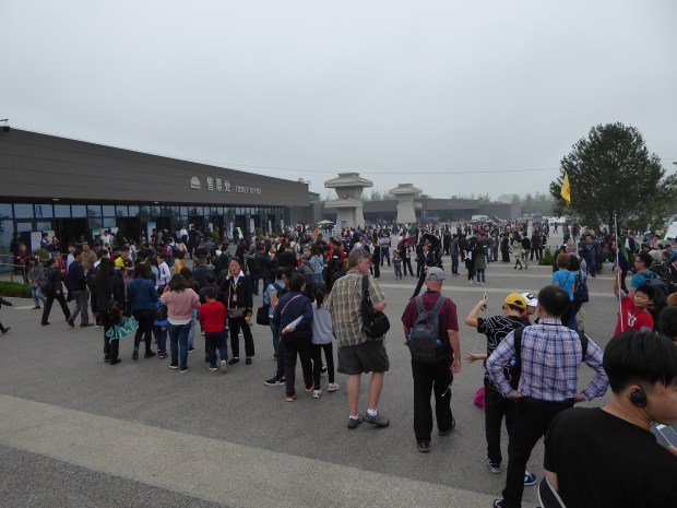
The entrance to the Museum. This was a moderately busy day!

They are called “pits” because they are literally earthen pit shelters where the terra-cotta warriors were buried.

Given the size of the museum complex, our tour guide did the right thing by giving a quick overview and then letting us wander the site on our own for a couple hours. We visited right before the start of the Chinese National Holidays, and I was glad we did. The museum was still busy, but less so than it would be just a few days later, when our guide said the line of traffic to get to the Museum was 10 km long! The Terra Cotta Warriors Museum is probably the #1 attraction in China for locals as well as tourists.
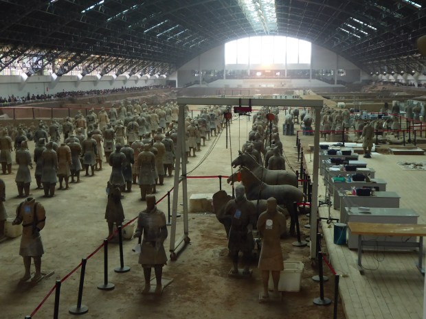
Pit 1

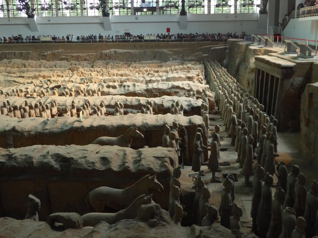
Pit 1 is the largest exhibit, but because of its scale, it’s a little more difficult to get a close observation of the warriors. It contains about 2,000 warriors and horses.

Terra Cotta Warrior Museum, Xi'an, China

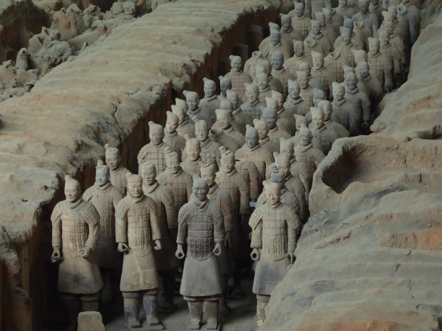
Entrance to Pit 1, the largest of the three Pits.

Most people stop (and clog) at the view by front entrance, but make your way around to the sides (visit both sides) to get other interesting views of the warriors. Be prepared for lots of shoving and pushing as you deal with the mobs. Hang on to your belongings carefully!

Terra Cotta Warriors Museum, Xi'an, China

View of Pit 1 near the entrance. Quite a sight to behold.

Terra Cotta Warriors, Xi'an, China

Another view of the warriors in Pit 1.

Terra Cotta Warriors Museum, Xi'an, China

A side view of Pit 1. The original discovery was made from the digging of a well near the lower right of this photo.

Terra Cotta Warriors Museum, Xi'an, China

A little closer view of the warriors. Their headgear denotes their rank. You can also see a bit of their color here.

Terra Cotta Warriors Museum, Xi'an, China

A closer side view near the front entrance of Pit 1.

Terra Cotta Warriors Museum, Xi'an, China

At the rear of Pit 1, the painstaking restoration work on the terra-cotta figures continues.

Pit 2

Pit 2 is the smallest of the three pits, and excavation work continues here. It was discovered in April 1976, about two years after the discovery of Pit 1.

Terra Cotta Warriors Museum, Xi'an, China

This is a view of Pit 2, the smallest of the three. It consists of more variety of figures than Pit 1, with archers, chariots, calvary and infantry.

Terra Cotta Warriors Museum, Xi'an, China

A closer view of Pit 2.

Pit 3

Pit 3 was the last to be discovered, in June 1976. Extensive damage to the figures in this pit occurred anciently. It was the “command center” for the warriors in the other Pits.

Terra Cotta Warriors Museum, Xi'an, China

A view of the original sloped entrance into Pit 3.

Terra Cotta Warriors Museum, Xi'an, China

View of Pit 3, showing the original earthen coverings and entrances into the Pit.

Terra Cotta Warriors Museum, Xi'an, China

Detail of Pit 3.

Terra Cotta Warriors Museum, Xi'an, China.

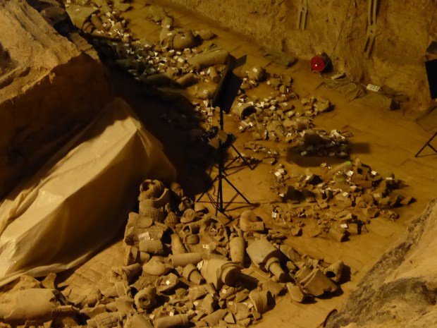
Another detailed view of Pit 3, showing how all destroyed pieces have been labeled.

Bronze Chariots

In a separate building you will find perhaps the most amazing pieces of art at the museum, including two bronze chariot displays from the same era as the terra-cotta warriors.

Terra Cotta Warriors Museum, Xi'an, China

The building where the bronze chariots are located (on the basement level).

These chariots were discovered in 1978, near the emperor’s tomb, and brought to this museum for display. They are amazing in their detailed craftsmanship and have survived well over the centuries. They are made of bronze and painted, with some use of gold and silver too. They are on a 50% scale to full size.

Terra Cotta Warriors Museum, Xi'an, China

One of the bronze chariots.

Terra Cotta Warriors Museum, Xi'an, China

The second bronze chariot. The horses look so lifelike! Note the figure in the cart behind the horses.

Terra Cotta Warriors Museum, Xi'an, China

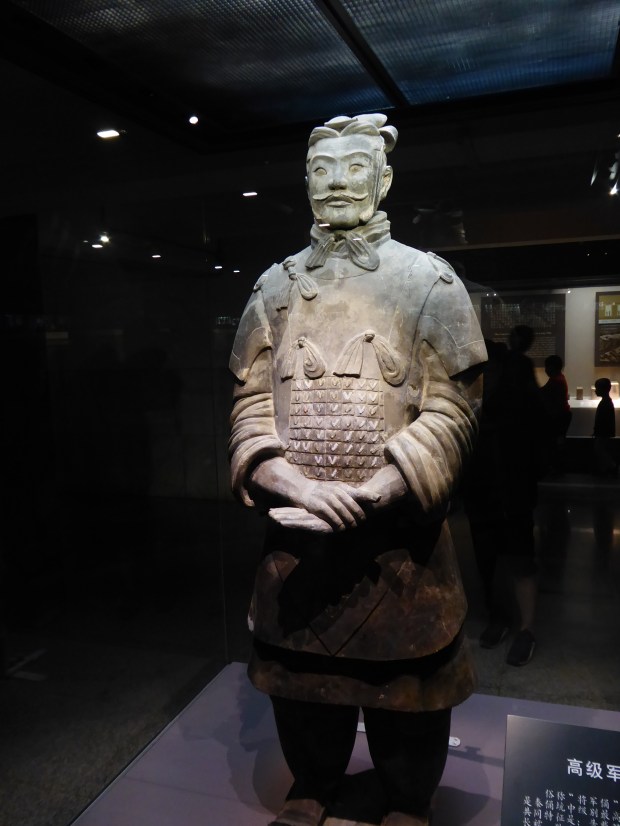
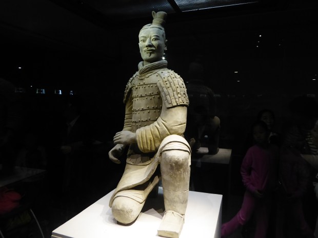
This figure, along with a number of other figures and artifacts are located in the same building as the bronze chariots. This guy is one of seven generals found in the Pits. His armor, headgear and neck bows all point to being a high-ranking officer.

Terra Cotta Warrior Museum, Xi'an, China

I’m not sure of the story behind this boat carved from jade, located in a hallway in the building with the bronze chariots. It has nothing to do (as far as I know) with the Terra Cotta Warriors, but it is an incredible piece of art!

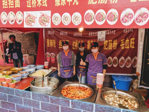
Please note that you enter the huge museum complex in one direction, and on your exit  you go a separate direction through a myriad of food vendors and shops. The displays were quite colorful and entertaining!Xi'an Food3Xi'an Food1Xi'an Food2

Old central Xi’an itself is quite a stunning city, and in my next post I’ll share a few pictures of central part of the city.

Climbing The Great Wall of China — One of the Must-Do’s Near Beijing

The Great Wall without a doubt is the first thing that comes to mind when anyone thinks of China, possibly second only to Panda bears (which we also got to see, more on that in a later post). It’s probably one of those sights that’s on just about everyone’s bucket list. The Great Wall is very impressive, no matter what small portion of it that you are fortunate enough to visit. On this Sinorama tour, we visited the Juyongguan section of the Great Wall, which was a heavily fortified portion to protect a key route through the mountains on the way to Beijing, 31 miles away.

Juyongguan Great Wall, Beijing, China

Juyongguan section of the Great Wall. We climbed up the Wall seen in the hills behind me. It took us about 1.5 hours to climb to the highest point (not quite visible), moving at a fairly quick pace.

Juyongguan Great Wall, Beijing, China

The steepness of the climb can be appreciated in this photo.

I cannot imagine the labor that went in to constructing the wall through the steep, rugged terrain and other natural barriers for thousands of miles. We found enough challenge in just climbing the section that we did, which was steep enough to be hard on the knee joints coming down.

Juyongguan Great Wall, Beijing, China

Taking a short break on the only semi-level section of the Wall in this area.

North of Juyong Pass is Badaling, also considered part of the same pass, and a popular section of the Wall to visit. Years ago I visited the Mutianyu section, which is a bit further from Beijing.

Juyongguan Pass, Great Wall, Beijing, China

Looking towards the Badaling section of the Great Wall (in the far distance) from Juyongguan section, high above the Juyong Pass.

When we think of a wall, usually we think of a pretty straight line with two sides, and the Great Wall, at least in this part of the country, is anything but straight, partially due to the span of multiple construction eras over the centuries and partly due to the rugged landscape.

Juyongguan Great Wall, Beijing, China

Other parts of the Juyongguan section of the Wall can be seen across the valley.

Juyongguan Great Wall, Beijing, China

Lots of stairs–if your job was to patrol this section, you’d be in great shape!

Wall Facts:

The origins of the Wall date back over a millennia ago, although most of the wall we see today was built during the Ming Dynasty, between the mid 1300’s and 1600’s. The Wall runs across norther China and is about 5,500 miles long, of which about 3,800 miles is actual stone wall construction, with the remaining sections being other types of barriers (ditches and natural landscape). Source: Wikipedia

If you visit the Great Wall, be prepared for a LOT of walking, steps, and tourists, at least in the sections of the Wall near Beijing.

Juyongguan Great Wall, Beijing, China

Some of the crowds making their way up as we were coming down. Get there early in the day if possible!

Great Wall Juyongguan Pass16

Get your souvenirs here!

Of course, there are many tourist shops at each location with food, drinks and souvenirs.

Great Wall Juyongguan Pass1

A view of the little village and shops at the base of the Juyongguan section of the Great Wall.


Cruising Ha Long Bay, Vietnam

Our main reason for visiting Hanoi was to have a launch point for a Ha Long Bay cruise. Ha Long Bay is one of the most scenic locations in Vietnam.

On the morning of our cruise departure, we were picked up at our hotel at 8 am by a transportation service that took us to Ha Long City, a 3.5 hour drive east of Hanoi. We enjoyed seeing the countryside and towns along the way. The transportation van was first-class, very comfortable with amenities such as wifi and water.

Ride to Ha Long Bay from Hanoi, Vietnam

Our comfortable ride to Ha Long Bay from Hanoi. The van has wifi!

Ha Long Bay, Vietnam.

Ha Long Bay, with a new ferris wheel being constructed in the background. The goal is to make the town a tourist destination in its own right and not just a transfer point for the cruises.

Ha Long Bay Cruise, Vietnam.

The crowded port with the launches lined up for the waiting junks.

Upon arrival in Ha Long City, we completed some paperwork at the cruise terminal and then took a small launch to our boat (the ‘Prince Junk’). We had purposely chosen a cruise company that offered a smaller boat (see featured image above). There were just four guest cabins, or room for 8 passengers total. After getting settled in our cabins, we were offered a welcome aboard lunch and an orientation to our cruise itinerary. A young man was our cruise director and in addition to him there were 3-4 other crew, plus the captain.

Ha Long Bay Cruise, Vietnam.

Dining area on our ship.

Ha Long Bay Cruise, Vietnam.

Our cabin. Since there were only four rooms, all have large windows with a view.

Ha Long Bay Cruise, Vietnam

The large shower and bathroom in our cabin.

Since it was January, the weather was overcast most of the time, with just a few sprinkles and the air temperature was probably in the upper 60’s F – just a bit warmer than Hanoi. Because of the gray skies, it looked colder than it actually felt. The water was quite warm and perhaps was a bit warmer than the air.

Ha Long Cruise, Indochina Junk, Vietnam

Enjoying the Ha Long Bay view from the lounge deck.

In addition to enjoying the passing scenery that first afternoon, we went on a kayaking adventure with our cruise director, one of two kayaking tours during our cruise.

Kayaking in Ha Long Bay, Vietnam.

Kayaking in Ha Long Bay, with the beautiful rock formations and islands everywhere.

Ha Long Bay Kayaking, Vietnam

Another view of our kayaking – our cruise director is in the first kayak. We each had a watertight container for cameras.

On our 2nd day we went on another kayaking adventure and also to an island with a large cave and lovely beach–this was one of the few places where we ran into other cruise ships.

Ha Long Bay Cruise, Vietnam.

The island with the cave, about halfway up the hill.

Cave, Ha Long Bay Cruise, Vietnam.

Inside the island cave, Ha Long Bay.

Ha Long Bay Cruise, Vietnam.

A view of Ha Long Bay from the cave island.

Also, on the 2nd day we were treated to a beach-side lunch at a quiet cove on another island where we were the only people on the beach.

Ha Long Bay Cruise, Vietnam.

Setting up our lunch on the beach.

Ha Long Bay Cruise, Vietnam.

A panoramic view of the beach where we had lunch. Our boat can be seen in the distance.

On our third day, we went to a floating fishing village in the morning, where the local women rowed small boats for a tour of the village (the men are fishermen) and then a stop at an oyster pearl farm.

Floating village, Ha Long Bay Cruise, Vietnam.

Our tour guides for the floating village. These women work very hard and row a long way!

Ha Long Bay Cruise, Vietnam

A view of part of the floating village.

After our tour of the floating village and pearl farm, we had an early lunch as we cruised back to port for disembarkation at around 12 pm. On the way back to Hanoi, we stopped (along with all other cruise passengers from multiple cruise lines) at Yen Duc village, for a water puppet show, which are unique to north Vietnam. At the show, the hosts provided a wide array of fruits and snacks; the whole event lasts about one hour.

Practical Details

We arranged the cruise several months earlier and were overwhelmed by the choices of cruise companies. We learned that most cruise companies complete the same general itinerary and activities, even though prices for the cruises vary a lot. The junks vary in size from two to 20 cabins.

Ha Long Bay Cruise, Vietnam.

Example of a larger cruise junk in Ha Long Bay.

We choose a more expensive, small cruise junk option, so that we could have a smaller number of passengers and (likely) increase the quality of the food (the food is well prepared and presented, the cuisine is mainly seafood with a few other meat and chicken dishes too. Bring some snacks/fruits along if you wish to supplement what is provided). Given the immensity of the bay, we were largely out of sight of other cruise vessels. Most cruises are one or two nights. We opted for the two night cruise. Tips are provided directly to the captain (which he distributes to the crew) and cruise director at the end of the cruise, so be sure to bring cash. I don’t recall the specific amounts, but the equivalent of $10-15 per person (guest) should be sufficient.

The Wonders of Angkor Archeological Park, Cambodia – Day 1

After getting settled in Siem Reap our first night, we were ready the next morning to hit the ground running and see the magnificent temples of Angkor Archeological Park. It is helpful to have a good map of the main temples when reviewing the post below and preparing for a visit. I thought the map referenced here was excellent. Listed below are the sights we visited on the first day:

The Royal City of Angkor Thom (Big Angkor).

Angkor Thom covers a large area (3 km2) and contains many interesting structures and is second only to Angkor Wat in terms of priority to visit. It is just north of Angkor Wat and as I suggest below, bypass Angkor Wat (for now) and head directly to Angkor Thom. Angkor Thom was a walled and moated royal city, the last capital of the Angkor Empire. Most of the buildings date from the late 12th century to the early 13th century. You can spend much of the day just exploring the structures here:

Bayon. One of the most famous temples in Angkor Thom. Its configuration represents a stone mountain and it served as the state temple of King Jayavarman VII.

bayon-58

A view of Bayon Temple.

bayon68

One of my favorite views of the towers at Bayon temple.

bayon-34

A passageway at Bayon.

There are 37 existing towers (out of 49 originally), most of which are carved with 4 faces, or in some cases 2 or 3 faces.

bayon-20

A closeup of the faces at Bayon.

It underwent several renovations under later kings.

Terrace of the Elephants and Terrace of the Leper King. The Elephant Terrace is 300 meters long and dates from the 12th century. It derives its name from the carved elephants on part of the walls. It fronts the Baphoun Temple and provides the backdrop for an impressive Royal City thoroughfare.

terrace-of-the-elephants-4

The Terrace of the Elephants.

terrace-of-the-elephants-1

The elephants from which the terrace derives its name.

The Terrace of the Leper King is just north of the Terrace of the Elephants and contains intricate carvings, many found on a hidden double wall that was just excavated in the late 1990’s.

terrace-of-the-leper-king-5

A close-up of the double wall at the Terrace of the Leper King.

terrace-of-the-leper-king-6

Close up of a carving at the Terrace of the Leper King.

Just east of these terraces are other small towers lined up in a row whose purpose is not clear. To the west of these terraces are the following temples:

Baphuon. Another state temple, and an earlier (mid 11th century) construction than Bayon. This pyramid temple underwent major restoration and rebuilding over almost a 40 year period.

baphuon-11

A view of Baphuon and the causeway leading up to the temple.

The restoration was interrupted during the Khmer Rouge dictatorship years in the 1970’s, and records regarding the restoration were unfortunately lost, leaving a huge pile of blocks!

baphuon30

A view from the top of Baphuon.

Phimeanakas. Close to Baphuon, this pyramid temple dates to the mid 10th century, and sits on the site of the Royal Palace, which no longer stands. However, there are enough remnants including walls, gates and pools to give an idea of the grandeur of the palace grounds.

phimeanakas-2

Phimeanakas Temple


baphuon38

A view of a gate, wall and pool on the Royal Palace grounds near Phimeanakas.

Outside of Angkor Thom.

Just to the east of Angkor Thom are two small but well restored temples, both similar in style to Angkor Wat. Both temples have Hindu and Buddhist themes in their carvings. They also look very similar to each other, but were actually built in different periods. The best news is that they don’t receive a lot of visitors, so they make a peaceful and pleasant stop and a good place to get photos without crowds.

Thommanom. This is the older temple of the two. Built in the 11th century.

thommanom11

Thommanom Temple

Chau Say Thevoda (or Chao Say Tevoda). Directly opposite of Thommanom on the south side of the road leading out of Angkor Thom. From the 12th century.

chau-say-thevoda-1

Chau Say Thevoda Temple.

Ta Keo. Ta Keo is just a bit further east of the two temples above, and different in style from the examples above. Ta Keo was constructed out of sandstone and very plain, without much decoration. It is an older temple, originating in the late 10th century.

ta-keo-8

Ta Keo Temple–the red sandstone is apparent.

Ta Prohm. Perhaps the most romantic and mysterious temple in the Angkor area, and definitely one of the most famous, having been a filming location for the movie Tomb Raider starring Angelina Jolie.

ta-prohm-12

Entrance to Ta Prohm.

ta-prohm-53

The famous “Tomb Raider” door.

ta-prohm

A panorama of the interior courtyard of Ta Prohm.

This temple has purposely been left more or less in its natural ruined state to show what the temples looked like during their rediscovery in the 19th century.

ta-prohm85

Another personal favorite view of Ta Prohm.

ta-prohm-32

One more view of Ta Prohm. Almost every inch of this temple is a postcard image.

Ta Prohm was built between the mid 12th century and early 13th century. It was a Buddhist monastery, and a very wealthy one at that – controlling 3000 villages and known for its stores of jewelry and gold. Definitely a must-do on any itinerary. Hint: Ta Som, a temple we visited on our 2nd day (my next post), was almost as stunning and far less busy.

Angkor Wat. The granddaddy of them all and the world’s largest religious monument. We saved a visit to this temple until the afternoon and we were glad we did for two reasons: a) Fewer tourists. Since this is the first temple one comes to after the ticket entrance, most tours stop here first. We came back in the afternoon, and while there were still some tourists, there were no where near the crowds we saw in the morning. b) The view. The typical morning haze and clouds in this region dissipate by the afternoon, and we were left with a glorious temple bathed in perfectly positioned afternoon sunshine.

angkor-wat-24

A perfectly blue sky in the afternoon at Angkor Wat.

angkor-wat64

A panorama of Angkor Wat.

Angkor Wat was a temple-mountain dedicated to the Hindu god, Vishnu. It dates from about mid 12th century. The towers are 65 meters high and it has an unusual western orientation (rather than eastern, as most other temples in Angkor).

angkor-wat-39

One of the courtyard and towers of Angkor Wat.

angkor-wat-49

A worship service at Angkor Wat.

Its large moat, enclosures and towers represent the Hindu universe. One could spend days exploring all the carvings and symbolism of this magnificent temple.

angkor-wat67

A view from the southeast corner of the Angkor Wat temple – almost no one goes out here.

Phnom Bakheng. The last temple we visited on our first day is pretty close to Angkor Wat, and required a 20 minute hike up the hill on which it is located. The temple itself is difficult to get a picture of, due to its orientation on the hill–it’s hard to step back and get a good view, and we found it a bit less impressive than the others.

phnom-bakheng-2

Phnom Bakheng temple.

phnom-bakheng-7

A view of Angkor Wat from the Phnom Bakheng temple.

The main reason for climbing the hill (and then climbing up the temple) is for the views overlooking the whole Angkor area and especially Angkor Wat. Many people (like us) make the hike up in the afternoon or right before sunset for the views. This temple is the oldest at Angkor, dating from the late 9th century and was the first state temple as Angkor became the capital city of the Khmer Empire. This temple is also undergoing restoration work.

More to come in my next post!


Highlights of Thailand, Part 4: Railay Beach – One of the Most Beautiful Places on Earth

I know there are a lot of amazing sights in this world, and I’ve had the privilege of seeing many of them. One place that is now definitely on my list of “most amazing sights” is Railay peninsula, located on the eastern shore of the Andaman Sea, about 80 kilometers straight east of Phuket. Phuket is probably the most well-known resort and beach location in Thailand, but we decided to go to a bit quieter area. My nephew and his wife had visited here about a year earlier, and based on their recommendation we decided to make the Railay beaches home for a few days.

east-railay-beach-environs10

My wife and son upon our arrival at Railay peninsula. Typical long boat transportation to/from the peninsula is right behind them.

What a good choice! The peninsula (with its beautiful beaches) is isolated from the mainland due to rugged terrain and high cliffs and is accessible only by boat.

railay-viewpoint-1

A view overlooking Railay peninsula. West Railay Beach is in the distance and East Railay Beach is in the foreground. (Phra Nang Beach, shown below, is to the left and not visible). This view required a very steep, short hike.

There are several hotels on both West and East Railay beach, and some guest houses hidden up in the hills. We decided to stay in a pretty nice resort on West Railay Beach, and we were glad we did.

railay-sand-and-sea-resort-room

Our bungalow on West Railay Beach.

railay-beach-sand-and-sea-resort-2

Our hotel’s pool, overlooking West Railay Beach.

railay-beach3

There are lots of restaurants near the beaches.

The setting was gorgeous – a wide crescent shaped sandy beach with high cliffs at either end. Walking paths take you across the peninsula and up into the cliffs.

railay-beach2

An early morning view of one end of West Railay Beach.

railay-beach1

An early morning view of the other end of West Railay Beach.

There are lots of things to do here. You can spend your whole time blissfully on the Railay beaches, at your hotel pool, or hiking into the nearby cliffs and caves.

phra-nang-railay-beach-environs-25

A view of Phra Nang Beach, on the southern end of Railay peninsula, from some overhanging cliffs – a surreal spot.

phra-nang-beach82

Sunset at Phra Nang Beach

west-railay-beach-environs17

Near West Railay Beach there is a more rustic spot with backpackers.

Additionally day trips via boat take you to islands around the area. One day tour (on a speed boat) took us to a few other islands and included time for lounging and snorkeling. Hong Island was a favorite stop, with another stunning beach, and the island is a national park.

railay-beach-hong-island-tour-21

The beach on Hong Island. A photo does not do justice to the beauty of this spot.

railay-beach-hong-island-tour-tsunami-damage-19

A remnant on Hong Island of the huge Tsunami that devastated much of the region on December 26th, 2004.

hong-island

A stop for snorkeling on our speed boat day tour.

railay-beach-hong-island-tour-8

Another stop on our speed boat tour, Koh Phak Bia island.

On another day we took a ferry to Phi Phi island. It is a pretty large ferry (foot traffic only), and is slow.

phi-phi-island-1

A beach on Phi Phi island.

Phi Phi Island is a tourist hotspot because it is close to Maya Beach, the famed filming location for the 2000 movie The Beach with Leonardo DiCaprio.

Railay Beach was our last stop in Thailand. On our final morning we took a long boat back to Ao Nammao pier, then a taxi to the Krabi airport (which we had prearranged) and then a flight from Krabi to Bangkok and another flight to Phnom Penh, Cambodia (our next destination).

If you get the opportunity, do NOT miss this part of Thailand.

Getting There:

From Chiang Mai, we took a direct flight to Krabi, the gateway to many beach destinations. From Krabi, we took a taxi to Ao Nammao pier, a tiny port where you then take a long boat with your luggage (about a 15-minute ride) to East Railay Beach. It is then a short walk across the peninsula to West Railay Beach. Alternatively, you can take a taxi from the Krabi airport to Ao Nang, and get a long boat from there to West Railay. Ao Nang is a little busier port.

It is wise to prearrange your taxi back to Krabi airport, which can be done at Ao Nammao pier upon arrival from the aiport. Also note that long boats require a minimum number of passengers to depart from Railay Beach or you will have to pay the equivalent fare of a full boat. Allow yourself plenty of time for the travel logistics to catch your flight.

The World Heritage Sites of Ajanta and Ellora Caves – Part I

Although we didn’t know it at the time, we saved some of the best sights in India for the last part of our trip. From the desert city of Jaisalmer we drove back to Jodhpur and then flew to Aurangabad (via an overnight connection in Mumbai). Aurangabad is about 217 miles northeast of Mumbai.

Aurangabad is the gateway to the world-renowned Ajanta and Ellora Caves – both of which are incredible ancient temple complexes.

A road scene on our way to Ajanta.

A road scene on our way to Ajanta.

The two temple complexes are very different. The Ajanta Caves are largely carved INTO rock, the Ellora Temples are carved OUT OF rock.

A view of the path to the Ajanta Caves - you can see how they are carved into the rock face. Some entrances are more elaborately carved than others.

A view of the path to the Ajanta Caves – you can see how they are carved into the rock face. Some entrances are more elaborately carved than others.

This post will focus on the Ajanta Caves, which were part of a Buddhist monastery complex. The oldest caves date back to the 2nd century BC, and additional ones continued to be hewn out of the rock until the 6th century AD.

My mother-in-law getting a ride from porters up to the caves.

My mother-in-law getting a ride from porters up to the caves.

When the temples at Ellora were emerging from the rock, Ajanta began to decline and was eventually forgotten until the 1800’s when it was discovered by chance by a British hunting party. The paintings (actually temperas, which use pigment with a binding substance like egg yolks) are amazing, but are mostly kept in very low illumination to keep them from fading and being further destroyed.

An example of the cave paintings.

An example of the cave paintings.

There are about 30 caves, most of which are accessible, they are numbered and are more or less in order as you visit them. We visited about 10 of the caves. There are plaques (in English) outside each cave that provide some information, and then you are free to wander inside.

An example of the plaques outside each cave.

An example of the plaques outside each cave.

Interior view of Cave #1 with its tempera decorations. Amazing to think that these paintings are almost 2,000 years old.

Interior view of Cave #1 with its tempera decorations. Amazing to think that these paintings are almost 2,000 years old.

Interior view of Cave #2.

Interior view of Cave #2.

A large Buddha in Cave #6.

A large Buddha in Cave #6.

Exterior view of Cave #17.

Exterior view of Cave #17.

The 'Sleeping Buddha' in Cave #26.

The ‘Sleeping Buddha’ in Cave #26.

The incredible interior of Cave #26. Remember, all this was carved out of solid rock.

The incredible interior of Cave #26. Remember, all this was carved out of solid rock.

One other view in Cave #26.

One other view in Cave #26.

Cave #24 - unfinished, giving a feel for the work required to carve just one of these beautiful temples.

Cave #24 – unfinished, giving a feel for the work required to carve just one of these beautiful temples.

In some caves there are guards present, to ward off flash photographs and to ensure the safety of the old paintings. The caves are in a horseshoe shape around a bend in a river. To get an overlook of the area, hike up to the viewing point at the bend of the river.

A view of some of the Ajanta caves from the hill above the river. Similar to the view the British hunting party would have seen.

A view of some of the Ajanta caves from the hill above the river. Similar to the view the British hunting party would have seen.

You’ll also see some waterfalls and lakes in the distance. What a stunning setting for the Ajanta Caves!

Practical Information: We hired a taxi to take us to the Ajanta Caves for the day. The driver waited patiently for us and returned us to our hotel that afternoon. The cost was about $20 US. The Ajanta Caves are about 105 km (60 miles) north of Aurangabad and the Ellora Caves are only about 30 km (18 miles) north of Aurangabad. Both sights could probably be visited in one very long day; however, to allow sufficient time, we visited them separately on two consecutive days. We were able to combine a visit Daulatabad Fortress the same day as the Ellora Caves, which was well worth the stop (I will cover both of these locations in my next post).

Jodhpur, India – Home of the Colossal Mehrangarh Fort

From Udaipur (via Ranakpur and Kumbahlgarh) we visited the large Rajasthan city of Jodhpur, about 198 miles (319 km) distant. For a map of locations visited in India, click here.

The huge Mehrangarh Fort dominates the landscape for many miles.

The huge Mehrangarh Fort dominates the landscape for many miles.

One of the main sites in Jodhpur is the magnificent Mehrangarh Fort, sitting on a prominent hill dominating the sprawling city which has seen tremendous growth in the last decade. The fort was built around 1460. The thick, high walls (over 100 feet) of the fort make it an imposing structure and it must have been a very intimidating sight for potential invading armies 500 years ago. There are miles of old walls extending around the area in every direction.

One of the gates leading into the fortress.

One of the gates leading into the fortress.

Cannonball pockmarks from the 1800's can be seen on this bastion.

Cannonball pockmarks from the 1800’s can be seen on this bastion.

The fort dates from the 16th century, and contains palace rooms with numerous intricate lattice stone carvings; ladies of the court could view the activities of the fort’s daily life without being seen.

The intricate lattice stone work can be seen in this photo.

The intricate lattice stone work can be seen in this photo.

The fort is now a museum containing various displays in the rooms (such as a collection of highly decorated palanquins and paintings as well as a collection of arms) and period furniture.

One of the palanquins on display.

One of the palanquins on display.

Display of daggers and other formidable weapons.

Display of daggers and other formidable weapons.

Interior of the Phool Mahal at Mehrangarh fort.

Interior of the Phool Mahal at Mehrangarh fort.

North side of the fortress, with several gates leading up into the main area.

North side of the fortress, with several gates leading up into the main area.

An audio guide provides a good overview of the fort. On the north side, just outside the main gate are some beautiful gardens that are worth a vist. Jodhpur is known as the blue city. The city’s founder decreed that the homes surrounding the fortress be painted blue, but no one seems to know why blue was chosen. A number of homes near the fort still retain the blue hue.

The blue buildings near the fort's north side.

The blue buildings near the fort’s north side.

Other Sights in Jodhpur

Jaswant Thada. Close to Mehrangarh fort is the beautiful Jaswant Thada, a white marble memorial to Maharaja Jaswant Singh II. There are nice views of the fort from this location. It was built in 1899.

A view of the Jaswant Thada.

A view of the Jaswant Thada.

Mandore. This area was the original capital of the local Marwar Kingdom until the 1400’s. This small city contains beautiful temples, tombs, and gardens. It is an area that does not see a lot of tourists, but we found it quite fascinating.

A view of Mandore with the shrines, temples and gardens.

A view of Mandore with the shrines, temples and gardens.

Inside one of Mandore's temples.

Inside one of Mandore’s temples.

One of the Hindu shrines in Mandore.

One of the Hindu shrines in Mandore.

Clock Tower. This is a landmark in the older part of the city. During the day there are numerous market stalls selling all kinds of food and other goods.

A view of the Clock Tower at night.

A view of the Clock Tower at night.

Markets near the Clock Tower.

Markets near the Clock Tower.

Our hotel in Jodhpur, the Pal Haveli Inn. It has a very peaceful and quiet courtyard inside, a respite from the chaos of the city.

Our hotel in Jodhpur, the Pal Haveli Inn. It has a very peaceful and quiet courtyard inside, a respite from the chaos of the city.

Our hotel (above) was in an excellent location, in the heart of the old city next to the Clock Tower and square. From the peaceful courtyard of our hotel you are immediately plunged into this market area and feel the ‘real’ India. The hotel had a rooftop restaurant that overlooked the fort for a lovely night view.

A view of Mehrangarh Fort from our hotel rooftop restaurant.

A view of Mehrangarh Fort from our hotel rooftop restaurant.

The Gate to Hell: The Ancient City of Hierapolis and Travertine Terrace Pools of Pamukkale

The theater at Hierapolis could seat 20,000.

The theater at Hierapolis could seat 20,000.

Put these sights on your “don’t miss” list in Turkey. The combination of the ruins of Hierapolis and the terraces of Pamukkale, famous for the brilliant white travertine pools make this an unforgettable destination. Hierapolis was founded in 190 BC and became part of the Roman Empire in 133 BC. Later on it was part of the Byzantine Empire and eventually faded into obscurity in the 6th century. Among other things, it was a spa town known for its thermal baths, and the warm water still runs here.

The northern gate to Hierapolis.

The northern gate to Hierapolis.

An elevated tomb at the extensive necropolis of Hierapolis.

An elevated tomb at the extensive necropolis of Hierapolis.

The Nymphaeum - in ancient times there would have been fountains everywhere on this structure. This is near Pluto's Gate.

The Nymphaeum – in ancient times there would have been fountains everywhere on this structure. This is near Pluto’s Gate.

The “Gate to Hell” reference applies to a spot on the site known as Pluto’s Gate (Pluto was a deity of the underworld), and the lethal vapors bubbling up from the waters running underneath the city were used to sacrifice animals as part of sacred pagan rites, with hallucinating priests performing the ceremonies (not unlike Delphi in Greece). This spot was undergoing excavation during our visit in 2012, and a recent article confirms this historical reference. Also, it’s believed that the apostle Philip met his death here (by stoning and crucifixion) in AD 80.

Frontinus Street - the main thoroughfare in Hierapolis.

Frontinus Street – a main thoroughfare in Hierapolis.

Swim in the warm waters among the ruins.

Swim in the warm waters among the ruins.

You can swim among the ruins, and this water is the basis for the white travertine terraces, which are just at the edge of the ancient city on a ridge overlooking the town. Pamukkale means “cotton castle” which is an apt description as you gaze at the terraces from below. The travertine terraces are formed from white limestone residue as the carbon dioxide escapes the water.

Where the ruins and travertine meet - this tomb is half-buried by the travertine residue.

Where the ruins and travertine meet – this tomb is half-buried by the travertine residue.

Some of the travertine terraces at Pamukkale.

Some of the travertine terraces at Pamukkale.

The setting sun reflecting on the travertine pools.

The setting sun reflecting on the travertine pools.

A few practical tips:

  • Visit the site in the afternoon (there is a parking fee of 5 TL and an entry fee of 20 TL per person (1.8 TL per USD) for both the ruins and travertine pools). By late afternoon the mobs and tour buses are leaving. We arrived about 3:30 pm (in September) and this was perfect timing to see everything and to watch the setting sun reflecting in the travertine pools.
  • Keep in mind the ruins of Hierapolis are significant and spread out. Depending on your interest in ruins, you can easily spend 2-3 hours exploring.
  • An ‘artificial’ section of the travertine pools are open for visitors to walk on.  Plan to take your shoes off and roll up your pants. The water is warm and the surface is a bit slippery.

    Walking and wading in the pools.

    Walking and wading in the pools.

  • The thermal pool with the marble column ruins is expensive and requires a separate entry fee which is about $30 US per person. We skipped the swimming but enjoyed the ambience. There is a snack shop right there and you can enjoy the picturesque setting for the price of a soft drink.
  • We stayed at the Hotel Venus in Pamukkale. It was an excellent small hotel, with a pool, nice large rooms, a very good restaurant and great breakfast buffet. It is just 5 minutes or so by car to the ruins. The room was €35 per night.

    Another excellent Turkish meal at the Hotel Venus, where we stayed.

    Another excellent Turkish meal at the Hotel Venus, where we stayed.

  • Pamukkale (which is about 15 km from the large city of Denizli), is a quiet little village and a great place to stay. The drive from Fethiye (on the south coast) took approximately 4 hours (about 200 km, on country roads).

Also fairly close to these sights are the ruins of Aphrodisias, which I will cover in a separate post.

References: DK Eyewitness Travel Turkey, 2008. Lonely Planet – Turkey, 2010.

Cappadocia from the Air

I’ve heard people say “we’ve been to Turkey” and when asked about where they’ve been, they may say Istanbul and perhaps Ephesus. My reaction is to think “then you really haven’t seen Turkey.” The Cappadocia region, located in central Turkey, is unique in geography and history. With the spectacular rock pillar formations, and thousands of troglodyte dwellings and churches carved into the soft stone, this area feels like it belongs on another planet, and hence why it’s been an inspiration for a number of movies (see my post on Selime Cathedral). The odd landscape is due to volcanic activity millions of years ago in the form of ash and lava, some of which is very hard and some of which is very soft (called tuff) and easily eroded or carved out. A hot air balloon ride is a great way to get a feel for the topography of the area and was one of our most memorable activities on a two-week trip in Turkey.

The surreal town of Goreme.

We stayed right in Göreme, a fairy-tale looking town with gnome-like homes in the heart of the Cappadocia region. The town of Göreme is ground central for the Cappadocia hot air balloon industry.  Having flown all the way from the U.S. to Kayseri (about 80 km from Göreme, one of two airports serving the region) the day before, and after finally getting to bed at 1 am, we arose about 3 hours later to in order catch our 5 am shuttle van to the balloon center. Every morning almost year round about 100 balloons rise above the landscape to give up to 2,000 tourists a one-of-a-kind view. Some balloons hold as many as 20-25 people, ours held eight, and since there were six of us, it was almost a private tour.  Our grogginess soon gave way to excitement as we neared the balloon launch area—seeing the balloons being fired up against the pre-dawn clear sky was exhilarating.

Here is a photo timeline of our balloon ride:

The balloons filling with hot air against the pre-dawn sky.

H

Lifting off…

More balloons take to the air.

Flying over the town of Cavusin, with a myriad of stone-carved houses.

A little groggy, but enjoying the view.

Looking north towards Uchisar castle (the rock formation) from high over Goreme.

From about 1,500 ft up–the town of Goreme and the eroded tuff landscape.

The fairy chimneys of Cappadocia–we floated right through the valley.

The scoop on the balloon rides:

We made our reservations (Ürgüp Balloons) via our hotel in Göreme, prior to our arrival in Turkey. The shuttle van picks you up at about 5 am from your hotel, and takes you to the balloon center, where you’re offered some breads, biscuits, coffee and juice. At about 5:45 am you then head to the balloon launch field, and based on your ID sticker you’re directed to your balloon and crew. At your balloon, you are given a short safety demonstration on how to position yourself for landing and by about 6 am, you’re going aloft. Bring a light jacket, even in the summer. For most of the ride, the balloon is only perhaps 100 feet off the ground, and sometimes less, giving you a close look at the rock formations and dwellings. At one point we went up to about 1,500 feet above the landscape. This ride was a great thing to do on our first day; it gave us a visual overview of the area.

The ride is not cheap, and costs about the same as a ride in the U.S: €130 per person (about $100 US), and this was about €15 more than if we had been in a group of 20. At the end of our ride (60-75 minutes) we made a landing on a flat hill top, and then were treated to champagne and juice to celebrate a safe trip!

At the end of our ride–a safe landing!

Celebrating at the end of our early morning adventure.