Greece

Monastery of St. Nicholas, Meteora, Greece.

Meteora – Nearly out of this World

Roussanou Monastery, Meteora, Greece.

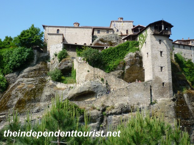
Monastery of Roussanou (aka Ayia Barabara–a Nunnery) in Meteora.

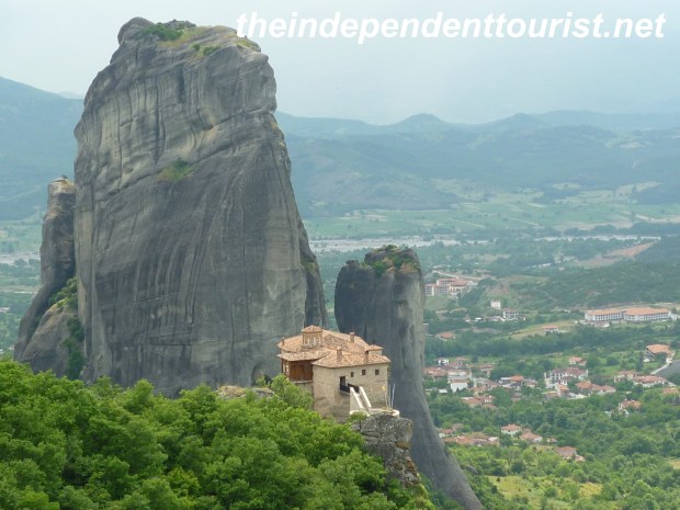
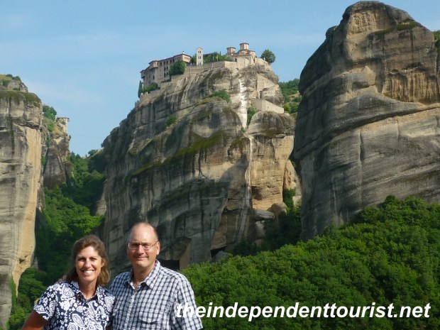
One of the great sights in the world, let alone Greece, is Meteora. The combination of stunning natural scenery—huge sandstone rock pinnacles–with medieval 14th century monasteries sitting on top of them is a sight I will not forget. About 5 hours by car northwest of Athens, Meteora (which is close to the fairly large town of Kalambaka) is well worth the drive, which we did by way of Delphi (about 3.5 hours from Delphi to Meteora). The word Meteora comes from a Greek word which means “to hang in midair” and after seeing this area, it’s easy to see how the word aptly describes the monasteries built on the tops and down the sides of the rocks.

Holy Monastery of Varlaam, Meteora, Greece.

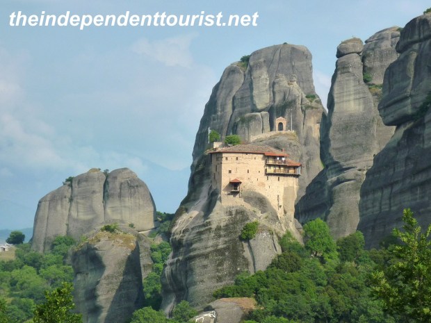
Holy Monastery of Varlaam (top-center).

Although the drive from Delphi to Meteora is initially through steep valleys and mountain passes, the mountains give way to a wide fertile valley (the Thessalian plain), which made me wonder what the setting would really be like. As we got close to Kalambaka, the rock pinnacles suddenly appeared in front of us as the gateway to Meteora and the mountains in the area.

Meteora Map, Greece.

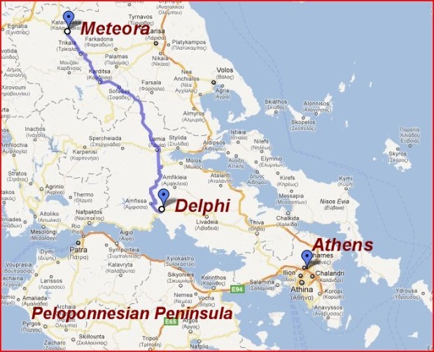
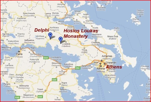
Meteora is about 5 hours northwest of Athens and about 3 hours north of Delphi.

We visited in early June 2011 and the green vegetation of the valley floor and hills is a picturesque contrast with the dark sandstone rock pinnacles. The monasteries of Meteora blend with the surroundings and give the setting a surreal feeling.

Varlaam Monastery, Meteora, Greece.

Holy Monastery of Varlaam (looks like it could slide right off the rock!).

Monastery of St. Nicholas, Meteora, Greece.

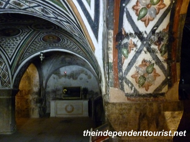
Holy Monastery of St. Nicholas Anapafsas, the smallest monastery at Meteora,chapel built in 1388, 16th century frescoes

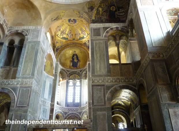
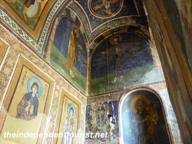
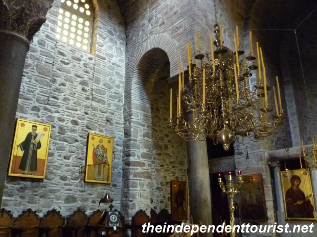
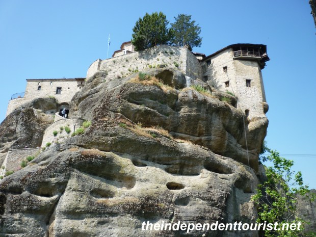
The rock pinnacles served as a retreat for religious orders during the Byzantine–Turkish wars of the 14thcentury. Within 200 years, 13 monasteries were established. Ruins of monasteries no longer standing can still be seen on some rock cliffs. The first monastery, Great Meteoron, was founded by St. Athanasios in the mid 1300’s; he also gave the name to the area, Meteora. Many of the monasteries have highly decorated chapels with frescoes of various biblical scenes. The taking of pictures is not officially allowed in the chapels, but I did take some non-flash video inside several of the chapels.

Great Meteron Monastery Interior, Meteora, Greece.

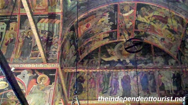
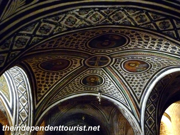
Frescoes in Great Meteron Monastery chapel.

Great Meteron Monastery, Meteora, Greece.

View of the stairway and windlass tower of Great Meteron.

Kitchen, Great Meteron, Meteora, Greece.

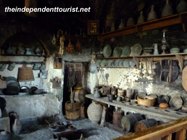
The kitchen at Great Meteron (dated around 1557).

Great Meteron Ossuary, Meteora, Greece.

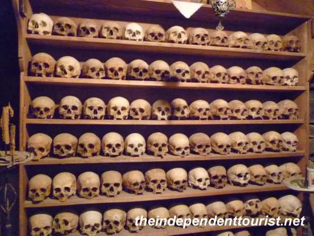
The Ossuary at Great Meteron.

Great Meteron Monastery Courtyard, Meteora, Greece.

Neatly manicured courtyard at Grand Meteron Monastery.

Storage room, Great Meteron Monastery, Meteora, Greece.

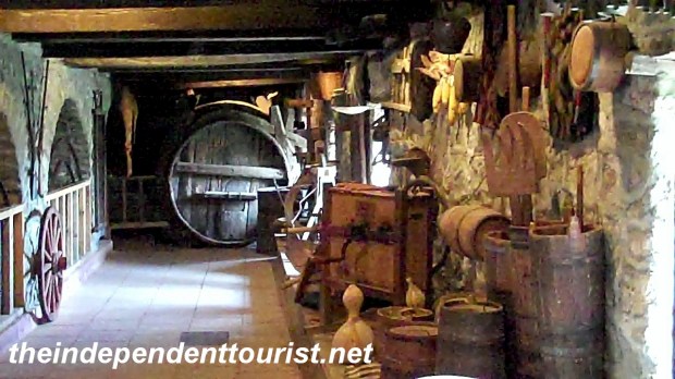
Tools storage room at Great Meteron Monastery.

Other features vary depending on the monastery—some have beautiful gardens and views. The largest, Great Meteoron, is almost a museum–with an old (dates from 1557) kitchen, Ossuary, and equipment storage rooms on display. The monasteries are in close proximity, but since some walking or hiking is required, at least 60-90 minutes per monastery is a good estimate.

Practical Information:

All monasteries can be visited in one full day, especially if you are staying in Kastraki or Kalambaka. We recommend Kastraki as a base, since it is so close to Meteora. A car is the easiest way to visit the monasteries, and allows you the freedom to arrive and leave at your leisure. There are also footpaths among the ravines, connecting the towns with the monasteries and if you have the time, they would be a lovely way to see the area.

Holy Monastery of St. Stephen, Meteora, Greece.

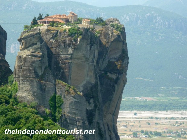
Holy Monastery of St. Stephen is the most easily accessible.

Each monastery has a €2 entry fee per person.  Be prepared for stairs, and lots of them. One of the monasteries, St. Stephen’s, (actually a convent) is easily accessible from the car park and does not require stair climbing. Others require a hike down and up steep stairways. In the old days windlasses with nets or baskets were the only way up into the monasteries–ensuring safety during times of war.

St. Stephens Monastery, Meteora, Greece.

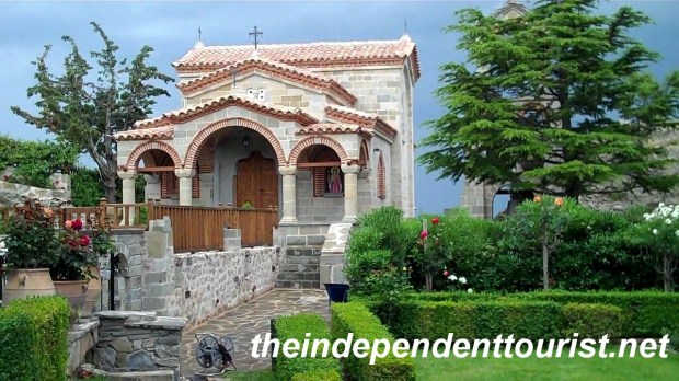
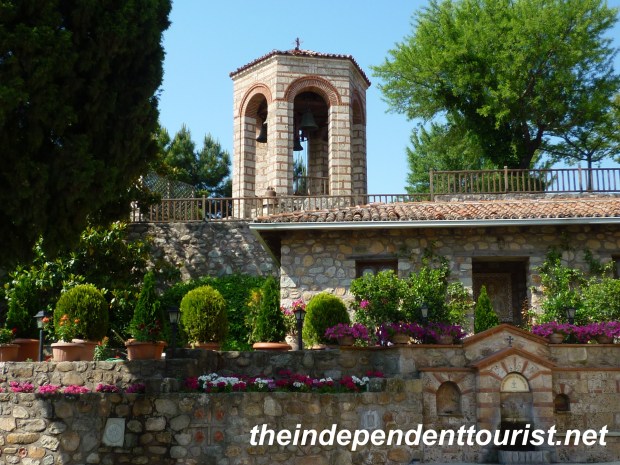
Small chapel at St. Stephen’s.

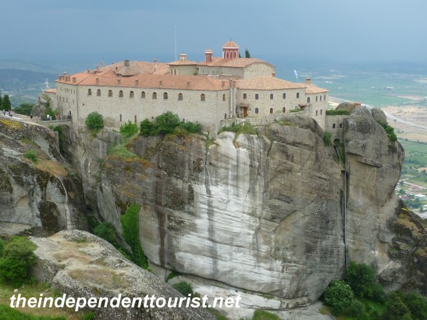
The busiest monasteries are Great Meteron (aka Moni Megalo Meteoro or Monastery of the Transfiguration), St. Stephen’s, and to a lesser extent Varlaam. Be prepared for tour buses at Great Meteron.  We had the Holy Trinity and St. Anapafsas monasteries to ourselves.

Holy Trinity Monastery, Meteora, Greece.

Holy Trinity Monastery of James Bond fame (see separate post).

As usual, getting to the monasteries earlier (or later) in the day will help in avoiding the crowds.  Check opening days and hours carefully. We visited on a Saturday and all of them were open, but some are closed other days of the week.  Most open at 9 am. There are small parking lots at each of the stairway trails to the monasteries.

Holy Monastery of St. Stephen_Meteora (4)

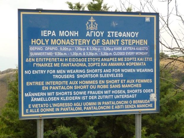
Sign warning of dress standards at St. Stephen’s monastery.

The monasteries are picky about dress.  They require women to wear dresses or skirts, although they have free wrap-around skirts available at the entrances. For men, shorts are not officially allowed, but we did see men in shorts at several of the monasteries. To avoid any hassle, men should wear long pants. Also, men, don’t try to wear the skirt wraps—the monks don’t appreciate this!

Holy Monastery of St. Stephen_Meteora (2)

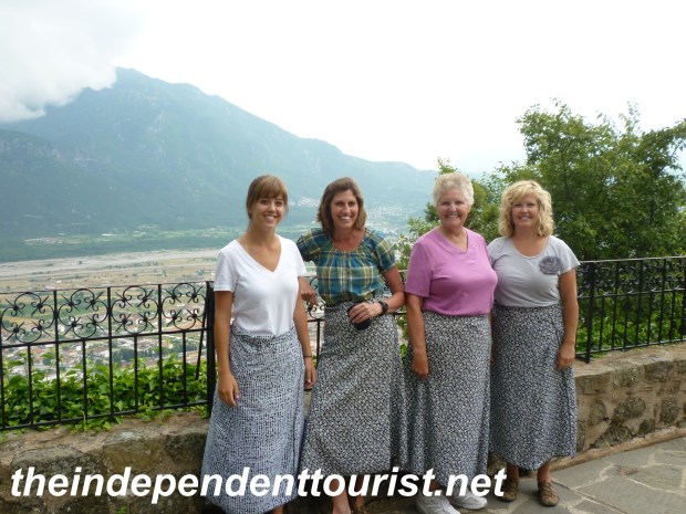
Wearing skirts at St. Stephen’s.

We stayed in Kastraki, a small village just a couple of kilometers up the road from Kalambaka, it’s nestled among the rock pinnacles, with a great view. Our hotel, Doupiani House, was in a perfect location with many rooms having a balcony view of the rocks of Meteora.

Doupiani House hotel, Kastraki, Meteora, Greece.

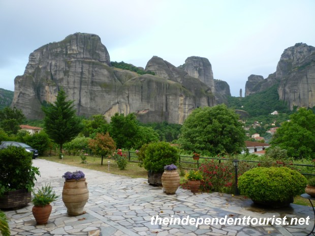
View of Meteora from Doupiani House hotel, Kastraki.

References: Frommer’s Guide to Greece, Lonely Planet Greece Guidebook and information sign posts at Meteora.

Temple of Poseidon, Greece.

Day Trips from Athens – Temple of Poseidon

Temple of Poseidon, Greece Map.

The Temple of Poseidon is about an hour south of Athens by car.

South of Athens, at the end of a peninsula, lies the town of Sounion, and the majestic ruins of the Temple of Poseidon on a cliff overlooking the sea.  It’s about a one hour drive from the city and about a half hour from the Athens airport.

The west coast of the peninsula is a long string of beautiful coves and beaches. The closer to Athens one gets the busier the beach, especially on weekends. We were there on a Sunday in June, and the northern beaches were packed, but those nearer to Sounion were pretty quiet.

Sounion, Greece

The bay and beach of Sounion

Beach, Sounion, Greece

One of the many coves and beaches near Sounion

The temple was built between 444 and 400 BC.  It is quite well-preserved with 15 original columns still standing. Anciently, to sailors returning to Athens, the Temple of Poseidon was a landmark that indicated they were almost home.

Temple of Poseidon, Greece

Temple of Poseidon

Temple of Poseidon, Greece.

View of Temple of Poseidon from the stoa.

Temple of Poseidon, Greece

The original Doric columns of the Temple of Poseidon.

The best way to visit this area is with a rental car. If you are picking up a rental car at the Athens airport or dropping one off, and have a few hours, take the time to visit this area. We’re glad we did.

Treasury, Delphi, Greece

Day Trips from Athens – The Ancient Sacred Site of Delphi

Delphi Greece Map, Day Trip from Athens

Delphi is about 2.5 hours northwest of Athens.

About 190 km northwest of Athens is the ancient center of the world, Delphi. We drove up from Athens (via a stop at Hosios Lukas monastery—see separate post). We stayed at the Hotel Varonos located on one of the two main streets in modern Delphi. This hotel has nice rooms, with decent size bathrooms, and our room had a good view of the large valley leading from the sacred city to the Gulf of Corinth in the distance to the south.

Delphi Greece Valley

Valley by Delphi with olive tree groves.

Although this post is entitled “Day Trips from Athens,” I highly recommend staying overnight in Delphi if possible, rather than doing a day trip from Athens.

Tholos, Delphi, Greece

Tholos – Delphi (about 400 BC).

We did our visit in two increments–we visited the lower site (known as the Sanctuary of Athena), which is free of charge and therefore has less restricted visiting hours, upon our arrival in the afternoon. The lower site contains what may be the most famous sight in Delphi, the circular Tholos (about 400 B.C.) which is part of the Temple of Athena Pronaia. There are other ruins in the lower site also, including other structures associated with the temple, and a gymnasium foundation and circular pool.

The next morning we visited the main upper site. By staying in town, we were able to be at the gates of the ancient site early enough to avoid the crowds and enjoy the stunning ruins in peace. Please note that as of June 2011, the main site’s hours were shortened (closing earlier in the afternoon–around 3 pm) due to government cost-saving measures. When the gate opened at 8:30 am the line was short–perhaps about 10 people. One can walk from the modern town to the ancient ruins in no more than 10 minutes, along the main road which ancient Delphi straddles. Parking is limited (just a few small lots along the curving road), providing another reason to get there early before the tour buses take over.

Sacred Way, Delphi, Greece

Numerous offerings of the faithful were placed along the sides of the Sacred Way

Stadium, Delphi, Greece

Delphi Stadium (2nd century BC).

After purchasing tickets (€6 each) at the entrance,we hiked along the Sacred Way all the way up to the stadium, which is the highest ruin on the hill (Delphi sits on a steep slope), and then worked our way down through the various monuments, taking in the grandeur of the setting and ancient ruins.

Roman Theater, Delphi, Greece.

The Roman Theater (seated 5,000) with a lovely view.

The location of ancient Delphi is quite beautiful, on a slope surrounded by mountains, and near a small spring (the Castalian Fountain). The fountain was used for purification anciently. From the well-preserved theater, the view overlooking the valley is a treat. There is also museum at the site, which we did not take time to visit.

Delphi, Greece.

Stone drainage channel near Sacred Way.

Short History

Temple of Apollo, Delphi, Greece.

Another view of Temple of Apollo.

Although the area was originally settled by the Mycenaeans around 1500 BC, the worship of Apollo began in 7thcentury BC. The sovereign god of Delphi was Apollo, who guaranteed the enactment and observance of sacred laws, which were at the heart of the purpose of the great Oracle and sacred sanctuary. Government leaders and ordinary people from all over the Mediterranean region would come to the Sanctuary to seek the assistance of Apollo in matters of state and even personal problems. In order to hear a prophecy, the petitioner had to pay a special tax, go through a purification process and offer sacrifices. Greek cities also made offerings, housed in the many temple-like treasuries along the Sacred Way.

Treasury, Delphi, Greece

Athenian Treasury – Delphi.

Temple of Apollo, Delphi, Greece.

Temple of Apollo, Delphi.

The famous Oracle, believed to be in a sanctuary below the Temple of Apollo, would inhale the earth’s vapors (through a gap in the ground) and chew on bay leaves (Apollo was associated with the bay or laurel tree), then go into a trance and would provide unintelligible prophecies. Priests would interpret the prophecies, but their interpretations were often vague. Delphi, along with the rest of Greece, came under Roman domination in 146 BC. The riches of the city must have been amazing at their height. These riches were looted Roman leaders by several times, but owing to the vastness of its treasures, even during the reign of Constantine the Great (324-337 AD) there were still many works of art which were transported to Constantinople. The Oracle continued to function until 394 AD when pagan religious practices were largely abandoned as Christianity spread in the Roman Empire. The site of Delphi was buried over the centuries by earthquakes and landslides and a village was built on the top of the ruins. Eventually (late 1800’s) the modern village was relocated, and more thorough excavations by the French brought to light the incredible archeological artifacts visible to tourists today.

Temple of Apollo, Delphi, Greece.

The retaining wall of the Temple of Apollo – impressive for its careful construction, note how polygonal stones fit together (4th century BC).

Reference: Delphi: The Archeological Site and the Museum, published by D. Haitalis, Athens, Greece, 2008.

Day Trips from Athens – Hosios Lukas Monastery

Map of day trips from Athens

Location of Hosios Lukas Monastery, about 2 hours from Athens.

Hosios Lukas Monastery is on the way to Delphi from Athens (about 152 km northwest), and takes about two hours by car. One of the advantages of renting a car is visiting sites like Hosios Lukas, which most bus tours bypass on their way to Delphi. Upon our arrival at the Athens airport (from Naxos Island) we rented a car from Auto Union through Economy Car Rentals, a European car rental consolidator. They met us at the airport upon our arrival and drove us to their off airport office.

Hosios Loukas Monastery (9)

View of the Refectory – Hosios Lukas Monastery.

The monastery is just south of the town of Distomo, and about a 15 minute detour from the main route between Athens and Delphi. The monastery is an excellent example of Byzantine architecture and is known for its gold mosaics, wall paintings of the Katholikon (main) church, and 11th century frescoes in the crypt. Unfortunately, some of the mosaics were destroyed in an earthquake in 1593, but even so many remain. In addition, the monastery’s beautiful exteriors are a mix of red brick and huge stone blocks (from the nearby ancient Greek site of Steirion).

Hosios Lukas Monastery, Greece.

The beautiful stone work on the exterior of Hosios Lukas Monastery.

The site is on the slope of Mt. Elikon overlooking a green valley with high peaks all around. The monastery is still inhabited by a few monks.

Hosios Lukas Monastery, Greece.

The flying buttresses of the Hosios Lukas Church (note the stone work).

The monastery was founded in 961, and is named for Luke the Hermit (born 896 AD), who was from nearby Delphi. When he was 49 years old, he settled on the spot of the current monastery, and lived there until his death in 953. He became famous for his prophecy of the liberation of Crete from the Arabs, which was realized within 20 years of his prophecy. His tomb is in the crypt below the main church. We are able to walk into the crypt and wander through the paintings without supervision.

Hosios Lukas Monastery, Greece.

The tomb of Lukas in the crypt of main church

Crypt, Hosios Lukas Monastery, Greece.

The 11th century frescoes in the main church crypt.

Most of the monastic buildings visible today date from the 11thcentury or later. The Hosios Lukas church became a model for other Greek churches of the period. A second smaller church, called Church of the Panaghia (Church of the Virgin Mary, or Church of Theotokos) is connected to the main church on the northeast corner. This church was started during Lukas’ lifetime, but was not finished until two years after his death. While it has a more austere interior, it still has some great wall paintings. In the connection between the two churches are relics of Loukas, including his hand bones.

Hosios Lukas Monastery, Greece.

Interior mosaics of Hosios Lukas Church.

Hosios Lukas Monastery, Greece.

Interior paintings of Hosios Lukas Church (11th century).

Hosios Lukas Monastery, Greece.

Church of the Panaghia interior.

Other interesting buildings are near the northeast entrance to the monastery, around the courtyard–including a stable, monk cells, and a hearth room blackened by soot from the warming fires over the centuries.

Hosios Lukas Monastery, Greece.

Monk walking the grounds of the monastery.

Hosios Lukas is only about 30 minutes from Delphi and well worth the stop. There is no entry fee and relatively few visitors, which made the visit very enjoyable.

References:  The Monastery of Hosios Lukas, Brief Illustrated Archaeological Guide, by Paul Lazarides, Hannibal Publishing House, Athens (no date given).

Fodor’s Greece Travel Guide, 2010.

The Byzantine Churches of Naxos Island, Greece

Church of Ayios Georgios Diasoritis_Naxos (6)

Church of Ayios Georgios Diasoritis, Naxos.

Small historical sights dot Naxos. Some of the best historical features are the little churches which were built during the Byzantine era (the Eastern Greek-Speaking Roman Empire) from the 6th to 15thcentury A.D.  Most of these little churches will not be mentioned in U.S. guide books, pick up (usually free) a local guidebook upon arrival from your host (see reference below).

Church of Ayios Nikolas_Naxos (4)

Church of Ayios Nikolas, Naxos, now in a cow pasture!

Church of Ayios Nikolas_Naxos (5)

Another view of Ayios Nikolas Church, Naxos.

Naxos Island Map

Naxos Island Locations.

Some of the churches are a little walk from the main road or parking, a few are right off the main roads between Naxos Town, Chalki, Moni and Apeiranthos. Many contain wall paintings. Some of the churches are open only a few hours a day, so plan your visit accordingly. We just missed getting in the Church of Panagia Damiotissa which closes at noon, but we were able to go into the Church of Panagia Dosiani (on the same road as Panagia Damiotissa and near the town of Moni), which dates to the 7thcentury A.D., and is one of the oldest Christian churches in existence. It is open mornings and afternoons. There are somewhat faint (7th & 8th century) frescoes on the walls and ceilings of the little apse (we could not take pictures inside). I loved seeing these paintings which have survived pretty well for over 1,300 years!  A small donation is requested at the door.

Church of Drosiani_Naxos (3)

The ancient stone work of Panagia Drosiani, Naxos.

Church of Drosiani_Naxos (2)

The cemetery of the Church of Drosiani, Naxos.

Church of Panagia Damiotissa_Naxos (1)

Church of Panagia Damiotissa, Naxos Island.

There are also small Venetian towers (forts) all over the island. The Venetians ruled Naxos from the 13th to the 16thcenturies. The forts could send signals to each other in times of danger.  Most are now private residences, but a few can be visited. These buildings form the centers of Naxos town and Aperienthos.  It’s fun to just drive around the island and let the little brown historical signs guide your stops along the way.

Reference:   Naxos Guidebook, 2009; www.redguidebooks.gr

The Beaches of Naxos Island, Greece

Alyko Beach_Naxos

Beautiful Alyko Beach, Naxos.

Ok, I’m going to share a secret: Naxos has some of the most stunning beaches in the Greek isles and the best part about them is that they are nearly deserted. It was amazing to us that most of these beaches are so undeveloped. (Since they are so quiet, there are some that are “clothing optional” so beware if that’s a concern).

Alyko Beach_Naxos (3)

Another view of Alyko Beach, Naxos.

Naxos Island Map

Naxos Island Locations.

We rented a car for €33 per day, and it’s the best way to see the island and get to the beaches. Most of the best beaches are along the west coast, and there are many that begin just south of Naxos town. It’s almost a continuous string of beaches all the way to the southern tip of the island. Don’t worry about road signs; just follow the coast as closely as possible. Little paved roads may turn into narrow dirt paths between tall reeds, but trust your instincts and shortly you will find yourself at one beach after another.

Plaka Beach_Naxos (1)

Plaka Beach, Naxos.

Plaka Beach_Naxos (2)

Plaka Beach parking at the end of a dirt road.

The challenge is choosing just one beach–we spent over an hour just stopping at each one we saw, and wondering if the next one could possibly be any better. We finally settled on (and loved) Alyko beach (pictures above) which is a little farther south and very scenic with crystal clear water. We also stopped at Plaka Beach, which happens to be the main nudist beach (unbeknownst to us!), but with lots of room to find your own space. Also to the north of Naxos town is Abram Beach – down a bumpy road (about 1/8 mile). Watch closely, there is a sign on the road. Keep going north along the coast and eventually you will reach the little town of Apollon, at the northern tip of the island—it has a sandy beach, and some of the best snorkeling on the island.

Abram Beach_Naxos

Abram Beach, Naxos.

Naxos Town (2)

Even the Town of Naxos (Chora) has beautiful beaches just north town center.

Naxos Island – A Change of Pace

Naxos Island Map

Naxos Island Locations.

From Santorini, we took the Blue Star Ferry to Naxos, which is about a two-hour ride north. Compared with other popular islands Naxos is tranquil, with far fewer tourists. Naxos is in a great location, in the middle of the Cyclades and about halfway between Santorini and Mykonos, two of the busiest Greek isles.

Naxos Ferry (24)

Blue Star Ferry at Naxos Harbor.

If one is looking for a quiet, peaceful island experience, and yet desires to be not too far from the “action” then Naxos is the place. Also near Naxos are the islands of Paros and Antiparos, which are rising in popularity.  We stayed at Pension Sofi, in Naxos Town and just a 10 minute walk from the harbor.  The host family was wonderful and provided us with all kinds of treats and information about the island.  There are grocery stores just a short walk away also.

Naxos Cathedral

Naxos Cathedral.

Naxos’ economy in ancient times was based on emery mining and the marble quarries. The town of Naxos (also known as Chora) is built on layers of history, and there are some ruins just below street level near the Greek Orthodox Cathedral.

sanctuary-of-delian-apollo-portara

The town of Chora and the Portara.

The harbor area is full of restaurants, but don’t bypass the older medieval town just up the hill. There are quaint alleyways, and the Castle of Chora (1207 A.D.) which holds concerts in the evenings and several restaurants with great views over the harbor in the old city.  Just outside the city to the northwest on a small peninsula is the Portara (530 B.C.), a huge doorway to the never-finished Temple of Apollo. This location provides a lovely view of Naxos town and is a quiet place to spend a little time just soaking up the Aegean ambience.The harbor is a lovely place to watch the sunset.

Naxos harbor at sunset (3)

Naxos Town harbor at dusk.

We enjoyed a drive through the interior of Naxos. We stopped at the tiny town of Sangri, with the little monastery of Timios Stavros, and then drove on to the Temple of Dimitra (also called Demeter), Zas (Zeus) Cave, and the marble-paved town of Aperienthos. We loved the quiet roads, the lack of tour buses, and the rural feel of Naxos.  It felt to us more like the “real” Greece where the pace of life is slow and enjoyed to the fullest.

Monastery of Timios Stavros_Sangri_Naxos

Monastery of Timios Stavros (Bazeos Castle) – Naxos.

Dimitra's Temple_Naxos (2)

Dimitra’s Temple, Naxos.

Zas Cave_Naxos (2)

Hiking up to Zas Cave, Naxos.

We had scheduled a flight from Naxos to Athens at the end of our stay. There is a small, I repeat—small airport on Naxos.  In fact, the tiny airport just south of Naxos town was so quiet I never heard a plane, and wondered if there really were flights! At the time of our trip (May/June 2011), Olympic Air operated two flights a day (prop planes) to Athens (early morning and in the evening). The flight only takes about 25 minutes.

Naxos Airport

Naxos Island Airport.

Reference:   Naxos Guidebook, 2009; www.redguidebooks.gr

The Island of Santorini – Black sand beaches and Ancient Thera

Map of Santorini Island

Map of Santorini Island.

On the east side of Santorini are two towns both with black “sand” (more like “black pebbles”) beaches.  In between these towns on a very high (over 1,000 feet) hill, (called Mésa Vounó) are the ruins of Ancient Thera (also spelled Thira). We took the bus from Fira to Kamári, the location of the northern black sand beach and launch point up to Ancient Thera. There is a small tourist agency at the Kamári bus stop (renting ATV’s etc.), that provides transportation up to the site if one prefers not to walk. The road up to Ancient Thera is steep—with at least 25 switchbacks. We hired a little van to take us up (and back down) the steep road for €10 per person. From the point where the van drops you off, it is still another quarter mile hike to the main site. There is a small entry fee of €2 per person.

Kamari_Santorini_Greece (2)

View of Kamari and black sand beach from Mesa Vouno.

Ancient Thira_Santorini_Greece (2)

Agios Stefanos Church – 8th/9th century.

Ancient Thira_Santorini_Greece (3)

Interior of Agios Stefanos.

After paying the entry fee and prior to reaching the ancient Greek site, there is the little Church of St. Stephen (Agios Stefanos), off the right side of the trail.  The current little church dates from 8th or 9th century A.D., and is built out of the ruins of a 6th century church on the same spot.  Construction in the 8th and 9th century was rough and done quickly, during the tumultuous era of Arab invasions.

Ancient Thira_Santorini_Greece (6)

Hiking up to Ancient Thera.

Ancient Thera, was first settled by people from Sparta, and was named for their leader, Theras.

It was a Greek city-state founded in the 8thcentury B.C. The city occupied a strategic and fortified position overlooking much of the eastern coast of Santorini, and had cultivatable lands nearby below the city.  Ancient Thera was a large, highly developed city, and consisted of open air sanctuaries, temples, public buildings, a theater, shops, residences, a sophisticate road network, cisterns, and sewage system.  Residences in the city were for the more wealthy people.

Ancient Thira_Santorini_Greece (13)

Cistern in Ancient Thera.

Most homes were two levels, using local volcanic rock (some of it red stone), and most homes had cisterns below to collect rain water. Most homes had decorative plaster inside and mosaic floors were common (some remnants remain). Thera was a naval base during the Ptolemy monarchs of Egypt (who eventually came under Roman rule), and most of the ruins date from 3rd and 4th centuries B.C.  Beginning in the 3rd century A.D., the city began to decline, but was still inhabited as late as the 8thcentury A.D.  It was eventually excavated in 1896.

Ancient Thira_Santorini_Greece (21)

Street corner in Ancient Thera.

Ancient Thira_Santorini_Greece (14)

Street in Ancient Thera.

Kamari_Santorini_Greece (3)

Taverna Andreas in Kamari.

After touring Ancient Thera, we ate lunch in Kamári, at an excellent restaurant (Taverna Andreas). We then walked out on the “boardwalk” by the beach.  It’s lined with small shops and restaurants, but compared with Fira, it’s very quiet and laid-back. The beach is well-maintained—clean with lots of sun chairs, shade and services. Since the beach is mainly small black pebbles, it can get hot in the summer sun (not bad in late May). The view of Mésa Vounó from the beach is dramatic.

Kamari_Santorini_Greece (5)

Beach at Kamari – Mesa Vouno in distance.

The town of Perissa is south of Mésa Vounó, and also has a black sand beach and tourist services.

Be forewarned that the bus (which runs about every hour) does not look kindly on those with wet swimsuits climbing onboard and getting the cloth seats wet!  Either change before boarding, or ensure you are dry, or plan to stand for the 15-20 minute trip back to Fira.

Kamari_Santorini_Greece (4)

The boardwalk – Kamari beach.

Kamari_Santorini_Greece

Another view of the black sand beach of Kamari.

Reference:  Informational sign posts in Ancient Thera.

The Island of Santorini – Into the Caldera

Map of Santorini Island

Map of Santorini Island.

On our first day in Santorini we decided to hike down to the old harbor, directly below Fira. We walked down the 580 steps. We hired a boat for (€15/person or €70 for the boat) to take us out to Nea Kameni island (the volcano) in the middle of Santorini’s caldera. We were glad we made this little trip.

Boat to Nea Kameni Island_Santorini

Our boat to Nea Kameni Island.

The trip to Nea Kameni  takes about 25 minutes, and provides nice views of the rim of Santorini, about 1,100 feet nearly straight up from the sea.

Nea Kameni Island_Santorini_Greece

View of Nea Kameni Harbor.

We arrived at the little harbor on Nea Kameni fairly early (around 9:30 am) and had most of the island to ourselves. There is a fee of €2 to hike up to the crater, which takes about 20 minutes. We immediately noticed how barren the landscape is– dark volcanic rock with very little vegetation. It feels like another world. By standing on Nea Kameni island, one gains a perspective on how massive and forceful the volcanic eruption must have been 3,500 years ago to blow about 2/3 of the island into dust!  Santorini has had its share of natural disasters. There were additional eruptions in 198 B.C. and again about 735 A.D. Also, a big earthquake in 1956 leveled Fira and Oia. We enjoyed the great views in all directions, including the little island of Palaia Kameni  just to the west of Nea Kameni—with another extremely rugged landscape.

Nea Kameni Island_Santorini_Greece (6)

Hiking up to the crater.

What I didn’t realize until our trip was that the volcano is still active. At the top, depending on the wind, you might catch a whiff of sulfur odor.  Along the east edge of the crater, we noticed steam coming out of a hole to the side of the trail, and we could tell it was the source of that lovely sulfur smell. I put my hand in one of the vents and was amazed  at how hot the air was—even 3,500 years after the first explosion. We were hoping another explosion wasn’t in store during our stay.

Nea Kameni Island_Santorini_Greece (3)

On top of the crater-view of Palaia Kameni in distance.

The ancient Minoans were not so lucky. Their town of Akrotiri on the south side of Santorini was buried by the explosion in 1,500 B.C. and wasn’t excavated until 1967. Interestingly, no human or animal remains were found, suggesting that the population had some sort of warning and escaped in time. Akrotiri is full of artifacts and great frescoes, some of which are now in the museum in Fira. Unfortunately, Akrotiri has been closed to tourists for several years due to the collapse of the huge roof covering the site. Our visit was in May 2011, and we heard it is supposed to open soon, but no date was given, and “soon” has been a term used for quite a while.

There are no services on Nea Kameni, so take some water and wear good sturdy shoes for the walk.

Reference:  DK Eyewitness Travel: The Greek Islands, Main Consultant: Marc Dubin, 2007.

The Island of Santorini – Fira and Oia

Map of Santorini Island

Map of Santorini Island.

When one thinks of Greece, images of whitewashed homes and churches with blue domes is usually what comes to mind. Well, there is no better location for actually seeing these images of Greece than the crescent-shaped island of Santorini. Seeing Fira (the main town) and Oia (the picture-perfect village at the north end of the island where everyone goes to watch the sunset) in person was really beyond words. We flew to Santorini from Rhodes via Athens. It was a pretty quick connection–we left Rhodes at 4:30 pm, made our connection in Athens and were in Santorini by 7:00 pm–in time for the sunset.

Hotel Keti_Santorini_Greece (3)

View from Hotel Keti (Fira, Santorini). Our room – lower right.

Our hotel, Hotel Keti, was at the south end of Fira, directly below the cathedral and literally on the edge of the caldera. The only thing we didn’t like about the hotel was the hard beds (a Greek mainstay). The view from our hotel, as shown in the pictures in this post, was absolutely stunning.

Views of Santorini_Greece (9)

View of the Caldera – Santorini.

From our hotel we could see most of Fira, the old harbor and the cruise ships in the caldera. (The caldera is what’s left from the island’s volcanic explosion in 1600 B.C. – more to come on that in another post: “Into the Caldera”). I recommend staying in a hotel that offers views of the caldera. It is definitely worth the splurge. Our room was large and had a separate sitting area, with a window view of the caldera in addition to a private patio. We paid €105 per night (double) in late May, right before high season. The hotel staff was great, and very helpful. Due to the great setting, we felt like we could have spent our three days right there on the hotel’s patio!

Be forewarned—Fira is all stairs….if stairs are a problem, it will be difficult to get around the town.  So, best to think ahead of anything you need before heading back to your hotel room.

Views of Santorini_Greece (5)

Mules resting while waiting for passengers.

The main thing to do in Fira itself is to wander through the town, along the cliffside, from one end of the town to the other–afternoon is best when the sunlight dances off the white buildings. We also walked the 600 steps down to the old port right below Fira (where we took a boat ride).  The locals bring down about 100 mules for the cruise day-trippers to ride up the steps. There also is a tram running from the port to the top of the cliff in town that is €4 each way.  Being lazy, we took the tram back up from the port!!

Oia_Santorini_Greece (18)

Oia, Santorini.

We visited Oia in the afternoon, debating whether to stay for the famous sunset views. We ended up going back to our hotel and watching the sunset from there, which was beautiful and relaxing. Oia is a small village, and one of the most the picture-perfect towns in Greece. From the bus stop, walk a block to the main pedestrian route, and turn right (north) and head out to the point, to “Oia Castle.” You are literally at the end of Santorini, and are rewarded with a wonderful 360 view of the town, a windmill, the little harbor, the caldera, Fira in the distance and other little islands. It would be easy to spend the day right here. When ready, walk south along the little alleys, and wherever possible, turn right out to the caldera and to take in the views of the little churches and homes set along the cliff.

Bus Station_Santorini_Greece

Fira Bus Station.

We did not rent a car in Santorini. The island is small, and the bus goes about everywhere you want.  The “bus station” was just a couple blocks from our hotel. The fare to most destinations on the island was €1.60, including from the airport to Fira. The fare to the ferry terminal was a little more, €2.20 per person. I would suggest getting to the bus station earlier than the posted departure time, because when the bus fills, it takes off, regardless of the exact time! If I was to rent anything, it would be an ATV, which are available everywhere, it would be a fun way to get around the island. In May, we saw about 3 cruise ships a day entering the harbor, so it’s a busy island, but a must-do sight when you visit Greece.

Oia_Santorini_Greece (21)

House with a view – Oia.

Oia_Santorini_Greece (6)

Another view of Oia.

Views of Santorini_Greece (17)

Another glorious sunset over Santorini.