The Island of Santorini – Into the Caldera

Map of Santorini Island

Map of Santorini Island.

On our first day in Santorini we decided to hike down to the old harbor, directly below Fira. We walked down the 580 steps. We hired a boat for (€15/person or €70 for the boat) to take us out to Nea Kameni island (the volcano) in the middle of Santorini’s caldera. We were glad we made this little trip.

Boat to Nea Kameni Island_Santorini

Our boat to Nea Kameni Island.

The trip to Nea Kameni  takes about 25 minutes, and provides nice views of the rim of Santorini, about 1,100 feet nearly straight up from the sea.

Nea Kameni Island_Santorini_Greece

View of Nea Kameni Harbor.

We arrived at the little harbor on Nea Kameni fairly early (around 9:30 am) and had most of the island to ourselves. There is a fee of €2 to hike up to the crater, which takes about 20 minutes. We immediately noticed how barren the landscape is– dark volcanic rock with very little vegetation. It feels like another world. By standing on Nea Kameni island, one gains a perspective on how massive and forceful the volcanic eruption must have been 3,500 years ago to blow about 2/3 of the island into dust!  Santorini has had its share of natural disasters. There were additional eruptions in 198 B.C. and again about 735 A.D. Also, a big earthquake in 1956 leveled Fira and Oia. We enjoyed the great views in all directions, including the little island of Palaia Kameni  just to the west of Nea Kameni—with another extremely rugged landscape.

Nea Kameni Island_Santorini_Greece (6)

Hiking up to the crater.

What I didn’t realize until our trip was that the volcano is still active. At the top, depending on the wind, you might catch a whiff of sulfur odor.  Along the east edge of the crater, we noticed steam coming out of a hole to the side of the trail, and we could tell it was the source of that lovely sulfur smell. I put my hand in one of the vents and was amazed  at how hot the air was—even 3,500 years after the first explosion. We were hoping another explosion wasn’t in store during our stay.

Nea Kameni Island_Santorini_Greece (3)

On top of the crater-view of Palaia Kameni in distance.

The ancient Minoans were not so lucky. Their town of Akrotiri on the south side of Santorini was buried by the explosion in 1,500 B.C. and wasn’t excavated until 1967. Interestingly, no human or animal remains were found, suggesting that the population had some sort of warning and escaped in time. Akrotiri is full of artifacts and great frescoes, some of which are now in the museum in Fira. Unfortunately, Akrotiri has been closed to tourists for several years due to the collapse of the huge roof covering the site. Our visit was in May 2011, and we heard it is supposed to open soon, but no date was given, and “soon” has been a term used for quite a while.

There are no services on Nea Kameni, so take some water and wear good sturdy shoes for the walk.

Reference:  DK Eyewitness Travel: The Greek Islands, Main Consultant: Marc Dubin, 2007.

The Island of Santorini – Fira and Oia

Map of Santorini Island

Map of Santorini Island.

When one thinks of Greece, images of whitewashed homes and churches with blue domes is usually what comes to mind. Well, there is no better location for actually seeing these images of Greece than the crescent-shaped island of Santorini. Seeing Fira (the main town) and Oia (the picture-perfect village at the north end of the island where everyone goes to watch the sunset) in person was really beyond words. We flew to Santorini from Rhodes via Athens. It was a pretty quick connection–we left Rhodes at 4:30 pm, made our connection in Athens and were in Santorini by 7:00 pm–in time for the sunset.

Hotel Keti_Santorini_Greece (3)

View from Hotel Keti (Fira, Santorini). Our room – lower right.

Our hotel, Hotel Keti, was at the south end of Fira, directly below the cathedral and literally on the edge of the caldera. The only thing we didn’t like about the hotel was the hard beds (a Greek mainstay). The view from our hotel, as shown in the pictures in this post, was absolutely stunning.

Views of Santorini_Greece (9)

View of the Caldera – Santorini.

From our hotel we could see most of Fira, the old harbor and the cruise ships in the caldera. (The caldera is what’s left from the island’s volcanic explosion in 1600 B.C. – more to come on that in another post: “Into the Caldera”). I recommend staying in a hotel that offers views of the caldera. It is definitely worth the splurge. Our room was large and had a separate sitting area, with a window view of the caldera in addition to a private patio. We paid €105 per night (double) in late May, right before high season. The hotel staff was great, and very helpful. Due to the great setting, we felt like we could have spent our three days right there on the hotel’s patio!

Be forewarned—Fira is all stairs….if stairs are a problem, it will be difficult to get around the town.  So, best to think ahead of anything you need before heading back to your hotel room.

Views of Santorini_Greece (5)

Mules resting while waiting for passengers.

The main thing to do in Fira itself is to wander through the town, along the cliffside, from one end of the town to the other–afternoon is best when the sunlight dances off the white buildings. We also walked the 600 steps down to the old port right below Fira (where we took a boat ride).  The locals bring down about 100 mules for the cruise day-trippers to ride up the steps. There also is a tram running from the port to the top of the cliff in town that is €4 each way.  Being lazy, we took the tram back up from the port!!

Oia_Santorini_Greece (18)

Oia, Santorini.

We visited Oia in the afternoon, debating whether to stay for the famous sunset views. We ended up going back to our hotel and watching the sunset from there, which was beautiful and relaxing. Oia is a small village, and one of the most the picture-perfect towns in Greece. From the bus stop, walk a block to the main pedestrian route, and turn right (north) and head out to the point, to “Oia Castle.” You are literally at the end of Santorini, and are rewarded with a wonderful 360 view of the town, a windmill, the little harbor, the caldera, Fira in the distance and other little islands. It would be easy to spend the day right here. When ready, walk south along the little alleys, and wherever possible, turn right out to the caldera and to take in the views of the little churches and homes set along the cliff.

Bus Station_Santorini_Greece

Fira Bus Station.

We did not rent a car in Santorini. The island is small, and the bus goes about everywhere you want.  The “bus station” was just a couple blocks from our hotel. The fare to most destinations on the island was €1.60, including from the airport to Fira. The fare to the ferry terminal was a little more, €2.20 per person. I would suggest getting to the bus station earlier than the posted departure time, because when the bus fills, it takes off, regardless of the exact time! If I was to rent anything, it would be an ATV, which are available everywhere, it would be a fun way to get around the island. In May, we saw about 3 cruise ships a day entering the harbor, so it’s a busy island, but a must-do sight when you visit Greece.

Oia_Santorini_Greece (21)

House with a view – Oia.

Oia_Santorini_Greece (6)

Another view of Oia.

Views of Santorini_Greece (17)

Another glorious sunset over Santorini.

The Island of Rhodes – West Coast

Ancient Kameiros_Rhodes_Greece (3)

Stairway – main avenue of Kameiros.

On our last full day in Rhodes we drove down the west coast.  Beyond the airport, this side of the island is pretty quiet. The west side of Rhodes is greener, with more trees than the east coast. We made four stops:  Ancient Kameiros, Kritinia Castle, Monolithos, and Fourni Beach.

Ancient Kameiros_Rhodes_Greece (4)

View of Ancient Kameiros – looking towards the sea.

Ancient Kameiros

This was a site we could enjoy without crowds. There was just one small tour bus there during our visit.  These ruins from the 5thcentury B.C. weren’t discovered until 1859, and were excavated in 1929. What a setting, on a hill above the Aegean. The ruins are quite extensive on the slope of the hill, with a main street running southwest from the Acropolis to the lower part of the town towards the sea. Kameiros was a sister city to Lindos, but its economy was based on agricultural products rather than shipping like Lindos. The city was suddenly abandoned around 300-400 A.D, with little explanation, and buried and forgotten for centuries. Because it was not disturbed, it is considered one of the best preserved classical Greek cities. There is an entrance fee of €4.

Kritinia Castle_Rhodes_Greece (2)

Kritinia Castle.

Kritinia Castle (Kastello)

This castle was built (late 15thcentury) by the Knights of Rhodes on a high point commanding a great strategic view of the coast of Rhodes and west to the island of Symi. As castles go, there is very little remaining (the wall pictured makes the castle look more complete than it is). However the views of the coast from inside the castle walls are wonderful and we enjoyed the stop. No entry fee.

Kritinia Castle_Rhodes_Greece (4)

View of Symi Island from Kritinia Castle.

Monolithos

Monolithos_Rhodes_Greece (3)

Monolithos castle ruins and church (top of hill).

Further down the west coast (about 80 km from Rhodes town) is the site of Monolithos, named because the fortress sits on top of a 750 foot “monolith” rock between the road and the sea.  It is quite a view, looking down on the castle (15th century) ruins and little white church on the top of the rock pinnacle.  There is a little parking lot near the short trail up to the castle ruins, with a little shop for refreshments. Also in this area (in and around the village of Siana) are lots of small roadside stands selling local honey and souma (local alcoholic drink).  The ruins are free.

Fourni Beach

At the parking lot of Monolithos we saw a sign pointing to Fourni Beach and we decided to check it out.  We were glad we did. The beach is perhaps 2-3 km down a very windy steep road. It’s a lot farther down to the water than we imagined from the top of Monolithos! The beach is sandy and secluded, but has restrooms and a taverna. Hike out to the point at the south side of the beach for a view of other coves and beaches.

Fourni Beach_Rhodes_Greece (2)

Fourni Beach.

Rhodes Island

Map of Rhodes Island, Greece.

The Island of Rhodes – East Coast

Rhodes Island

Map of Rhodes Island, Greece.

We spent one of our days on Rhodes driving down the East coast to Lindos. We rented a 5 passenger car at Margaritis rent-a-car in the new town of Rhodes for €30 per day (inclusive of all fees). The car rental is within walking distance of the Old City. As mentioned in my Greece Overview post, gasoline is expensive in Greece, about $8 per gallon. However, renting a car is an economical way to transport 5 people and to have the freedom to stop wherever you want.  Gas stations are plentiful throughout Rhodes.

Lindos_Rhodes_Greece (6)

View from the Acropolis, Lindos, Rhodes.

Lindos

Our first (and farthest) stop was Lindos. Unfortunately, it is a very popular cruise ship day tour from Rhodes, so we had to contend with a lot of people in the little town as well as making their way up to the Acropolis. I was wondering if we would run into the same issue on the rest of the island, but outside of Rhodes old town and Lindos, the rest of the island is pretty quiet, especially the west coast.

Lindos_Rhodes_Greece (15)

Hiking up to the fortress on the Acropolis, Lindos, Rhodes.

Lindos is about an hour’s drive south from Rhodes.  On the way, just outside of Rhodes, there are a fair amount of beach resorts and hotels (especially around Faliraki Beach).  The further south you go, the quieter the island becomes. Lindos is a great sight, with the glistening white town nestled below its Acropolis, set on the rugged coast line, with beautiful bays both to the north and to the south of the Acropolis hill. A few parking spots are available on the road leading in to town, at the turnoff from the main road.  It is just a minute walk down to the village square.

Church of the Virgin_Lindos_Rhodes_Greece (17)

Church of the Virgin (Panagia), Lindos, Rhodes.

The town of Lindos is full of whitewashed buildings along pedestrian walkways filled with souvenir shops, restaurants, and even pedicure establishments—have your feet brushed up by the little fish in the tank!  Be sure to stop in the Byzantine church of the Panagia, (rebuilt in the 15th century) and admire the view from the stairs of the bell tower, and the 18th century frescoes inside the chapel.

The settlement of Lindos goes back to Neolithic times (3rd millennium B.C.), but the Greek history starts around 1,200 B.C. The Acropolis has a combination of historical sights, ranging from 4th century B.C. Temple of Lindian Athena to the fortifications and churches of Knights of Rhodes in the 13th and 14th century.  There is an entry fee of €6 to the Acropolis.  The views of Lindos town, and the bays north and south of the acropolis are excellent, and one can easily see why it was such a strategic settlement given the commanding views and natural harbors.

Lindos_Rhodes_Greece (18)

St. Paul’s Bay, Lindos, Rhodes.

From the Acropolis, looking to the south, is St. Paul’s bay, where the apostle Paul set shore. To reach the bay, just continue south on the main road a few hundred yards.  From the dirt parking lot, one can hike down to the beach or hike up the rocks for an excellent view of the bay with the Acropolis in the background.

Anthony Quinn Beach 

Our Hotel Attiki host, Mara, told us about ‘Anthony Quinn Beach,’ which is north of Lindos, about halfway back to Rhodes.  There are little hand-painted signs on the main road and on the side road that guide you to this bay, just a kilometer or so off the highway.  There are other beautiful bays close by too.  I guess that Anthony Quinn holds a special place in the Greeks’ hearts due to his movie “Zorba the Greek” (1964).

Anthony Quinn Beach_Rhodes_Greece (58)

Anthony Quinn Beach, Lindos, Rhodes.

This bay is beautiful and calm, but rocky.  I personally don’t mind rocky beaches—less sand to get into everything! There are restrooms here for changing clothes, and lounge chairs that can be rented for €3 per day.  The water is very clear, and we enjoyed swimming here.  If you have a pair of water shoes, bring them!  Even though it was still in May, the water is cool but warm enough to swim in.  I would guess the water was in the low 70’s F.

Butterfly Valley

Butterfly Valley_Rhodes_Greece (59)

Butterfly Valley, Rhodes.

After our swim, we decided to drive back to Rhodes via the “Butterfly Valley” route which winds up through the hills of Rhodes, and the vegetation changes from dry scrub brush to evergreen trees.  Butterfly Valley is famous for the colorful moths that come out June through September due to an attraction to the storax trees.  We were there right prior to the peak season and saw just a few moths.  The walk up the valley along the beautiful stream reminded me of being in the mountains in Colorado.  We hiked all the way up to the Kalopetras monastery (a tiny church complex) built in 1782, supposedly 800 meters from the starting point, but it seemed more than a kilometer total.

Kalopetra Monastery_Rhodes_Greece (61)

Kalopetra Monastery, Rhodes.

Rhodes Old Town-Home of the Knights of St. John (Knights of Rhodes)

Rhodes Island

Map of Rhodes Island, Greece.

We flew to the island of Rhodes from Athens, about a 50 minute flight on Aegean Airlines. The Rhodes airport is on the west coast, about 20 km from Rhodes town, which is located at the northern tip of the island. The old medieval city is surrounded by the newer city. Several of the island’s west coast bus routes stop at the airport; it’s an easy way to get into town, and only costs €2.30. The bus station is just a couple blocks outside the old walled city, and near the Rhodes harbor.

Rhodes Old Town_Greece (4)

Sokratous Street–Rhodes Old Town.

I have enjoyed reading about the history of the medieval Christian Crusades, and therefore Rhodes has been on my priority list of places to visit. I was excited to have the chance as part of our trip through Greece. Although Rhodes history goes back to ancient times (408 B.C.), the old walled city dates to 1309, with the arrival of the Knights of St. John (from Cyprus, and prior to that the Holy Land), whose charter was to defend the Holy Land and care for pilgrims enroute. The Ottoman Empire finally conquered Rhodes in 1522, and consequently there are several old mosques in Rhodes (we did not find any of them open).

Although Rhodes has much to offer, in this post I will focus on the Old City. In other posts I will cover our tour of both coasts.

Walls of Rhodes Old Town (9)

Walls of Rhodes-near Grand Master’s Palace.

Old City Walls

Built by the Knights of St. John to defend against the Barbary Pirates and the Ottoman Empire, the walls of Rhodes Old Town are extensive and massive-2.5 miles in length. One can walk in the large moat between the outermost wall and the inner wall that surrounds the city to get a perspective on the height and circumference of the fortifications. One entry point to the moat area is near the Grand Masters Palace. Huge round granite projectiles are found in the moat area-which date to 305 B.C.

Street of the Knights and the Grand Masters Palace

Street of the Knights_Rhodes (6)

Street of the Knights-Rhodes.

The Street of the Knights contains the “Inns of the Tongues” –where the Knights from the different regions of Europe met, and were organized by language (7 groups) along this cobblestone street. The façade of both sides of the street is well preserved.

Palace of the Grand Masters_Rhodes (8)

Mosaic floors – Grand Masters Palace.

At the high end of the Street is the Grand Master’s Palace, home of 19 Grand Masters of the Knights of Rhodes. Built in the 14th century with many beautiful Greek and Roman floor mosaics, and statues largely taken from the nearby island of Kos. The palace is constructed around a large atrium. The Palace was restored early in the 20th century. It is a massive structure and definitely worth visiting.

Rhodes Old Town_Greece (7)

Street Scene – Rhodes Old Town.

Streets of the Old City

We enjoyed wandering the streets of the old city. The main route is crowded with tourist shops catering to the cruise ship crowds, but if you get off the main street you will find quiet back alleys that are fun to explore and have great restaurants at lower prices.

Choosing dinner in  Rhodes

Choosing our dinner at Mpoukia…Mpoukia!

One of the restaurants (Mpoukia…Mpoukia!) we ate at was a traditional Greek kitchen where we went back into the kitchen and ordered from the dishes prepared for the day-just like home! Many alleyways have arches supporting the buildings on either side of the narrow streets.

Ancient Rhodes Acropolis

Acropolis of Rhodes_Greece (2)

Rhodes Acropolis.

Sitting on a hill (Monte Smith) to the southwest of the town of Rhodes is the ancient acropolis (which is free). We drove up to the acropolis with our rental car. The guidebooks barely mention (if at all) this sight, and we were surprised that there was more to it than what we thought. There are the ruins of the Temple of Apollo Pythios, a theater where you can find the “sweet spot” of perfect voice projection, and a very well-preserved (and restored) 2nd century B.C. stadium (where you can actually do a foot race!). In the general area, signs point to other small ruins.

Accommodations

We stayed at Hotel Attiki, a 500 year-old building in the heart of the old town, just one block off the historic Street of the Knights. The location of this hotel is fantastic and the operators are extremely friendly. The hotel has a nice elevated outdoor courtyard and free wireless internet.

Hotel Attiki_Rhodes

Hotel Attiki – Rhodes Old Town.

Other Things to Do

We spent three days on Rhodes, which gave us time to sufficiently see sights on both coasts, and the Old Town without feeling rushed.

Rhodes Harbor_Greece (4)

Rhodes Harbor.

From the harbor, there are many local boat tours that will take you on day trips to Marmaris, Turkey, as well as other Greek isles (Symi, Kos) and tours around Rhodes Island. A week on Rhodes would provide plenty of time to do some of the tours to nearby locations.

Reference: Rhodes: The island of the Sun, A Tourist’s Guide to the City and the Country Side, Marmatakis Brothers, Crete (no publication date given).

Overview of Greece

Greece Trip

Our Primary Destinations in Greece (over two weeks).

I’ve had the opportunity to visit Greece twice—in the mid 1980’s and very recently (May-June 2011).  The country has changed a lot over the past 25 years. I recall when I visited the first time that the country felt quite poor, and for a visitor, it was inexpensive. Now that Greece is on the Euro, prices are much higher, and there is more evidence of prosperity—many nice homes and BMW’s speeding past us on smooth highways.


Athens_Demonstrators (3)

Syntagma Square, Athens – Government Austerity Demonstrations.

The current government debt problems are definitely a concern, and during our stay in Athens we ended up in the middle of a huge protest on Syntagma Square (an almost daily occurrence we understand). The protests are not violent and almost have a festive atmosphere.

Here is some information that I hope will be helpful in planning a visit to Greece.

Places to Visit

Greece is a large country, including about 2,000 islands. When planning to visit, one must decide how much of the country to cover, which will depend on time and budget. The mainland can be divided into roughly two parts–north of the Corinth Canal and south–the Peloponnese peninsula. The islands are quite varied in landscape and features, and very dispersed over the Aegean Sea. Since my first visit was focused on some sights of the Peloponnese peninsula and Thessalonki, we decided this time to visit 3 islands and a few other sites on the northern mainland. We chose the islands of Rhodes, Santorini and Naxos. These islands provided a great variety of natural and historic sights, and were relatively easy to get to. In future posts, I will review each of these islands. On the mainland, we rented a car and drove up to Delphi and then on to Meteora, which is about 5-6 hours by car from Athens. Delphi is an ancient Greek and Roman site, and Meteora has the famous monasteries dating from the 1300’s perched on rock pinnacles. Both sites were outstanding, and I will share more information on each in separate posts.  Our final day was spent in Athens.

West Coast_Naxos (12)

Naxos Island – West Coast.

Our itinerary provided a good mix of beautiful beaches, ancient Greek and Roman sites, medieval sites, natural scenery, and quaint towns.

Another option is to take a cruise through the islands and to some mainland ports. If you don’t mind large crowds, having just one day in a port, and missing the quiet evenings on shore, a cruise could be a good option, and saves the hassle of the transportation logistics between islands.

Food

Suffice it to say that we loved the Greek food. It is outstanding, especially if you like meat and seafood.  Most restaurants and tavernas offered a variety of Greek dishes and some Italian fare (pasta and pizzas).  It was hard to go wrong with a restaurant choice.  We loved the grilled meats (slouvaki), meatballs, moussaka and gyro sandwiches.

Eating in Meteora (2)

Enjoying our Greek salads!

We also couldn’t resist ordering Greek salads (tomatoes, cucumbers, onions, olives with a slab of feta cheese and a dash of olive oil) at every meal. We found great gelato most places too!

Language

As might be expected, in all the main tourist areas, English was widely spoken. What surprised us was that even in non-tourist locations like Lamia (3 hours north of Athens), we found storekeepers who were thrilled to see a tourist and spoke English quite well. We did learn a few Greek phrases which is always considerate and fun.

Driving

In spite of what many guide books and websites say, driving in Greece was no problem.  On the highways, just stay to the right and let those that want to drive 150 km/hour pass you. Even in Athens the traffic was quite orderly. We found most road signs in Greek and English, sometimes the English sign would be separately posted (Greek sign first, then 50 yards later an English sign). Some signs for small towns and other locations were only in Greek. Driving on the islands was very easy; there is little traffic outside the main towns. Gasoline was extremely expensive, almost $8 US per gallon. Around Athens there are tolls on the highways (most are 2 Euros or more), so be prepared for them.

Getting Around the Islands

Aegean Airlines_Rhodes

Aegean Airlines plane on Rhodes.

We flew to Rhodes from Athens, and then to Santorini (via Athens). Flights on Aegean or Olympic Airlines are not cheap (between $90-200 per person per destination). We took the ferry from Santorini to Naxos.  Ferries are cheaper, but take longer and may be held up by weather.

Places to Stay

Doupiani House Hotel_Meteora  (2)

Our hotel (Doupiani House) in Meteora.

Except for Athens, we stayed in small hotels, and found the recommendations in the Lonely Planet guidebook and online at Booking.com to be very good. The hotel staffs were very helpful and friendly.   The only thing we didn’t like about most rooms was the hard beds! They seem to be standard in Greece.  Most of the little hotels also included free wireless internet access, and breakfast was included in a few.  Room rates varied from €34 per night (2 people) on Naxos to €100 per night on Santorini (for a hotel that was right on the edge of the caldera—worth it!).

Information on Greece

I used three guidebooks: Eyewitness Travel for the Greek Islands, Lonely Planet and Frommer’s.  Each guidebook provides a unique perspective and was helpful. Matt Barrett’s website on Greece also has a lot of information.

Southwestern England Part 2: Plymouth, England – The Historical Gateway to the World

Location of Plymouth, England

During our 2009 road tour of southwestern England, we visited the town of Plymouth, in Devonshire. Although Plymouth does not have a lot of “must see” sights, it has a permanent place in history as the launch point of several historic voyages, including the sailing in 1620 of the Mayflower, with its 102 pilgrim passengers on their way to the new world in search of religious freedom. Their journey across the Atlantic Ocean from Plymouth, England to Cape Cod (Massachusetts) took 67 days (they arrived December 21, 1620). The journey started in Holland, and was 133 days in total. Once they arrived in Cape Cod, it was another 10 weeks before all passengers were able to go ashore.

Forty-five of the 102 Mayflower passengers died during the first winter, not necessarily from New  England’s bad weather, but more from the difficulties of the journey and the poor living conditions aboard the ship.

Plymouth England (4)

Mayflower Passenger List (arrows point to my relatives).

I have a special connection to the Mayflower, being a descendant of two of the passengers: Issac Allerton and Richard Warren (through my mother’s lineage).  As we wandered the old part of Plymouth (called the Barbican), it was a thrill for me to come upon a lovely garden that contained a plaque of the names of the Mayflower passengers. It was a special feeling seeing my ancestors listed on that plaque.

The Barbican is an interesting area and contains a number of historic
buildings, which survived in spite of the heavy bombing damage inflicted on the city in World War II.

Plymouth England (2)

The Barbican, Plymouth, England.

Because of its great natural harbor, Plymouth has been jump-off spot for many other explorers in addition to the Mayflower voyage. In 1577 Sir Francis Drake left from here on his round-the-world voyage.  In 1768 James Cook departed Plymouth on the first of 3 voyages to the Pacific and the southern hemisphere including his epic voyage to Australia. In 1831 Charles Darwin left Plymouth for the Galapagos Islands.

Plymouth England (5)

Naval Historical Monuments.

From the Barbican, we walked up to a beautiful park, containing monuments to England’s many Naval heroes and battles, including Lord Nelson’s defeat of the Spanish Armada in 1805. The park overlooks the bay just to the west of the Plymouth Harbor—a great setting in which to linger on a pleasant summer day.

Plymouth England (6)

Plymouth’s beautiful bay.

Plymouth England

Mayflower Depature Point, Plymouth, England.

In the harbor, there is a monument indicating the place from which the Mayflower sailed.  In the pavement the date “1620” is etched in the stone.   As I considered that long voyage across an unknown ocean, it made me happy to think that we can now cross that same distance in a matter of a few hours rather than months aboard a crowded, creaky ship with poor living conditions and miserable food.

For more information on Plymouth click here.

The Birthplace of Winston Churchill – Blenheim Palace

If you have seen the recent movie “Gulliver’s Travels “(2010) with Jack Black, you may recognize that the palace of the King of Liliput is actually Blenheim palace, just north of Oxford, England (it’s not on the shore of a tiny island as depicted in the film!). Although Jack Black creatively extinguishes a raging fire in the palace, I am happy to report that it is in good shape in real life.

Blenheim Palace (3)

The grand entrance to Blenheim Palace.

Blenheim palace was the birthplace of Sir Winston Churchill (1874), the legendary prime minister of the UK from 1940-1945 and again 1951-55. I read Roy Jenkins’ 1,000 page history of Winston Churchill several years ago.  If you enjoy history, I suggest this book.  He was an extraordinary historical figure—prolific writer, painter, statesman, and political leader during a very dark period of world history.  As I read about this life, I was amazed how much he accomplished — he received the Nobel Prize for Literature and was the first person to be made an honorary citizen of the United States.  There is a good exhibit on Winston’s life in the palace.

Blenheim Palace

A view of Blenheim Palace from the gardens.

Blenheim palace was built in the early 1700’s, and has been the home of the Dukes of Marlborough (the Churchill family) for 300 years. One of the remarkable rooms in the palace is the library, which is 180 ft. long, and was designed by Sir Christopher Wren, who also designed St. Paul’s Cathedral in London. The palace is set on a beautiful country estate, with large manicured gardens.

The palace is open to the public, and contains a number of attractions including the butterfly house, a maze, and cafeteria.

If you are in the vicinity of Oxford (a great city also), be sure to stop by Blenheim Palace.

Blenheim Palace Map

Blenheim Palace is north of Oxford, about 2 hours by car from London.

Eat in Hell (“Infierno”)

Entrance to Andres D.C.

Infierno (Hell)

On my recent trip to Bogotá, Colombia (May 2011), my local business partners took me to Andres DC (Andres Carne de Res) an entertaining restaurant located in Zona Rosa, an upscale shopping area of Bogotá. While Bogotá isn’t world renowned for its restaurant scene, Andres may change that.

“Purgatorio”

What a fun place with excellent food! If you’re a vegetarian, don’t even think about going. It’s all about various grilled meats, mainly beef, served on wooden platters and with drinks coming in shells (coconut?). The restaurant has seating on four levels, Infierno, Tierra, Purgatorio, and Cielo.

We managed to get a table in “Purgatorio,” not a bad place!  I checked out Heaven, (Cielo), and found that the crowd there was no better than us.

The kitchen staff tends to their busy grills, and the wait staff stays in Olympic shape running up and down stairs among the four floors between Heaven and Hell. Live music is played in “Infierno” and broadcast on TV’s throughout the restaurant. Hearing Michael Jackson’s “The Way You Make Me Feel” and Ray Charles’ “Hit the Road Jack” being sung by Colombians was better than I could have imagined.

The party never stops at Andres’

Musicians, entertainers and dancers (with patron involvement) rotate through the levels.  It’s quite entertaining just to wander through the floors (don’t get in the way of the waiters!) and explore all the unique dining themes, and little alcoves everywhere.

If you want a quiet romantic dinner, this is not the place.

The store

Andres has an in-restaurant store (on Tierra level) where you can buy souvenirs to keep alive your memories of a great meal and a fun experience.  If Andres ever thinks about coming to the U.S., steakhouses and themed restaurants had better watch out! When in Bogota, be sure to take an evening and dine at Andre’s DC.

The busy kitchen

View of Taj Mahal, Agra, India.

A Day in Agra

Map of New Delhi and Agra.

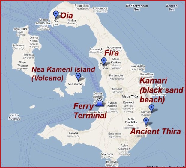
Location of Agra, India.

I visited New Delhi, India on business in March.  It was a good time of year to visit; the weather was quite pleasant–low 80’s F and low humidity. I knew that New Delhi might be as close as I would ever get to the world-renowned Taj Mahal, so I arrived from the U.S. very early Saturday morning to allow myself to recuperate and get to Agra, the city where the Taj Mahal is located, before beginning business on Monday. I was traveling with two business colleagues, and we arranged for a driver to take us to Agra on Sunday. Agra is about 130 miles south of New Delhi.  At the time, it cost about $180 total for the driver (who was our guide also) and the van for the day. It is also possible to fly between the two cities or take a train.

We had originally been discouraged from traveling to Agra that Sunday; due to Holi Festival (celebrating the “triumph of good over bad”) the locals believed our travel might be disrupted by the celebrations.  Actually, it turned out to be a good day to go–the traffic was light, and we found the celebratory crowds to be no problem. We also got to see many people drenched in pastel colors, and we (and our van) got a little splash of color ourselves (learn more on my upcoming “Street Scenes of India” post). Our drive took about 2.5 hours each way, and it was exhilarating to say the least—with cars speeding towards us in our lane, and bicycles, carts, and even elephants on the road and in the towns we passed through.

Taxi to Taj Mahal.

Riding to the Taj Mahal entrance.

We arrived in Agra about 11 am. As we walked to the Taj Mahal entrance, young children were offering all kinds of items for sale.  I bought a little jade elephant and a book. The omnipresent poverty is heartbreaking, and whenever I could buy a little something to help out, I did. The entrance fee to the Taj was about $20, which is incredibly steep in India, but more than worth it.

The term “Taj Mahal” means “Crown Palace” and it doesn’t begin to describe this world wonder. Agra was the capital of the Mughal (Muslim) Empire for over a century. The Shah Jahan, a Mughal emperor for 30 years (1628-1658) built the Palace in memory of his beloved wife of 19 years, Mumtaz Mahal, to immortalize her after her untimely death, at age 39 during the birth of their 14th child (!)  It is said that before her death she requested her husband create a symbol of their love for their posterity. I don’t think she would be disappointed in his attempt to honor her wishes.

The Taj is on the banks of the Yamuna River. The stunning white marble was quarried 230 miles away in Makrana, Rajasthan state.  The 35 different types of precious inlaid stones were imported from all over Asia and the Middle East.

Entrance to Taj Mahal.

Entrance Gate to Taj Mahal.

The entrance gate to the Taj Mahal is quite a sight itself. There are two rows of 11 white pinnacles on the rooftop representing the 22 years it took to construct the mausoleum.

View of Taj Mahal.

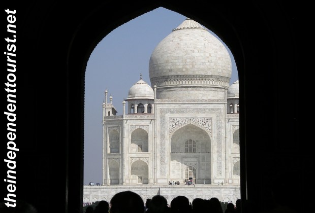
First view of the Taj Mahal.

As the Taj Mahal comes into view, its brilliant white marble is almost blinding in the mid-day sun. It has to be the most beautiful man-made monument in the world. The Taj exudes an awe and reverence today, even 350 years later.

Taj Mahal.

Taj Mahal

Before entering the plinth of the Taj, shoes are removed or covered with slip-on covers, both as a symbol of respect and to keep the plinth and Taj clean. Prior to visiting, I knew very little about the vast inlaid stone work in the marble that is part of the exterior and interior decorations.

Detail of Taj Mahal, India.

Detail of Taj Mahal

Some of the inlaid stone is done in thin multiple layers, and is only visible in certain lighting. Floral patterns come into full bloom when the light shines through the layered stone work.

Detail of marble work at Taj Mahal.

Detail of marble work on Taj Mahal.

I cannot comprehend the effort and expense that went into the Taj’s construction. Even the river flow was altered for the construction. Part of the beauty of the Taj is its total symmetry–the buildings, courtyard and gardens are all balance and symmetrical in their design. The four minarets at each corner of the plinth surrounding the Taj Mahal are constructed in such a way that if they ever fell, they would not damage the main structure.

Inside, in the main level are replicas of the tombs of Shah Jahan and his wife (the actual tombs are located in the crypt below the main level and are not accessible). There are also four rooms inside the mausoleum that were planned for other members of the royal family.

Visitors at Taj Mahal.

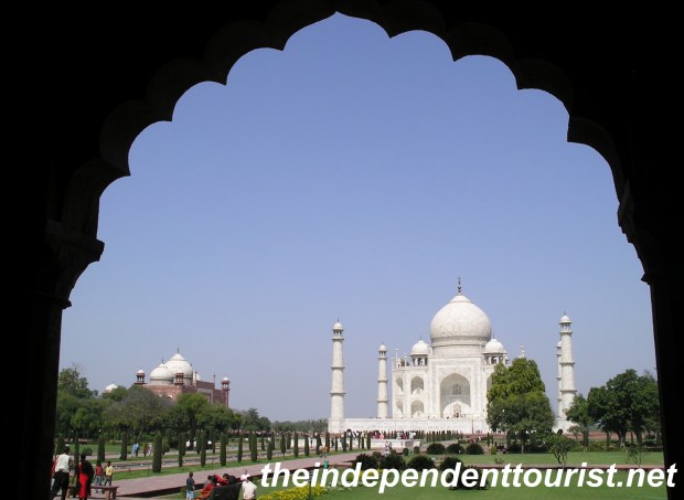
Visitors stroll on the plinth, mosque in background

There are two identical buildings, both mosques, on either side of the Taj. Most pictures do not focus on them, but they are beautiful red sandstone creations in themselves.

Interestingly, Shah Jahan was going to build a replica of the Taj Mahal in all black marble, as his own mausoleum, but did not live long enough to make this dream a reality. He was imprisoned by his son Aurangzeband spent his lastfew years at the Agra Red Fort, not far up the river from the Taj.

View of Taj Mahal, Agra, India.

Our last view of the Taj Mahal

Since we just had the one day, we only had time to visit the Taj Mahal and do a little local rug shopping nearby, before returning to New Delhi. Please note that marble jewelry boxes and other souvenirs representative of the Taj Mahal can be purchased much more cheaply in other locations—ask a local where the best deals are. There a number of other interesting sites in Agra, including the Agra Red Fort (1565), and other exquisite tombs, but none can compare to the Taj Mahal.

I am indebted to Rajaram Panda, Mittal Publications, New Delhi 2007, for the historical and factual information about the Taj Mahal in this post.